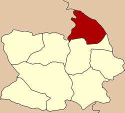
- Manorom District
-
Manorom
มโนรมย์— Amphoe — Amphoe location in Chainat Province Coordinates: 15°18′34″N 100°5′2″E / 15.30944°N 100.08389°ECoordinates: 15°18′34″N 100°5′2″E / 15.30944°N 100.08389°E Country  Thailand
Province Chainat Seat Khung Samphao Area – Total 225.644 km2 (87.1 sq mi) Population (2008) – Total 33,041 – Density 147.9/km2 (383.1/sq mi) Time zone THA (UTC+7) Postal code 17110 Geocode 1802 Manorom (Thai: มโนรมย์) is a district (Amphoe) in the northeastern part of Chainat Province, central Thailand.
Contents
Geography
Neighboring districts are (from the south clockwise) Mueang Chainat, Wat Sing of Chainat Province, Mueang Uthai Thani of Uthai Thani Province, Phayuha Khiri and Takhli of Nakhon Sawan Province.
Administration
The district is subdivided into 7 subdistricts (tambon), which are further subdivided into 41 villages (muban). There are two subdistrict municipalities (thesaban tambon) - Khung Samphao covers parts of tambon Khung Samphao, and Hang Nam Sakhon cover the whole tambon Hang Nam Sakhon and parts of U Taphao. There are further 6 Tambon administrative organizations (TAO).
No. Name Thai Villages Inh.[1] 1. Khung Samphao คุ้งสำเภา 4 6,028 2. Wat Khok วัดโคก 5 3,998 3. Sila Dan ศิลาดาน 7 3,550 4. Tha Chanuan ท่าฉนวน 10 6,827 5. Hang Nam Sakhon หางน้ำสาคร 5 5,551 6. Rai Phatthana ไร่พัฒนา 5 3,711 7. U Taphao อู่ตะเภา 5 3,376 References
- ^ "Population statistics 2008". Department of Provincial Administration. http://www.dopa.go.th/xstat/p5118_01.html.
External links
- amphoe.com (Thai)
Mueang Chainat · Manorom · Wat Sing · Sapphaya · Sankhaburi · Hankha · Nong Mamong · Noen Kham
Categories:- Amphoe of Chainat
- Central Thailand geography stubs
Wikimedia Foundation. 2010.

