- Mangfall
-
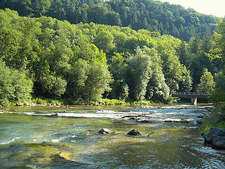
Mangfall Mangfall bend, looking downstream
Data Location Bavaria,  Germany
Reference no. DE: 182 Length 58 km Sources tailstream of the Tegernsee
47°44′52″N 11°44′07″E / 47.74778°N 11.73528°ECoordinates: 47°44′52″N 11°44′07″E / 47.74778°N 11.73528°ESource height 726 m above sea level Mouth in Rosenheim into the Inn
47°51′35″N 12°08′10″E / 47.85972°N 12.13611°EMouth height 444 m above sea level Descent 282 m Basin Danube Progression Inn → Danube → Black Sea Catchment 1,099 km² Right tributaries Schwärzenbach, Schlierach, Moosbach, Leitzach, Hainerbach, Goldbach (auch Mühlbach), Kaltenbrunnbach, Kalten Left tributaries Festenbach (auch Moosbach), Steinbach, Glonn Lakes passed Tegernsee Large towns Rosenheim Small towns Bad Aibling, Kolbermoor The Mangfall is a left tributary of the River Inn in Upper Bavaria and 58 km long. The Mangfall is the tailstream of the Tegernsee lake and discharges near Rosenheim into the Inn.
Towns and villages on the Mangfall
- Bruckmühl
- Götting
- Heufeld
- Bad Aibling
- Kolbermoor
- Rosenheim
Sources
- Wernher Scheingraber, Martin Siepmann (Hrsg.): An Leitzach und Mangfall Bayerland, ISBN 3-89251-178-0
- Klaus J. Schönmetzler, Klaus G. Förg, Kurt Schubert (Hrsg.): Mangfalltal. Edition Förg, Rosenheim 2004, ISBN 3-933708-06-0
- Gerd Hedler, Wilhelm Albrecht, Gerd Lottes (Hrsg.): Leitzach und Mangfall, Christians, Hamburg 1983, ISBN 3-7672-0821-0
External links
- Bayerninfo.de Radwanderweg an der Mangfall
- Durchflussmenge der Mangfall in Rosenheim während der letzten 30 Tage
- Pegel: Rosenheim / Mangfall Bayerisches Landesamt für Umwelt: Niedrigwasser-Informationsdienst

This article was translated from a good article on German Wikipedia 7. Oktober 2006 in this version. Categories:- Mangfall basin
- Rivers of Bavaria
- Miesbach district
- Rosenheim district
Wikimedia Foundation. 2010.

