- Manchester Bridge (Pittsburgh)
-
Manchester Bridge 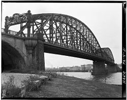
Official name North Side Point Bridge Crosses Allegheny River Locale Pittsburgh, Pennsylvania Design subdivided Pratt through truss Material steel Total length 2,840 feet (870 m) Longest span 2 x 531 feet (162 m) Clearance below 70 feet (21 m) Opened 1915 Closed October 17, 1969 Coordinates 40°26′37″N 80°00′46″W / 40.4435°N 80.0129°WCoordinates: 40°26′37″N 80°00′46″W / 40.4435°N 80.0129°W The Manchester Bridge was a steel Pratt truss bridge that spanned the Allegheny River in Pittsburgh, Pennsylvania.[1]
History
The bridge was constructed from 1911-1915.[2] and was opened by Mayor Joseph G. Armstrong on August 8, 1915.[3] It was closed to traffic on October 17, 1969 when its successor, the Fort Duquesne Bridge (located closer to the Roberto Clemente Bridge) opened that same day. It was demolished in the autumn of 1970. Explosives were used to drop the south side span into the river at 18:42 on September 29, 1970.[4] The original attempt 11 hours earlier was unsuccessful when five of the eight charges failed to detonate. Demolition was subcontracted to Controlled Demolition by Dravos and was overseen by John. D Loizeaux.
See also
References
- ^ "Bridges and Tunnels of Allegheny County - Manchester Bridge 1915-1970". December 7, 2000. http://www.pghbridges.com/pittsburghW/0584-4477/manchester.htm. Retrieved April 28, 2011.
- ^ "Historic American Engineering Record (HAER) No. PA,2-PITBU,59-". April 1970. http://www.loc.gov/pictures/item/PA0064/. Retrieved April 29, 2011.
- ^ "Manchester Bridge Name For New Span". The Pittsburgh Press (Pittsburgh). August 7, 1915. http://news.google.com/newspapers?id=YMUaAAAAIBAJ&sjid=h0kEAAAAIBAJ&dq=manchester%20bridge%20opened&pg=2679%2C1760224. Retrieved May 1, 2011.
- ^ "Manchester Span Blasted Down". Pittsburgh Post-Gazette (Pittsburgh). September 30, 1970. http://news.google.com/newspapers?id=sH5IAAAAIBAJ&sjid=3WwDAAAAIBAJ&dq=manchester%20bridge&pg=3211%2C4590950. Retrieved May 1, 2011.
Bridges of the Allegheny River Upstream
Fort Duquesne Bridge


Manchester Bridge Downstream
West End Bridge
(Ohio River)
Tunnels and bridges in Pittsburgh Tunnels Allegheny River Tunnel · Armstrong Tunnel · Fort Pitt Tunnel · Liberty Tunnel · Mount Washington Transit Tunnel · Pittsburgh and Castle Shannon Tunnel · Pittsburgh & Steubenville Extension Railroad Tunnel · Schenley Tunnel · Squirrel Hill Tunnel · Wabash Tunnel

Bridges 16th Street Bridge · 30th Street Bridge · 31st Street Bridge · 33rd Street Railroad Bridge · 40th Street Bridge · Bloomfield Bridge · Birmingham Bridge · Fort Duquesne Bridge · Fort Pitt Bridge · Fort Wayne Railroad Bridge · George Westinghouse Bridge · Glenwood Bridge · Glenwood B&O Railroad Bridge · Highland Park Bridge · Homestead Grays Bridge · Hot Metal Bridge · Liberty Bridge · McKees Rocks Bridge · Panhandle Bridge · Panther Hollow Bridge · Schenley Bridge · Senator Robert D. Fleming Bridge · Smithfield Street Bridge · South Tenth Street Bridge · Three Sisters (Roberto Clemente Bridge, Andy Warhol Bridge, Rachel Carson Bridge) · Veterans Bridge · West End Bridge
Categories:- Bridges in Pittsburgh, Pennsylvania
- Bridges over the Allegheny River
- Demolished bridges in the United States
- Road bridges in Pennsylvania
- United States bridge (structure) stubs
- Pennsylvania building and structure stubs

Wikimedia Foundation. 2010.