- Scugog
-
Scugog — Township — Port Perry and Lake Scugog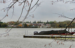 Location of Scugog in Durham Region
Country  Canada
Province  Ontario
Regional Municipality Durham Region Established 1974 Government – Mayor Chuck Mercier – Council Bobbie Drew (Regional Councillor), Larry Corrigan (Ward 1), John Hancock (Ward 2), Jim Howard (Ward 3), Wotten, Wilma (Ward 4), Howard Danson (Ward 5) – MP Beverley Joan "Bev" Oda – Member of Provincial Parliament John O'Toole Area[1] – Land 474.63 km2 (183.3 sq mi) Population (2006)[1] – Total 21,439 – Density 45.2/km2 (117.1/sq mi) Time zone EST (UTC-5) – Summer (DST) EDT (UTC-4) Postal Code FSA Area code(s) 289 / 905 Website www.township.scugog.on.ca Scugog is a township in the Regional Municipality of Durham, south-central Ontario, Canada. A smaller Scugog Township was also a historic municipality and geographic township prior to the amalgamation that formed the current municipality.
Contents
History
The original township of Scugog was originally divided between Reach and Cartwright townships in Ontario County and Northumberland and Durham County, respectively. When Lake Scugog was created by a dam in Lindsay in 1834, flooding created an island known as Scugog Island. The island was separated from Reach and Cartwright to form Scugog Township in 1856. The new township was part of Ontario County.
According to Alan Rayburn's Place Names of Ontario, the name Scugog is derived from the Mississauga word sigaog, which means "waves leap over a canoe." This refers to the creation of Lake Scugog. Other sources indicate that it is a native word meaning swampy or marshy land.
The creation of the Regional Municipality of Durham in 1974 resulted in municipal restructuring of the various townships in Ontario County. The current township of Scugog was created through the amalgamation of the original townships of Scugog, Reach and Cartwright and the town of Port Perry.
Current municipality
Port Perry is the chief commercial and administrative centre of the municipality. The township also includes the communities of Aldreds Beach, Blackstock, Burketon, Cadmus, Caesarea, Carnegie Beach, Cedar Shores, Epsom, Fralicks Beach, Gerrows Beach, Greenbank, Highland Beach, Honey Beach, Lakeside Beach, Manchester, Marsh Hill, Nestleton, Nestleton Station, Pine Point, Port View Beach, Prince Albert, Prospect, Purple Hill, Saintfield, Scugog, Scugog Centre, Scugog Point, Seagrave, Shirley, Strattonville, Sunrise Beach, Utica, Victoria Corners and Williams Point.
The largest private-sector employer in the area is the Great Blue Heron Casino, located on the Scugog First Nation on Scugog Island. Schneider Meats also has a facility in the Township. The Township is also a popular tourist destination due to the casino and recreational opportunities from Lake Scugog. Many residents also commute to other Durham Region communities and further afield.
Demographics
According to the 2006 Statistics Canada Census:[1]
- Population:
- 2006: 21,439
- 2001: 20,173
- % Change (2001-2006): 6.3
- Dwellings: 8,345
- Area (km²): 474.63
- Density (persons per km²): 45.2
In film
- Parts of the 1996 film Fly Away Home were filmed in Scugog as were parts of Welcome to Mooseport.
References
- ^ a b c Statistics Canada 2006 Census - Scugog community profile
External links
- Township of Scugog
- Downloadable 1:50 000 topographical map of Scugog (map 31D02), by the Ministry of Natural Resources

Brock Uxbridge 
Kawartha Lakes  Scugog

Whitby, Oshawa, Clarington Municipalities of Durham Region, Ontario Greater Toronto Area Largest city: TorontoRegions 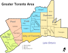
Cities Towns Ajax • Aurora • Caledon • East Gwillimbury • Georgina • Halton Hills • Markham • Milton • Newmarket • Oakville • Richmond Hill • WhitbyTownships and municipalities Categories:- Township municipalities in Ontario
- Municipalities in Durham Region
- Population:

Wikimedia Foundation. 2010.