- Portugués Urbano
-
Barrio Portugués Urbano Location of barrio Portugues Urbano within the municipality of Ponce shown in red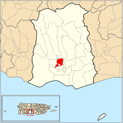
Country  United States
Territory  Puerto Rico
Municipality  Ponce
PonceArea – Total 1.14 sq mi (3 km2) – Land 1.14 sq mi (3 km2) – Water 0.00 sq mi (0 km2) Population (2000) – Total 5,886 – Density 5,163/sq mi (1,993.4/km2) Source: 2000 Census Portugués Urbano is one of the 31 barrios in the municipality of Ponce, Puerto Rico. Along with Canas Urbano, Machuelo Abajo, Magueyes Urbano, and San Antón, Portugués Urbano is one of the municipality's five originally rural barrios that are now also part of the urban zone of the city of Ponce.
Contents
Location
Portugués Urbano is an urban barrio located in the southern section of the municipality, north of the core of the city of Ponce at Plaza Las Delicias, and within the city limits of the city of Ponce.
Boundaries
It is bounded on the North by Camino de Ponce (Golf Club) Street, Majagua Street, and Arboleda Street, on the South by Idilid Street, Shangai Street, Diez Street, Cinco Street, Pico Dulce Street, and Paseo de la Cruceta, on the West by Novedades Street, the hills east of Ponce Cement and the future western branch of PR-9, and on the East by Río Portugues (roughly), PR-503 (roughly), Cayey Street, Cerro San Tomas Street.[1][2]
In terms of barrio-to-barrio boundaries, Portugués Urbano is bounded in the North by Portugués, in the South by Canas Urbano and Segundo, in the West by Magueyes Urbano, and in the East by Machuelo Arriba and Sexto.[3] [4]
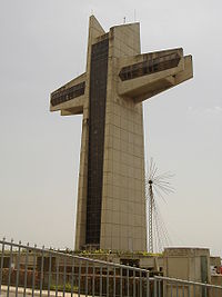 The El Vigia Cross is a well-known landmark located in Barrio Portugues Urbano
Features and demographics
The communities of Mameyes, El Vigia, and Jaime L. Drew, are located within the limits of barrio Portugués Urbano.
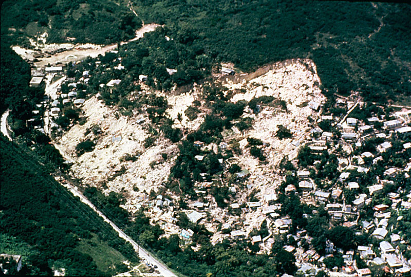
Portugués Urbano has 1.14 square miles (3.0 km2) of land area and no water surface area. In 2000, the population of Portugués Urbano was 5,886 persons, and it had a density of 5,163 persons per square mile. [5][6] The Mameyes landslide tragedy occurred here.
The highest point in Barrio Portugués Urbano is Cerro Ponce 2 which stands at 574 feet. Another notable land feature is Cerro El Vigia which stands at 364 feet.[7]
Mameyes landslide
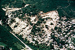 The 1985 Mameyes landslide in Barrio Portugués Urbano killed over 100 people. It is the worst landslide disaster in North America
Portugués Urbano attracted attention recently when, in 1985, over 100 people were buried in their sleep from a landslide as a result of heavy rains, in the Mameyes sector of Barrio Portugués Urbano.[8][9]On October 7, 1985, Ponce was the scene of this major tragedy, when at least 129 people lost their lives to a mudslide in the Mameyes sector of Barrio Portugués Urbano.[10] [11] The heavy rains were part of the Tropical Storm Isabel system. International help was needed to rescue people and corpses. The United States and many other countries, including Mexico, France, and Venezuela, sent economic, human, and machinery relief. The municipal government, subsequently, moved the remaining residents of the sector to newly-built homes in a safer area of the municipality.
Notable landmarks
Barrio Portugués Urbano is home to Serralles Castle and Cruceta El Vigía, both tourist attractions.[12]
Coordinates: 18°01′37″N 66°37′20″W / 18.0268832°N 66.6222360°W[13]
References
- ^ General Purpose Population Data, Census 2000. Unidad de Sistemas de Información Geográfica, Área de Tecnología de Información Gubernamental, Oficina de Gerencia y Presupuesto. Gobierno de Puerto Rico. Retrieved February 20, 2010.
- ^ Ponce Topographic Map. Map Styles: Map and Shaded. Trails.com. From: United States Geological Survey. Topo Map. Projection: NAD83/WGS84. Retrieved February 22, 2010.
- ^ General Purpose Population Data, Census 2000. Unidad de Sistemas de Información Geográfica, Área de Tecnología de Información Gubernamental, Oficina de Gerencia y Presupuesto. Gobierno de Puerto Rico. Retrieved February 22, 2010.
- ^ Areciboweb. Ponce. Barrios. Retrieved February 22, 2010.
- ^ US Census. Population, Land area, and density of Barrio Portugues Urbano Retrieved February 2, 2010.
- ^ Boricua Online. Population of Barrio Canas Urbano.
- ^ Maptest. Government of the Commonwealth of Puerto Rico. General Purpose Population Data, Census 2000. Unidad de Sistemas de Información Geográfica, Área de Tecnología de Información Gubernamental, Oficina de Gerencia y Presupuesto. Gobierno de Puerto Rico. Retrieved 10 November 2011.
- ^ 7 de octubre de 1985: Un drama, múltiples huellas y lecciones.Reinaldo Millán. La Perla del Sur. Ponce, Puerto Rico. 7 October 2009. Retrieved 27 October 2011.
- ^ Map Showing Susceptibility to Rainfall-triggered Landslides in the Municipality of Ponce, Puerto Rico: Scientific Investigations Map I-2818. By Mattew C. Larsen, Marylin Santiago, Randall Jibson, and Eduardo Questell. USGS. 2004. Contrary to popular belief, Mameyes in not located in barrio Tibes. Mameyes is located in Barrio Portugues Urbano (Please see map). Retrieved March 1, 2010.
- ^ Landslides in Puerto Rico
- ^ Map Showing Susceptibility to Rainfall-trigerred Landslides in the Municipality of Ponce, Puerto Rico: Scientific Investigations Map I-2818. By Mattew C. Larsen, Marylin Santiago, Randall Jibson, and Eduardo Questell. USGS. 2004. Site of the Mameyes Landslide. Geopolitical Map of the Municipality. Retrieved February 25, 2010.
- ^ General Purpose Population Data, Census 2000. Unidad de Sistemas de Información Geográfica, Área de Tecnología de Información Gubernamental, Oficina de Gerencia y Presupuesto. Gobierno de Puerto Rico. Retrieved February 22, 2010.
- ^ U.S. Geological Survey Geographic Names Information System: Portugués Urbano Barrio
See also
Categories:- Barrios of Ponce


Wikimedia Foundation. 2010.