- Maisemore
-
Coordinates: 51°53′20″N 2°16′16″W / 51.889°N 2.271°W
Maisemore 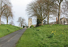
St Giles Parish church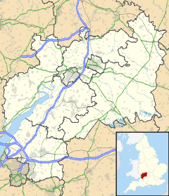
 Maisemore
Maisemore shown within GloucestershirePopulation 488 OS grid reference SO814212 District Tewkesbury Shire county Gloucestershire Region South West Country England Sovereign state United Kingdom Post town GLOUCESTER Postcode district GL2 Dialling code 01452 Police Gloucestershire Fire Gloucestershire Ambulance Great Western EU Parliament South West England UK Parliament Forest of Dean List of places: UK • England • Gloucestershire Maisemore is a village and civil parish in Gloucestershire, England. It lies on the A417 road 2.5 miles northwest of Gloucester, on the west bank of the River Severn. In the 2001 census the parish had a population of 488.[1] There is a church, dedicated to St Giles.[2]
Maisemore Bridge connects the village to Alney Island, and provides a viewpoint for the Severn bore. Maisemore Weir and Lock were built in about 1870.[3] The weir is at the upper limit of the tides on the Severn. The lock is no longer in use.
The name of the village appears to be of Welsh origin, meaning "great field" (Welsh: maes mawr).[4] The northern part of Alney Island, which is within the parish of Maisemore, is known as Maisemore Ham, combining Welsh and Old English words for field or meadow (ham, meaning "meadow"[5]).
The area is prone to flooding, which from time to time closes the A417 between Maisemore and Gloucester, especially in the spring when the swollen River Severn meets high tides coming up the estuary.
Notable residents
- George Wilson Bridges was rector here in 1843 (where he found his interest in photography)[6]
- William Stephen Raikes Hodson was born on 9 March 1821 at Maisemore Court, the third son of the curate, Rev. George Hodson.
References
- ^ ONS Census 2001
- ^ Maisemore, St Giles - a church near you
- ^ Victoria County History of Gloucestershire: Gloucester Quays and Docks
- ^ Mills, A.D. and Room, A, A Dictionary of British Place-Names Oxford University Press
- ^ Oxford English Dictionary
- ^ Encyclopedia of nineteenth-century photography, Volume 1, John Hannavy, accessed September 2009]
External links
 Media related to Maisemore at Wikimedia CommonsCategories:
- Villages in Gloucestershire
- Gloucestershire geography stubs


Wikimedia Foundation. 2010.