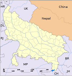
Maharajpur, Kanpur

Maharajpur, Kanpur
Maharajpur
—  town  —
Maharajpur
Location of Maharajpur
in Uttar Pradesh and India
Coordinates 26°20′0″N 80°29′0″E / 26.333333°N 80.483333°E / 26.333333; 80.483333Coordinates: 26°20′0″N 80°29′0″E / 26.333333°N 80.483333°E / 26.333333; 80.483333
Country India
State Uttar Pradesh
District(s) Kanpur
Time zone IST (UTC+05:30)
Area

• Coastline


0 kilometres (0 mi)

Maharajpur is a town in Kanpur district in the state of Uttar Pradesh, India located at an elevation of 121 m above MSL. Maharajpur is well connected by rail and road.


Wikimedia Foundation. 2010.

Игры ⚽ Нужна курсовая?

Look at other dictionaries:

  • National Highway 2 (India) — NH 2 redirects here. NH 2 may also refer to New Hampshire s 2nd congressional district …   Wikipedia

  • Maintenance Command, Indian Air Force — Emblem of the Maintenance Command Founded 26 January 1955 Country India …   Wikipedia

  • List of RAF stations — This List of RAF stations is a comprehensive list of all stations, airbases, airfields and administrative headquarters of the Royal Air Force past and present.:Note Current RAF Stations will be listed under the currently recognised county of the… …   Wikipedia

  • Tikamgarh — This article is about the municipality in Madhya Pradesh, India. For its namesake district, see Tikamgarh District. Tikamgarh टीकमगढ़ The Land of Glorious Past   city and district headquarters   …   Wikipedia

  • Tikamgarh District — This article is about the district. For its eponymous headquarters, see Tikamgarh. Tikamgarh district टीकमगढ़ जिला …   Wikipedia

  • List of cities and towns in India — This is a list of cities in India whose population is above 20,000. According to Census 2001 data cities and towns are broadly classified as: Class I – Population greater than 100,000 Class II – Population between 80,000 – 99,999 Class III –… …   Wikipedia

Share the article and excerpts

Direct link
Do a right-click on the link above
and select “Copy Link”