- Expressway S3 (Poland)
-
Expressway S3
Route information Part of  E65
E65Length: 117.6 km (73.1 mi)
470 km (292 mi) plannedMajor junctions From: Świnoujście  merge with A6 east of Szczecin
separation from A6 south of Szczecin
 A2 near Świebodzin (planned)
 A4 near Legnica (planned)
To:  R11, border with Czech Republic
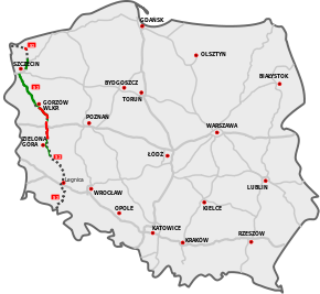
Location Major cities: Szczecin, Gorzów Wielkopolski, Zielona Góra Highway system Expressway S3 or express road S3 (in Polish droga ekspresowa S3) is major road in Poland which is planned to run from Świnoujście on the Baltic Sea through Szczecin, Gorzów Wielkopolski, Zielona Góra and Legnica, to the border with the Czech Republic, where it will connect to the D11 motorway. The total planned length is 470 km (290 mi), of which 117.6 km (73.1 mi) is open to traffic (about half with single carriageway only) and 63.6 km (39.5 mi) is under construction (as of October 2010). According to current plans the whole road should be finished by 2015.[citation needed]
Motorway A3 was planned to be built along this route before, but the decision was made to build a lower standard "express road" as the traffic density was judged too low to justify an autostrada. One legacy of this planning is that for some of its route S3 is going to be built on a completely new alignment some distance away from the parallel DK3 road it is to replace. This is in contrast to most "express roads" in Poland which are built by upgrading existing roads.
The most recent large extension of S3 is the 81.6 km section section south of Szczecin to Gorzów Wlkp. This section has been built on a new alignment, outside of towns, and is essentially of motorway standard.[1]
References
See also
National roads, motorways and expressways in Poland National roads 1 · 2 · 3 · 4 · 5 · 6 · 7 · 8 · 9 · 10 · 11 · 12 · 13 · 14 · 15 · 16 · 17 · 18 · 19 · 20 · 21 · 22 · 23 · 24 · 25 · 26 · 27 · 28 · 29 · 30 · 31 · 32 · 33 · 34 · 35 · 36 · 37 · 38 · 39 · 40 · 41 · 42 · 43 · 44 · 45 · 46 · 47 · 48 · 49 · 50 · 51 · 52 · 53 · 54 · 55 · 56 · 57 · 58 · 59 · 60 · 61 · 62 · 63 · 64 · 65 · 66 · 67 · 68 · 69 · 70 · 71 · 72 · 73 · 74 · 75 · 76 · 77 · 78 · 79 · 80 · 81 · 82 · 83 · 84 · 85 · 86 · 87 · 88 · 90 · 91 · 92 · 93 · 94 · 98Motorways 
Expressways  S1 · S2 · S3 · S5 · S6 · S7 · S8 · S10 · S11 · S12 · S14 · S17 · S19 · S22 · S51 · S61 · S69 · S74 · S79 · S86Categories:
- Expressways in Poland
- Proposed roads in Poland
- Poland road stubs


Wikimedia Foundation. 2010.