- Dniester Canyon
-
Dniester Canyon (Дністровський каньйон) National Park 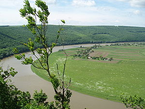 Dniester landscape in West Ukraine
Country Ukraine Region Ternopil Oblast Districts Borshchiv Raion, Buchach Raion, Zalischiky Raion, Monastyryska Raion Range Podolian Upland Tributaries - left Zolota Lypa, Koropets, Stripa, Dzhuryn, Seret, Zbruch Landmarks Dzhuryn Waterfall, Rusyliv Waterfall Cascade River Dniester Length 250 km (155 mi), East–West Area 108.29 km2 (42 sq mi) - State owned 71.897 km2 (28 sq mi) - Communal 36.395 km2 (14 sq mi) Geology Karst, Limestone, Travertine Period Silurian Animal Sterlet, European Otter, European Badger, Wildcat, Lynx, Coluber National Park 2010 - Landscape Park 1990 Management Ministry of Environment - location Kiev IUCN category II - National Park Recognition Seven Natural Wonders of Ukraine  Dniester Canyon, close to the mouth of Strypa, Ternopil region.

Dniester Canyon — the Dniester River canyon, located at the territory of Dniester River Valley in Ukraine. On February 3, 2010, the Regional landscape park "Dnister Canyon" was promoted to the status of the National Nature Park.[1]
Contents
Overview
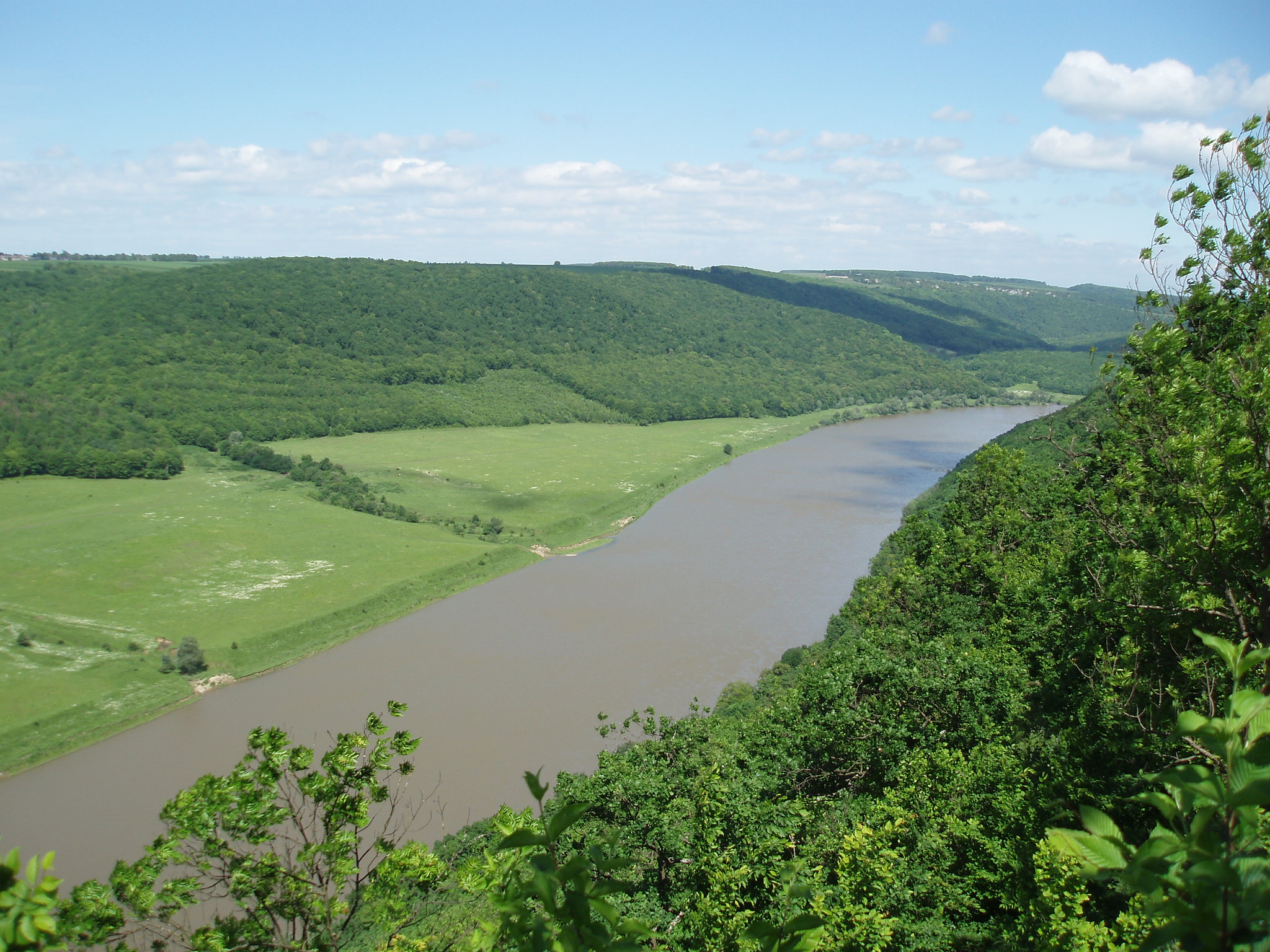
Main article: Dniester RiverThe Dniester River is the second largest and the most ecologically clean river in Ukraine. Canyon is partly flooded by reservoir waters. Its depth reaches near fifty meters at its maximum. Dniester Canyon is 250 km (155 mi) river segment from the mouth of Zolota Lypa River to the mouth of Zbruch. Here Dniester flows in a canyon valley with depth 80–200 m (260–650 ft). The canyon nature is original and unique. Geological, botanical, archaeological, hydrological sights form unique landscapes here. In separate places there are areas with valuable arboreal or shrub breeds, age-old and exotic things trees.
Dniester Canyon is the most interesting and the most picturesque area of the Dniester River. The steep canyon slopes are of limestone and the nature of the area is particularly beautiful, as it was chosen as one of 7 natural wonders of Ukraine.
The Dniester slopes are covered with a lot of rare plants and are a house for hundreds of types of animals and birds.
The Dniester canyon is an original open-air-museum, where the best creations of living and lifeless nature are collected in virgin and harmonious combination. Within the canyon there are more than ten karst caves and grottoes. The whimsical view of such caves from the river reach level especially impresses, and small waterfalls of so called «girlish tears», which run along copse thick bryophyte rocks, present spectacle of a unique beauty.
Landscape
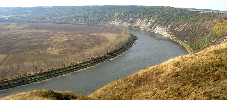
The most valuable and picturesque part of the whole Dniester is the 250 km-stretch from the mouth of the river Zolota Lypa to the mouth of the river Zbruch, which is called the Dnister Canyon. The nature of the Dniester Canyon is specific and original. These are first of all picturesque landscapes and their versatility which impart contribute to the originality of these routes. The steep rocky or wooden banks with the heights to 200 m (650 ft), unique travertine rocks and geological exfoliation, caves and grottoes with signs of human settlement upon them, waterfalls, picturesque islands, monuments of nature, history, architecture, ethnography – all these can be seen miles and miles. And all this is a wild and virginal nature which gives a perfect possibility to plunge into the world of silence and calmness.
Canyon segments
Dniester Canyon is a 250 km (155 mi) segment of Dniester River from the mouth of Golden Tilia (Zolota Lypa) to the mouth of Zbruch.
- Dniestrovo-Beremyanskiy Canyon (situated between villages Hubyn – Beremiany – Khmeleva) is another canyon within. Its depth reaches 200 m (650 ft), width – from 1 to 5 km (0.5-3 mi), length – 10 km (6 mi).
Protection
The Dniester Canyon National Park is planned to be established along the Dniester River course.
Tourism
The Dniester Canyon attracts thousands of water tourists each year.
Alloy on the Dniester river is one of the most interesting trips in Ukraine. Picturesque landscapes include steep rocky or forest banks of 200 m high, unique travertine rocks and geological removed layers, caves and grottoes, waterfalls, islands, monuments of nature, history, architecture, ethnography.
Skydiving
The villages of Isakiv and Odaiv that are located at the canyon attract skydivers not only from Ukraine, but also from Belarus, Russia, Poland, Germany, and many other countries. Twice a year All-Ukrainian and International skydiving competition takes place here.
References
External links
- Seven Natural Wonders of Ukraine: Dniester Canyon
- The Dnister Canyon (with photos)
- Дністровський каньйон
- Presidential Decree on creation of Dniester Canyon National Park
Askania-Nova · Granite-steppe lands of Buh · Dniester Canyon · Marble Caves · Podillian Tovtry · Lake Svitiaz · Lake Synevir

Biosphere reserves National nature reserves Gorgany · Dnieper-Oril · Drelinia · Yelanetsky Steppe · Kazantip · Kaniv · Karadah · Crimea · Kuziy · Luhansk · Marmarosh · Medobory · Mys Martian · Mykhailiv Tsilyna · Opuk · Polissya · Roztochya · Rivne · Ukrainian Steppe · Cheremske · Yalta Mountain ForestNational nature parks Azov-Syvash · Biloberezhia of Sviatoslav · Bilo-ozersky · Buzk's Gard · Velyky Luh · Verkhovyna · Vyzhnytsia · Halych · Hetman · Holosiiv · Homolsh Woods · Hutsulshchyna · Dvorichna · Derman-Ostroh · Desna-Starahuta · Dzharylhak · Zalissya · Ichnya · Karmelyuk's Podillya · Carpathian · Kremenets Mountains · Mezynsky · Lower Dniester · Lower Sula · Pyryatyn · Northern Podillya · Podilian Tovtry · Azov · Prypiat-Stokhid · Holy Mountains · Synevir · Synyohora · Siversky Donetsk · Skole Beskids · Sloboda · Tuzla Lagoons · Uzhanian · Khotyn · Charming Harbor · Cheremosh · Shatsk · YavorivCategories of protected areas of Ukraine Categories:- Ternopil Oblast geography stubs
- Canyons and gorges of Ukraine
- Ternopil Oblast
- Parks in Ukraine
- Protected areas of Ukraine

Wikimedia Foundation. 2010.