Dismal River (Nebraska)

Dismal River (Nebraska)
Small river running between steep banks
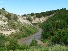
Looking downstream (east) from Nebraska Highway 97 crossing

The Dismal River is a winding 71.9-mile-long (115.7 km)[1] river in the state of Nebraska. It is formed by the confluence of two forks, one of which has its origins in Grant County and the other in Hooker County. The forks meet near Nebraska Highway 97 between Mullen and Tryon. From here the Dismal River flows east-southeast into Thomas County, crossing U.S. Highway 83 south of Thedford. Passing just south of the Nebraska National Forest (once the Dismal River National Forest), it turns slightly to the northeast before its confluence with the Middle Loup River just west of Dunning in Blaine County.

Most of the land along the river is privately owned and used for ranching. The water comes from the Ogalalla Aquifer and boils up beneath the river in places, sometimes creating areas of quicksand.[2] Deer, coyotes, beavers, turkey and rattlesnakes inhabit the area along the river.

Though much of the river's length is unpopulated, the Dismal River Golf Course, designed by Jack Nicklaus, borders it south of Mullen.

References

  1. ^ U.S. Geological Survey. National Hydrography Dataset high-resolution flowline data. The National Map, accessed March 30, 2011
  2. ^ Guhman, Anne Irene, and Darryll T. Pederson (1992). "Boiling sand springs, Dismal River, Nebraska: Agents for formation of vertical cylindrical structures and geomorphic change". Geology. v.20, no. 1, pp. 8-10. Retrieved 2010-08-03.

External links


Wikimedia Foundation. 2010.

Игры ⚽ Поможем написать реферат

Look at other dictionaries:

  • Dismal River National Forest — was established as the Dismal River Forest Reserve by the General Land Office in Nebraska on April 16, 1902 with 85,123 acres (344.48 km2). After the transfer of federal forests to the U.S. Forest Service in 1905, it became a National Forest …   Wikipedia

  • Nebraska National Forest — IUCN Category VI (Managed Resource Protected Area) …   Wikipedia

  • Dismal Swamp Canal — U.S. National Register of Historic Places U.S. Historic district …   Wikipedia

  • Liste der Flüsse in Nebraska — Die Liste der Flüsse in Nebraska nennt alle Flüsse im US Bundesstaat Nebraska in alphabetischer Reihenfolge und nach Einzugsgebieten geordnet. Inhaltsverzeichnis 1 Alphabetische Reihenfolge 2 Nach Einzugsgebieten 2.1 Einzugsgebiet des Missouri… …   Deutsch Wikipedia

  • List of rivers of Nebraska — This is a partial list of rivers in Nebraska (U.S. state).Alphabetically*Arikaree River *Big Blue River *Big Nemaha River *Calamus River *Cedar River *Dismal River *Elkhorn River *Frenchman Creek *Keya Paha River *Little Blue River *Little Nemaha …   Wikipedia

  • Sand Hills (Nebraska) — Sand Hills Region Sand Hills in Hooker County, near sunset in October …   Wikipedia

  • Lipan — Wohngebiete der Lipan Lipankrieger Die Lipan (Eigennam …   Deutsch Wikipedia

  • John Howell (American football) — This article is about the U.S. football player. For the U.S. Navy admiral, see John Adams Howell.John Howell (born April 28, 1978, in North Platte, Nebraska) is a National Football League safety. He is currently a free agent. He played for the… …   Wikipedia

  • Apache — Infobox Ethnic group group = Apache poptime = 31,000+Fact|date=October 2007 popplace = Arizona, New Mexico and Oklahoma rels = Shamanism, Christianity langs = Chiricahua, Jicarilla, Lipan, Plains Apache, Mescalero, Western Apache related =… …   Wikipedia

  • Tonkawa — Die Titska Watitch oder Tickanwatic (‘Echte, Wirkliche Menschen’), besser bekannt als Tonkawa (sprich: ‘TOHNK ayh wah’, abgel. aus dem Waco tonk a weya ‘Jene, die zusammenbleiben’), waren ein Indianer Stamm der ursprünglich im heutigen östlichen… …   Deutsch Wikipedia

Share the article and excerpts

Direct link
Do a right-click on the link above
and select “Copy Link”