- Dioïla Cercle
-
Dioïla — Cercle — Location of Dioïla Cercle in Mali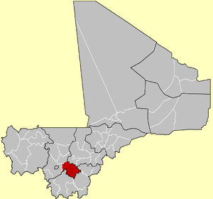
Country  Mali
MaliRegion Koulikoro Region Capital Dioïla Area[1] – Total 12,794 km2 (4,939.8 sq mi) Population (2009 census)[2] – Total 249,403 – Density 19.5/km2 (50.5/sq mi) Time zone GMT (UTC+0) Dioïla Cercle is an administrative subdivision of the Koulikoro Region of Mali. Its seat is the town of Dioïla. It lies at the southeast corner of the region, and prior to 1977, it was combined with what is now Kati Cercle and the District of Bamako in the "Bamako Cercle", with the capital city as its seat.
The Dioïla Cercle is divided into 23 communes:[3][4]
- Kéréla
- Kilidougou
- Massigui
- N'Dlondougou
- N'Garadougou
- N'Golobougou
- Nangola
- Niantjila
- Ténindougou
- Wacoro
- Zan Coulibaly
Dioïla Cercle is home to primarily Bambara farmers, and formed part of the pre-colonial Bambara Empire. Because of this, and its rural character, Animism persisted in this area well into the 20th century. There are also populations of Muslim Maraka, Fula, and Bozo fishing communities. The Cercle falls largely south of the dryer Sahel land, in the wetter Sudan. It is also home to the headwaters of the Bani River.
References
- ^ (in French) Synthèsis des Plans de Securité Alimentaire des Communes du Cercle Dioïla 2008-2012, Commissariat à la Sécurité Alimentaire, République du Mali, USAID-Mali, 2008, http://www.aec.msu.edu/fs2/mali_fd_strtgy/plans/koulikoro/dioila/PSA_synt_cercle_dioila.pdf.
- ^ (in French) Resultats Provisoires RGPH 2009 (Région de Koulikoro), République de Mali: Institut National de la Statistique, http://instat.gov.ml/documentation/koulikoro.pdf.
- ^ (in French) Loi N°99-035/ du 10 Aout 1999 Portant Création des Collectivités Territoriales de Cercles et de Régions, Ministère de l'Administration Territoriales et des Collectivités Locales, République du Mali, 1999, http://www.matcl.gov.ml/PDF/LoiCreationCercleReg.pdf.
- ^ (in French) Communes de la Région de Koulikoro, Ministère de l’administration territoriale et des collectivités locales, République du Mali, http://www.matcl.gov.ml/pdf/ComRegKoulikoro.pdf. Names of communes are in upper-case without accents.
 Cercles of Mali
Kayes Region 
Koulikoro Region Sikasso Region Bongouni · Kolondieba · Kadiolo · Koutiala · Sikasso · Yanfolila · YorossoSégou Region Mopti Region Tombouctou Region Gao Region Kidal Region Abeïbara · Kidal · Tin-Essako · TessalitBamako Capital District Communes and towns of the Koulikoro RegionCapital:KoulikoroBanamba Cercle Banamba (Banamba) · Ben Kadi (Samakele) · Boron (Boron) · Duguwolowula (Touba) · Kiban (Kiban) · Madina Sacko (Madina Sacko) · Sebete (Sebete) · Toubakoro (Toubakoro)
Dioila Cercle Banko (Banko) · Benkadi (Kotoula) · Binko (Tingole) · Degnekoro (Degnekoro) · Diebé (Diebé) · Diédougou (Belekosoba) · Diouman (Dioumanzana) · Dolendougou (Dandougou) · Guegneka (Fana) · Jekafo (Jekafo) · Kaladougou (Diolila) · Kemekafo (Senou) · Kerela (Kerela) · Kilidougou (N'Tobougou) · Massigui (Massigui) · Nangola (Nangola) · Niantjila (Niantjila) · N'Dolondougou (Mena) · N'Garadougou (N'Gara) · N'Golobougou (N'Golobougou) · Tenindougou (Falako) · Wacoro (Wacoro) · Zan Coulibaly (Marka Coungo)Kangaba Cercle Kangaba (Minidian Kangaba) · Balan Bakama (Namakama) · Benkadi Habaladougou (Kéniéba) · Kaniogo (Kaniogo) · Karan (Karan) · Maramandougou (Figuira-Toma) · Narena (Narena) · Nouga (Keliegoue) · Selefougou (Selefougou)Koulikoro Cercle Kolokani Cercle Kolokani (Kolokani) · Didieni (Didieni) · Guihoyo (Guihoyo) · Massantola (Massantola) · Nossombougou (Nossombougou) · Nonkon (Nonkon) · Ouolodo (Ouolodo) · Sagabala (Sagabala) · Sebecoro (Sebecoro) · Tioribougou (Tioribougou) ·Kati Cercle Kati (Kati) · Baguineda-Camp (Baguineda-Camp) · Bankoumana (Bankoumana) · Bossofala (Neguela) · Bougoula (Bougoula) · Daban (Daban) · Diago (Diago) · Dialakoroba (Dialakoroba) · Dialakorodji (Dialakorodji) · Diédougou (Torado) · Dio-Gare (Dio-Gare) · Dogodouman (Dogodouman) · Dombila (Dombila) · Doubabougou (Doubabougou) · Faraba (Faraba) · Kalabancoro (Kalabancoro) · Kalifabougou (Kalifabougou) · Kambila (Kambila) · Kourouba (Kourouba) · Mandé (Ouezzindougou) · Moribabougou (Moribabougou) · Mountougoula(Mountougoula) · N'Gabacoro (N'Gabacoro-Droit) · N'Gouraba (N'Gouraba) · Niagadina (Niagadina) · Nioumamakana (Nioumamakana) · N'Tjiba (Faladie) · Ouelessebougou (Ouelessebougou) · Safo (Safo) · Sanankoro Djitoumou (Sanankoro Djitoumou) · Sanankoroba (Sanankoroba) · Sangarebougou (Sarambougou) · Siby (Siby) · Tiakadougou-Dialakoro (Tiakadougou-Dialakoro) · Tiele (Tiele) · Yelekebougou (Yelekebougou)Nara Cercle Coordinates: 12°29′24″N 6°47′20″W / 12.490°N 6.789°W
Categories:- Cercles of Mali
- Koulikoro Region
- Koulikoro Region geography stubs


Wikimedia Foundation. 2010.