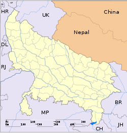
- Derapur
-
Derapur — town — Coordinates 26°25′0″N 79°48′0″E / 26.416667°N 79.8°ECoordinates: 26°25′0″N 79°48′0″E / 26.416667°N 79.8°E Country India State Uttar Pradesh District(s) Kanpur Dehat Time zone IST (UTC+05:30) Area
• Elevation
• Coastline
• 124 metres (407 ft)
• 0 kilometres (0 mi)Codes-
• Vehicle • UP-
Derapur is a town in Kanpur Dehat district in the state of Uttar Pradesh, India. It is the headquarters of the Tehsil of the same name. Derapur is 61 km from Kanpur.
Contents
Demographics
As of 2001 India census Derapur had a population of 5515 Males constitute 52.49% of the population and females 47.51%.
Transport
It is well connected by rail and road.By Rail From Rura Station 16KM, And by N.H-2 only 6 KM . Its Setuated on bank of river Sengur .Having Police Station , Tahsil' Post office, 2 National and 3 other Bnaks, 1 Inter and 1 Digree college .
Geography
Derapur is located at 26°25′0″N 79°48′0″E / 26.416667°N 79.8°E. It has an average elevation of 124 meters (410 feet)
External links
Categories:- Cities and towns in Kanpur Dehat district
- Kanpur division geography stubs
-
Wikimedia Foundation. 2010.


