Denson Seamount

Denson Seamount
Denson Seamount
Map of the Kodiak-Bowie seamount chain
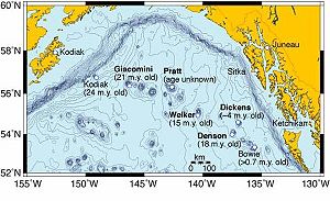
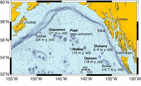
Map of the Kodiak-Bowie Seamount chain
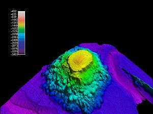
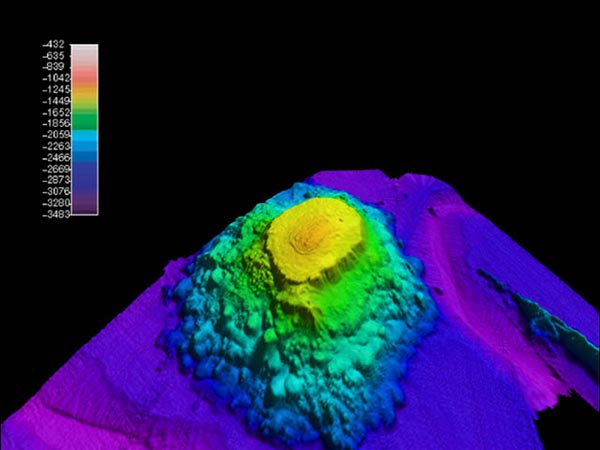
Multibeam image of Denson Seamount, looking approximately northwest
Location
Location North Pacific Ocean
Coordinates 54°03′34″N 137°25′01″W / 54.0594°N 137.4170°W / 54.0594; -137.4170Coordinates: 54°03′34″N 137°25′01″W / 54.0594°N 137.4170°W / 54.0594; -137.4170
Country United States
Geology
Type Submarine volcano
Volcanic arc/chain Kodiak-Bowie Seamount chain
Age of rock 18 million years old

Denson Seamount is a submarine volcano in the Kodiak-Bowie Seamount chain, with an estimated age of 18 million years.[1] It lies at the southern end of the chain near the Canada-United States border. It was one of the underground volcanic extrusions investigated by the 2004 Gulf of Alaska Seamount Expedition.[2] The expedition's goal was:

"Our goal was to gain an understanding of the geologic histories of the five previously unexplored seamounts in the Gulf of Alaska. To achieve this we created a full-coverage swath bathymetry map of each seamount and its surroundings, and we collected rock samples at all possible depths." -Randy Keller, Oregon State University[3]

On August 6, 2004, the DSV Alvin dropped down near the Desmon Seamount and collected basaltic rock to try to determine the age of the seamount. The search was difficult because the salty water had altered the volcanic rock over time, but they determined in lab tests that the Denson Seamount was about 18 million years old. The team used bathymetric mapping to render three-dimensional images of the Denson Seamount and its counterparts.

References

External links


Wikimedia Foundation. 2010.

Игры ⚽ Нужно сделать НИР?

Look at other dictionaries:

  • Kodiak-Bowie Seamount chain — The Kodiak Bowie Seamount chain, also called the Pratt Welker Seamount chain, is a seamount chain in southeastern Gulf of Alaska stretching from the Aleutian Trench in the north to Bowie Seamount, the youngest volcano in the chain, which lies 180 …   Wikipedia

  • Peirce Seamount — Infobox Seamount Name=Peirce Seamount Location map British Columbia| label=Peirce Seamount mark=RedMountain.svg|marksize=18 lat deg=53|lat min=44|lat dir=N lon deg=136|lon min=32|lon dir=W position=left |float=right caption=Location of Peirce… …   Wikipedia

  • Tiefseeberg — Denson Seamount im Pazifik, nahe der Staatsgrenze zwischen den USA und Kanada Kette der N …   Deutsch Wikipedia

  • Liste des monts sous-marins de l'océan Pacifique — En raison de l intense activité volcanique et tectonique de cette partie du monde, un part significative des monts sous marins connus dans le monde sont situés dans l océan Pacifique, souvent isolés, parfois groupés comme les monts sous marins de …   Wikipédia en Français

  • Portal:Atlantic Archipelagoes — Wikipedia portals: Culture Geography Health History Mathematics Natural sciences People Philosophy Religion Society Technology …   Wikipedia

  • Portal:Cape Verde — Wikipedia portals: Culture Geography Health History Mathematics Natural sciences People Philosophy Religion Society Technology …   Wikipedia

  • Mont sous-marin — Un mont sous marin est une montagne ou un ancien volcan s élevant depuis le fond de la mer mais sans atteindre la surface de l océan (sinon on parle plutôt d île). Carte des principaux monts sous marins Ces monts sont restés longtemps méconnus,… …   Wikipédia en Français

Share the article and excerpts

Direct link
Do a right-click on the link above
and select “Copy Link”