Deichselbach

Deichselbach

Template:Infobox Fluss/Catchment area missingTemplate:Infobox Fluss/Discharge missing

Deichselbach
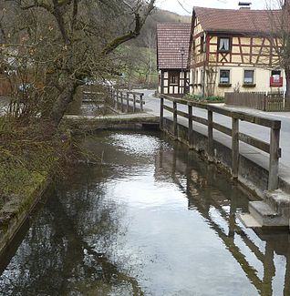
The Deichselbach in Frankendorf

The Deichselbach in Frankendorf

DataTemplate:Infobox Fluss/Map missing
Location Upper Franconia, Bavaria,  Germany
Reference no. DE: 242912
Length 11.5 km Template:Infobox Fluss/NACHWEIS-LÄNGE missing
Source by the village Tiefenhöchstadt in the community of Buttenheim Template:Infobox Fluss/QUELLKOORDINATE missing
Source height ca. 477 m above sea level
Mouth by Altendorf into the RegnitzTemplate:Infobox Fluss/Mouth coordinates missing
Mouth height ca. 245 m above sea level
Descent ca. 232 m
Basin Rhine
Progression Regnitz → Main → Rhine → North Sea

The Deichselbach is a stream in Upper Franconia, Germany. It is about 11.5 kilometers long.

Course

The Deichselbach has its source east of the village Tiefenhöchstadt in the community of Buttenheim. In Altendorf, the stream passes under the Rhine–Main–Danube Canal and then flows into the Regnitz.

The stream runs through the following places:

External Links

This article incorporates information from the German Wikipedia.

Coordinates: 49°48′N 11°01′E / 49.8°N 11.017°E / 49.8; 11.017


Wikimedia Foundation. 2010.

Игры ⚽ Поможем сделать НИР

Look at other dictionaries:

  • Deichselbach — Gewässerkennzahl DE: 242912 Lage Oberfranken, Bayern, Deutschland Flusssystem RheinVorlage:Infobox F …   Deutsch Wikipedia

  • Дайксельбах — нем. Deichselbach …   Википедия

  • Dreuschendorf — Markt Buttenheim Koordinaten …   Deutsch Wikipedia

  • Список рек Германии —   Это служебный список статей, созданный для координации работ по развитию темы.   Данное предупреждение не ус …   Википедия

  • Dreuschendorf — is a small village located in Bavaria, Germany. It is in Upper Franconia, in the Bamberg district. Dreuschendorf is a constituent community of Buttenheim. In 2007, the village had a population of 327.[1] Contents 1 Geography 2 History …   Wikipedia

  • Höfstetten (Heilsbronn) — Höfstetten Stadt Heilsbronn Koordinaten …   Deutsch Wikipedia

  • Markttriebendorf — Stadt Heilsbronn Koordinaten …   Deutsch Wikipedia

  • Regnitz — als westliche Begrenzung der Fränkischen Schweiz Daten …   Deutsch Wikipedia

  • Tiefenhöchstadt — is a small village located in Bavaria, Germany. It is in Upper Franconia, in the Bamberg district. Tiefenhöchstadt is a constituent community of Buttenheim. In 2007, the village had a population of 90.[1] Contents 1 Geography 2 History …   Wikipedia

  • Tiefenhöchstadt — Gemeinde Buttenheim Koordinaten …   Deutsch Wikipedia

Share the article and excerpts

Direct link
Do a right-click on the link above
and select “Copy Link”