- Decatur Waterworks
-
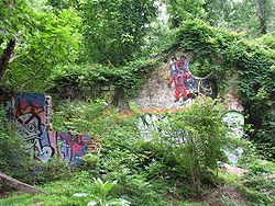
The Decatur Waterworks was a facility that obtained drinking water for the city of Decatur, Georgia, from the local Peachtree Creek. Abandoned since the 1940s, the Waterworks have fallen into disrepair and are covered with graffiti. The Decatur Waterworks, referred to locally as "The Ruins,"[citation needed] are now located in Mason Mill Park, near the city of Decatur. The facilities were built in 1906.
Historical Designation
On March 15, 2006, the Decatur Waterworks was designated by the State of Georgia as a historical site, due to its former industrial significance.
The Decatur Waterworks was nominated as a historic location by the Georgia state government based on engineering and its significance in landscape architecture and politics.
A Brief History of the Decatur Water Works
Near Decatur Georgia, before the Civil War, in the 1850s, Ezekiel Mason built a flour mill on the bank of Burnt Fork Creek near where it flows into the south fork of Peachtree Creek. This is the mill from which Mason Mill Road and Mason Mill Park derive their names. After the deaths of Mr. Mason and his wife in the late 19th century the land was inherited by their nephew, James Mason. James Mason sold the property to the City of Decatur in the early 20th century.
In 1906 the City of Decatur built the first public water system in the area on this land. The Decatur Water Works consisted of two aeration and solid removal tanks, two storage tanks, an office building and two dams, one dam on South Peachtree Creek and one on Burnt Fork Creek. The remains of all of these structures can still be seen today and are often referred as ‘the old Decatur Water Works’ or sometimes simply ‘the ruins’.
The Decatur Water Works supplied water to the city until the 1940s. In the 1930s a Works Progress Administration (WPA) project built a number of recreational amenities on the site to support the use of the grounds and lakes as a public park. These amenities included granite benches, cooking grills, tables and a stone bridge over Burnt Fork Creek. These things also can be seen today. The stone bridge is part of the new trail that has been recently constructed in the park. The WPA also built a stacked stone fountain that remains and can be seen very near the stone bridge.
By 1941 it was apparent the 1.8 million US gallons (6,800 m3) of water per day produced by the water works was no longer enough to satisfy the growing needs of Decatur. The property was leased to DeKalb County, which operated the water works and sold the water to Decatur. DeKalb used revenue from the facility to fund a county-wide treatment plant in the Dunwoody area that uses water from the Chattahoochee River. Initially called the Laurel Plant, it is now called the Scott Candler Plant after the county commissioner who led the development process.
During WWII the Decatur Water Works was used as the exclusive water supply for the Naval Air Station that is now Peachtree DeKalb Airport and an Army Hospital in the area. The property was declared off limits for civilian use and was not used for any recreational purpose or as a civilian water supply during the war. At the end of the war the water works land was returned to the county, but was not used to supply water.
For a time the office building at the water works was used for storage by the county. In 1951 a bond issue to finance development of the land was voted down. The water works fell into disuse and disrepair. By the mid-1960s the lakes had begun to fill with silt and there were complaints of flooding from local residents who lived in the adjacent neighborhoods that were built in the 1950s and 1960s. In about 1965 the dams were dynamited and the reservoirs drained.
In 1988 the county worked with local resident groups to make a development plan for Mason Mill Park that included the water works land, but the plan was never funded. In 2006 the Decatur Water Works was declared a historic site by the state of Georgia. A second plan was developed in 2008 and, with partial funding from the PATH Foundation, is being implemented. This plan and the 1988 plan can be seen on the DeKalb County web site (http://www.co.dekalb.ga.us/parks/pr-mason-mill-park.html).
A historical image of the water works can be found here
http://www.co.dekalb.ga.us/parks/pdf/OldDecaturHistoricWaterWorks.pdf
References
Categories:- Buildings and structures in DeKalb County, Georgia
- Parks in Atlanta, Georgia
- Decatur, Georgia
Wikimedia Foundation. 2010.

