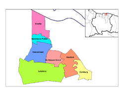
Wanica — Distrito de Surinam Capital Lelydorp … Wikipedia Español
Districts of Suriname — Suriname This article is part of the series: Politics and government of Suriname Constitution President … Wikipedia
Commewijne District — Map of Suriname showing Commewijne district Commewijne is a district of Suriname, located on the right bank of the Suriname River. Commewijne s capital city is Nieuw Amsterdam. Alliance is another major town. The district has a population of… … Wikipedia
Coronie District — Map of Suriname showing Coronie district Coronie is a district of Suriname, situated on the coast. Coronie s capital city is Totness, with other towns including Corneliskondre, Friendship, Jenny. The district border the Atlantic Ocean to the… … Wikipedia
Marowijne District — Map of Suriname showing Marowijne district Marowijne is a district of Suriname, located on the north east coast. Marowijne s capital city is Albina, with other towns including Moengo and Wanhatti. The district borders the Atlantic Ocean to the… … Wikipedia
Nickerie District — Map of Suriname showing Nickerie district Nickerie is a district of Suriname, on the north west coast. Nickerie s capital city is Nieuw Nickerie, the second largest city in the country. Other towns include Washoda and Wageningen. The district… … Wikipedia
Saramacca District — Coordinates: 5°46′57″N 55°37′29″W / 5.7825°N 55.62472°W / 5.7825; 55.62472 … Wikipedia
Wanica District — Wanica is a district of Suriname, in the northeast. Wanica s capital city is Lelydorp. Wanica has a population of near 76,320 and an area of 444 km². With a high population density, Wanica is one of Suriname s most populated and most urbanised… … Wikipedia
Moengo — Resort Map showing the resorts of Marowijne District … Wikipedia
Lelydorp — is the capital city of Wanica district, located in Suriname. With a population of almost 19.000, it is the second city in Suriname, after Paramaribo. [ [http://world gazetteer.com/wg.php?x= men=gcis lng=en dat=32 geo= 199 srt=n2pn col=ohq| World… … Wikipedia
 Suriname

