- Dazhi Station
-
Dazhi Station
(Shih Chien University)大直站
(實踐大學)Dazhi Station Platform Level Location Municipality Taipei District(s) Zhongshan Address 534-1 Bei-an Road Info Type Underground History Opened July 4, 2009 Rail services Line(s) ■ Neihu Line (B1) Daily Ridership 12,161 (Jul. 2011)[1]
(Ranked 72nd of 89)Operator(s) Taipei Rapid Transit System  There is a bus stop near this station.
Dazhi Station Chinese 大直站 Transcriptions Mandarin - Bopomofo ㄉㄚˋ ㄓˊ ㄓㄢˋ The Taipei Metro Dazhi Station is located in the Zhongshan District in Taipei, Taiwan. It is a station of the Neihu Line.
Contents
Station overview
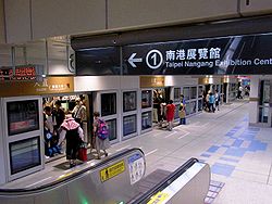
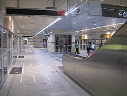
This underground station features an island platform, three exits, and a platform elevator located on the south side of the concourse level.[2] This station, along with Songshan Airport Station are the only medium-capacity stations on the Taipei Metro which are located underground. They are also the first underground stations in the system to have platform doors.
The platform level is 159 meters long. The platform itself is 83 meters long and 17.86 meters wide.[3]
The theme for this station is "Landscape".[3]
History
- May 23, 2002: Construction begins on Dazhi Station.[3]
- April 28, 2008: Construction is completed.[3]
- July 4, 2009: Begins service with opening of Neihu Line.
Station layout
1F Street Level Entrance/Exit B1 Concourse Lobby, information desk, one-way ticket machine, toilets B2 Platform 1 ← Neihu Line toward Taipei Nangang Exhibition Center (Jiannan Road) Island platform, Doors will open on the left Platform 2 → Neihu Line toward Taipei Zoo (Songshan Airport) → Exits
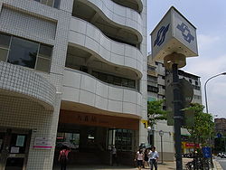
- Exit 1: Da-zhi St. (Da-zhi Community)

- Exit 2: Intersection of Bei-an and Da-zhi St.
- Exit 3: Intersection of Bei-an and Da-zhi St.[2]

References
- ^ "Passenger Volume at Taipei Rapid Transit Stations". Taipei City Department of Transportation. 2011-08-24. http://tcgwww.taipei.gov.tw/site/tcg/public/MMO/dot/m17.pdf. Retrieved 2011-08-24.
- ^ a b "Route Map: Dazhi". Department of Rapid Transit Systems, TCG. 2009-06-30. http://www.trtc.com.tw/e/stationdetail.asp?ID=021. Retrieved 2009-07-10.[dead link]
- ^ a b c d "Route Map: 大直站". East District Project Office, Department of Rapid Transit Systems. 2009-05-21. http://www.edpo.dorts.gov.tw/cgi-bin/SM_theme?page=4945ca0a. Retrieved 2009-07-17.[dead link]
Preceding station Taipei Metro Following station Jiannan Roadtoward Taipei Nangang Exhibition CenterBrown Line Songshan Airporttoward Taipei ZooTaipei Metro Brown Line (Neihu Line ↔ Wenshan Line) Taipei Nangang Exhibition Center - Nangang Software Park - Donghu - Huzhou - Dahu Park - Neihu - Wende - Gangqian - Xihu - Jiannan Road - Dazhi - Songshan Airport - Zhongshan Junior High School - Nanjing East Road - Zhongxiao Fuxing - Daan - Technology Building - Liuzhangli - Linguang - Xinhai - Wanfang Hospital - Wanfang Community - Muzha - Taipei Zoo
Coordinates: 25°04′47″N 121°32′49″E / 25.079596°N 121.546903°ECategories:- Taipei Metro stations in Taipei
- Railway stations opened in 2009
- Taiwan rapid transit stubs
Wikimedia Foundation. 2010.


