- Nantucket Shoals
-
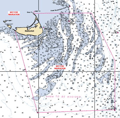 Detail from NOAA nautical chart 12300 showing the Nantucket Shoals in relation to Nantucket Island.
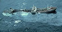
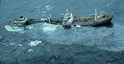
Nantucket Shoals is an area of dangerously shallow water in the Atlantic Ocean that extends from Nantucket Island, Massachusetts, eastward for 23 miles (37 km) and southeastward for 40 miles (64 km); in places water depth can be as shallow as 3 feet (0.91 m).[1] Depth soundings are unpredictable due to constant change from strong currents. The shoals lie just off a major transatlantic shipping lane. Numerous ships have been wrecked here, most recent and notably the oil tanker Argo Merchant in December 1976. Until 1983, the edge of the shoals was guarded by the Nantucket Lightship.
Nantucket Shoals is made up of the following features:[2]
- Asia Rip
- Davis Bank
- Fishing Rip
- Middle Rip
- Phelps Bank
According to the 2010 edition of the United States Coast Pilot, the International Maritime Organization has established an "area to be avoided" for the Nantucket Shoals. Vessels transporting oil or hazardous materials and vessels of more than 1,000 gross tons should avoid the area bounded by the following points (Note: not for navigational use):[1]
Point Coordinates
(links to map & photo sources)Notes Madaket 41°16′30″N 70°12′30″W / 41.275°N 70.208333°W Southwest point 40°43′12″N 70°00′30″W / 40.72°N 70.008333°W Near Asia Rip 40°44′30″N 69°19′00″W / 40.741667°N 69.316667°W Near Fishing Rip 41°04′30″N 69°19′00″W / 41.075°N 69.316667°W Northeast point 41°23′30″N 69°31′30″W / 41.391667°N 69.525°W Great Point Light 41°23′24″N 70°02′48″W / 41.39°N 70.046667°W References
- ^ a b United States Coast Pilot. 2 (39th ed.). Washington, D.C.: National Ocean Service. 2010. pp. 178–179. http://www.nauticalcharts.noaa.gov/nsd/coastpilot_w.php?book=2. Retrieved April 17, 2010.
- ^ United States Coast Pilot. 2 (39th ed.). Washington, D.C.: National Ocean Service. 2010. pp. 179–180. http://www.nauticalcharts.noaa.gov/nsd/coastpilot_w.php?book=2. Retrieved April 17, 2010.
External links
- "Nantucket Shoals". Geographic Names Information System, U.S. Geological Survey. http://geonames.usgs.gov/pls/gnispublic/f?p=gnispq:3:::NO::P3_FID:600157.
- "A Fine Load of Codfish: Caught on the Rough Nantucket Shoals" (PDF). The New York Times. June 23, 1878. http://query.nytimes.com/mem/archive-free/pdf?res=9B0CEED7173EE63BBC4B51DFB0668383669FDE. Retrieved April 17, 2010.
Categories:- Landforms of the Atlantic Ocean
- Landforms of Nantucket County, Massachusetts
- Nantucket, Massachusetts
- Massachusetts stubs

Wikimedia Foundation. 2010.