- Dale Enterprise, Virginia
-
Dale Enterprise, Virginia — Unincorporated community — 
 Dale Enterprise, Virginia
Coordinates: 38°27′18″N 78°56′20″W / 38.455°N 78.93889°WCoordinates: 38°27′18″N 78°56′20″W / 38.455°N 78.93889°W Country United States State Virginia County Rockingham Elevation 1,408 ft (429 m) Time zone Eastern (EST) (UTC-5) – Summer (DST) EDT (UTC-4) Area code(s) 540 GNIS feature ID 1492833[1] Dale Enterprise is an unincorporated community in Rockingham County, Virginia, United States.
Contents
Geography
Dale Enterprise is located at latitude 38.455 N and longitude 78.939 W in the Shenandoah Valley, approximately four miles west of the City of Harrisonburg along U. S. Highway 33 (the Rawley Pike).[2],[3],[4] The community is shown on the Bridgewater U.S. Geological Survey Map and is in the Eastern time zone.[5][6]
Dale Enterprise sits at an elevation of 1408 feet, on the northeastern foot of the 1898-foot high Mole Hill, an igneous intrusion that is believed to have been the core of a volcano that has eroded away over the years.[7]
Climate
Monthly Climate Summary for Dale Enterprise, Virginia[8]
Period of Record: January, 1893 – December, 2009
Jan Feb Mar Apr May Jun Jul Aug Sep Oct Nov Dec Annual Average Max. Temperature (F) 43.3 45.5 55.3 65.5 74.8 82.3 85.8 84.2 78.5 67.7 55.7 45.4 65.3 Average Min. Temperature (F) 22.3 23.3 30.7 39.0 48.5 56.8 60.9 59.5 53.1 41.9 32.7 24.7 41.1 Average Total Precipitation (in.) 2.32 2.13 2.84 2.71 3.62 3.85 4.16 3.89 3.19 2.63 2.28 2.39 36.01 Average Total SnowFall (in.) 7.2 7.2 4.3 1.1 0.0 0.0 0.0 0.0 0.0 0.2 1.3 4.6 25.8 Average Snow Depth (in.) 1 1 0 0 0 0 0 0 0 0 0 1 0 History
Dale Enterprise is at the northern edge of “The Burnt District,” an area in which in early October, 1864, during the American Civil War, Union General Philip Sheridan ordered all of the houses to be burned in retribution for the death of a young staff officer, Lieutenant John Rodgers Meigs. Lt. Meigs was mortally wounded by Confederate cavalry scouts a couple miles southeast of Dale Enterprise on October 3, 1864. Many families in the Dale Enterprise vicinity lost their homes, farm buildings, and livestock in the ensuing destruction, despite the fact that most of the area families were pacifist Mennonites.[9]
Dale Enterprise Weather Station
Lewis “L. J.” Heatwole, the son of David and Catherine Driver Heatwole, started keeping a weather diary at his parents’ farm in Dale Enterprise in 1868 at the age of 15. In 1884, the U.S. Signal Service designated Heatwole as a "voluntary observer." Four years later, Heatwole set up the Dale Enterprise weather station.
The Dale Enterprise station is the oldest operating weather station in Virginia and the third oldest in the nation, and has been operated by the same family since its founding. The station is located in a farm field, “well away from buildings or hard surfaces.” As of early 2010, the station’s original thermometer remained as a back-up to an electronic temperature sensor installed in 1994.[10][11]
Blosser Printing Press
The Blosser Printing Press was established by Abraham Blosser in the late 19th century in his home near Dale Enterprise. His main publication at the press is noted as the Watchful Pilgrim, a semimonthly paper he edited and printed for several years, starting in 1880. David Taylor was the typesetter. The press also ran a tract concerning Mennonite baptism practices – Eine Verhandlung von den äusserlichen Wasser-Taufe (Harrisonburg, Virginia, 1816) originally written in German by Peter Burkholder. In addition, Blosser printed his own tracts and did custom work.[12]
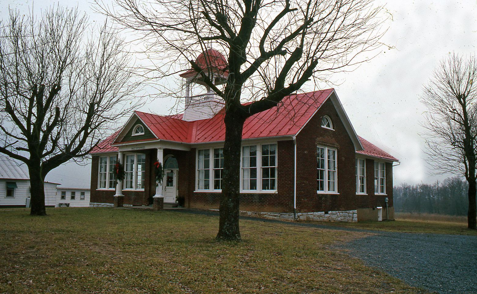
Dale Enterprise School
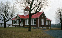 Dale Enterprise School, Dale Enterprise, VA
The history of the Dale Enterprise School dates to 1877 when Peter and Nancy Heatwole deeded about half an acre of their farm to Rockingham County for a school. The frame Piney Grove School was built on the property in 1885, in a pine grove next to the H & R Springs Turnpike, later to become U.S. Highway 33.
In the summer of 1909, the County school board razed the Piney Grove schoolhouse and built the new Dale Enterprise School on the property. A 1914 County schools history refers to the new school as "a beautiful three-room brick house," and notes that "[t]he house is supplied with water from the Harrisonburg mains, and is modern except its lack of sanitary toilets."[13] The school included grades 1-7. Each of the three classrooms had “combined classes."
After the school closed in 1963, the building stood vacant until 1975, but since then has served several uses, including its present use as the Harrisonburg Unitarian Universalist Fellowship’s church.[14],[15]
References
- ^ U.S. Geological Survey Geographic Names Information System: Dale Enterprise, Virginia
- ^ “US Board on Geographic Names,” United States Geological Survey, 01-05-2009. http://geonames.usgs.gov. Retrieved 2010-09-11.
- ^ Harrionsburg, Virginia, United States Department of the Interior, 1943. http://historical.mytopo.com/quad.cfm?quadname=Harrisonburg&state=VA&series=15. Retrieved 2010-08-18.
- ^ MapQuest, http://www.mapquest.com/maps?1c=Dale+Enterprise&1s=VA&1y=US&1l=38.454399&1g=-78.939697&1v=CITY&2c=Harrisonburg&2s=VA&2y=US&2l=38.449402&2g=-78.869202&2v=CITY. Retrieved 2010-09-17.
- ^ Bridgewater, Virginia, United States Department of the Interior, 2002
- ^ VA HomeTownLocator, http://virginia.hometownlocator.com/VA/Rockingham/Dale-Enterprise.cfm. Retrieved 2010-09-12.
- ^ “A Brief Geologic History of Rockingham County,” W. Cullen Sherwood. http://csmres.jmu.edu/geollab/vageol/outreach/fieldtrips/rockin, Retrieved 2010-08-18.
- ^ Dale Enterprise, Virginia (442208), Period of Record Monthly Climate Summary, Western Regional Climate Center. http://www.wrcc.dri.edu/cgi-bin/cliRECtM.pl?va2208. Retrieved 2010-08-16.
- ^ John L. Heatwole, The Burning: Sheridan’s Devastation of the Shenandoah Valley (Charlottesville, Virginia, Rockbridge Publishing, 1998), pp. 89-114.
- ^ “Co-Op Spotlight … The Oldest Station in the State,” Melody Paschetag, Sterling Reporter, Spring 2002. http://www.erh.noaa.gov/lwx/reporter/index.htm, 2002-04-11. Retrieved 2010-08-16.
- ^ “Weather’s in Their Blood,” Staunton Mennonite Church, reprinted from the Daily News-Record (“Single Family Runs Dale Enterprise Station for More than 125 Years,” Heather Bowser), 05-14-2009. http://www.mennochurch.net/weatherman.htm. Retrieved 2010-08-16.
- ^ “Blosser's Printing Press (Dale Enterprise, Virginia, USA),” Harry A. Brunk, Global Anabaptist Mennonite Encyclopedia Online, 1953. http://www.gameo.org/encyclopedia/contents/B573.html. Retrieved 2010-08-15.
- ^ Superintendent George Hulvey quoted in “The Dale Enterprise Schoolhouse and HUU,” Chris Edwards, 2000 (updated 2009-07 from article printed in the HUU Review), http://huuweb.org/history.html. Retrieved 2010-12-04.
- ^ “Dale Enterprize [sic] School,” included with “History of Rockingham County Public Schools” (originally included in an article "History of Rockingham County Schools," Faye Reubush and Dorothy Swank, VEA Centennial Celebration, 1963; updated Larry Huffman, 2001), http://www.rockingham.k12.va.us/rcps_history/daleenterprize.htm. Retrieved 2010-12-04.
- ^ “The Dale Enterprise Schoolhouse and HUU,” Chris Edwards, 2000 (updated 2009-07 from article printed in the HUU Review), http://huuweb.org/history.html. Retrieved 2010-12-04.
Municipalities and communities of Rockingham County, Virginia Towns Bridgewater | Broadway | Dayton | Elkton | Grottoes‡ | Mount Crawford | Timberville

CDPs Belmont Estates | Massanetta Springs | Massanutten
Unincorporated
communitiesBergton | Berrytown | Briery Branch | Clover Hill | Cootes Store | Criders | Cross Keys | Dale Enterprise | Edom | Fulks Run | Hinton | Inglewood | Keezletown | Lacey Spring | Linville | Lilly | Mauzy | Mayland | McGaheysville | Mechanicsville | Montezuma | Mount Clinton | Ottobine | Penn Laird | Pleasant Valley | Port Republic | Rawley Springs | Singers Glen | Stemphleytown | Tenth Legion | Turleytown | Yankeetown
Footnotes ‡This populated place also has portions in an adjacent county or counties
Categories:- Populated places in Rockingham County, Virginia
- Unincorporated communities in Virginia


Wikimedia Foundation. 2010.