- Dalderby
-
Coordinates: 53°10′32″N 0°07′57″W / 53.17547700°N 0.13236769°W
Dalderby 
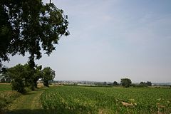
View across farmland from Dalderby
 Dalderby shown within Lincolnshire
OS grid reference TF249658 Parish Roughton District East Lindsey Shire county Lincolnshire Region East Midlands Country England Sovereign state United Kingdom Post town Horncastle Postcode district LN9 Police Lincolnshire Fire Lincolnshire Ambulance East Midlands EU Parliament East Midlands UK Parliament Louth and Horncastle List of places: UK • England • Lincolnshire Dalderby is a village about 3 miles (4.8 km) south of Horncastle, Lincolnshire, England, in the civil parish of Roughton.
Dalderby once had a parish church dedicated to Saint Martin; it was demolished in 1742, possibly because of a decline in village population.[1]
Teapot Hall was a triangular one roomed cottage with a thatched roof. In 1945 it was burnt down, perhaps during end of World War II celebrations. Nothing remains today.[2]
Manor Farmhouse, dating from the 17th century, has a thatched roof, and dado paneling inside the building that reputedly came from the old church.[3]
References
- ^ "Site of St Martin's church, Dalderby". Lincolnshire Archives. http://www.lincstothepast.com/SITE-OF-ST-MARTIN-S-CHURCH--DALDERBY/226871.record?pt=S. Retrieved 19 June 2011.
- ^ "Teapot Hall". English Heritage National Monuments Record. http://www.pastscape.org.uk/hob.aspx?hob_id=1489449&sort=4&search=all&criteria=Dalderby&rational=q&recordsperpage=10. Retrieved 19 June 2011.
- ^ "Manor Farm House, Roughton". British Listed Buildings. http://www.britishlistedbuildings.co.uk/en-195216-manor-farm-house-roughton. Retrieved 19 June 2011.
Categories:- Lincolnshire geography stubs
- Villages in Lincolnshire
- East Lindsey
Wikimedia Foundation. 2010.

