Cwm Head

Cwm Head

Coordinates: 52°29′35″N 2°51′00″W / 52.493°N 2.85°W / 52.493; -2.85

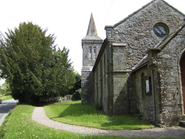
St. Michael's and All Angels church, Cwm Head (by Jonathan Billinger)

Cwm Head is a hamlet in Shropshire, England. The name is part-Welsh, part-English and means "Head of the Valley".

It is located in the parish of Wistanstow and on the B4370 road, 1¼ miles (1.9km) southwest of Marshbrook and the A49 road. From Cwm Head, the B4370 heads downhill both towards Marshbrook and in the other direction towards Horderley and the A489.

There is a church at Cwm Head - "St Michael and All Angels".[1] It was built in 1845 to a neo-Norman design by H. C. Whitling and is built largely of stone.[2]

To the northwest is the hamlet of Hamperley while to the northeast (towards Marshbrook) is the hamlet of Whittingslow.

The hamlet lies between 226m and 232m above sea level.

References

  1. ^ Geograph Cwm Head and the church of St Michael and All Angels
  2. ^ A Guide to Shropshire (Third Edition), 2005, Raven, p. 68

Wikimedia Foundation. 2010.

Игры ⚽ Нужно сделать НИР?

Look at other dictionaries:

  • Cwm Idwal — and Llyn Idwal Cwm Idwal is a hanging valley in the Glyderau range of mountains in northern Snowdonia, the national park in the mountainous region of North Wales. Its main interest is to hill walkers and rock climbers, but it is also of interest… …   Wikipedia

  • Cwm yr Eglwys — is a hamlet located at a picturesque cove on the North side of Dinas Head peninsula, in the community of Dinas Cross between Fishguard and Newport, Pembrokeshire, in southwest Wales.There is a small beach with safe bathing, a narrow slipway for… …   Wikipedia

  • Cwm Nantcol — is a valley in the Ardudwy area of the county of Gwynedd in Wales. It lies in the Rhinogydd range of mountains in Snowdonia and carries the Afon Cwmnantcol. At the head of Cwn Nantcol is the Bwlch Drws Ardudwy pass, from where it is possible to… …   Wikipedia

  • Cwm Ystwyth — Infobox UK place country = Wales welsh name = Cwm Ystwyth constituency welsh assembly = official name = Cwm Ystwyth latitude = 52.35208 longitude = 3.79177 unitary wales = Ceredigion lieutenancy wales = Dyfed constituency westminster = Ceredigion …   Wikipedia

  • Cwm Penmachno — Coordinates: 53°00′32″N 3°51′44″W / 53.0088°N 3.8623°W / 53.0088; 3.8623 …   Wikipedia

  • Cwm-yr-Eglwys — St. Brynach s Church St Brynach s church prior to 1831 …   Wikipedia

  • cwm — noun /kuːm/ A valley head created through glacial erosion and with a shape similar to an amphitheatre. Syn: cirque, coombe, corrie …   Wiktionary

  • Ysgol Gyfun Cwm Rhymni — Infobox UK school name = Ysgol Gyfun Cwm Rhymni imagesize = 10px latitude = longitude = dms = motto = Tua r Goleuni (Towards the Light) motto pl = established = 1981 approx = closed = c approx = type = State School religion = president = head… …   Wikipedia

  • Llyn Cwm Bychan — Infobox lake lake name = Llyn Cwm Buchan image lake = Llyn Cwm Bychan.jpg caption lake = A narrow road leads to the single farm at the head of the valley. image bathymetry = caption bathymetry = location = North Wales coords = coord|52|51.7|N|4|1 …   Wikipedia

  • Everest, Mount — Tibetan Chomolungma Nepali Sagarmatha Peak on the crest of the Himalayas, southern Asia. The highest point on Earth, with a summit at 29,035 ft (8,850 m), it lies on the border between Nepal and Tibet (China). Numerous attempts to climb Everest… …   Universalium

Share the article and excerpts

Direct link
Do a right-click on the link above
and select “Copy Link”