Cumberworth

Cumberworth

Coordinates: 53°14′18″N 0°15′21″E / 53.238332°N 0.25578819°E / 53.238332; 0.25578819

Cumberworth
St.Helen's church - geograph.org.uk - 1161472.jpg
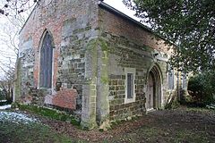
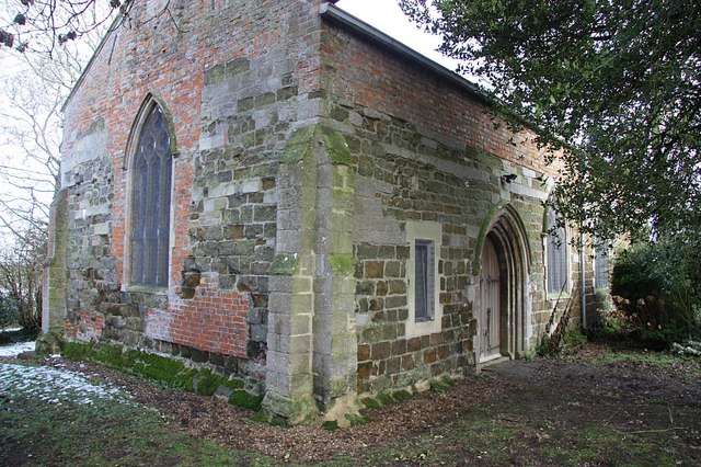
St Helen's church, Cumberworth
Cumberworth is located in Lincolnshire
Cumberworth

 Cumberworth shown within Lincolnshire
Population 128 (2001)
OS grid reference TF 50643 73630
Parish Cumberworth
District East Lindsey
Shire county Lincolnshire
Region East Midlands
Country England
Sovereign state United Kingdom
Post town Alford
Postcode district LN13
Police Lincolnshire
Fire Lincolnshire
Ambulance East Midlands
EU Parliament East Midlands
UK Parliament Louth and Horncastle
List of places: UK • England • Lincolnshire

Cumberworth is a small village and civil parish in the East Lindsey district of Lincolnshire, England, situated about 5 miles (8.0 km) south-east of Alford.

The village was mentioned in the Domesday Book as having nine households and 20 acres of meadow. The Lord of the Manor was Rainer of Brimeaux.[1]

The church was dedicated to St Helen and is a Grade II Listed Building.[2] It was declared redundant in 1987 and sold in 1989.[3]

References

  1. ^ "Cumberworth". Domesday Map. Anna Powell-Smith/University of Hull. http://www.domesdaymap.co.uk/place/TF5073/cumberworth/. Retrieved 25 June 2011. 
  2. ^ "Church of St Helen", National Heritage List for England, English Heritage; retrieved 20 July 2011
  3. ^ "Cumberworth". Genuki. http://www.genuki.org.uk/big/eng/LIN/Cumberworth/. Retrieved 22 April 2011. 

Wikimedia Foundation. 2010.

Игры ⚽ Нужно сделать НИР?

Look at other dictionaries:

  • Upper Cumberworth — is a small village in West Yorkshire, England that is situated between the villages of Denby Dale and Shepley, above the village of Lower Cumberworth. It occupies a rural location, surrounded by fields and woodland but within easy reach via… …   Wikipedia

  • Upper Cumberworth — Koordinaten …   Deutsch Wikipedia

  • Lower Cumberworth — is a village in the borough of Kirklees in West Yorkshire, England, to the south east of Huddersfield. The civil parish of Denby Dale covers the village. The parish council gave the population of the villages of Upper and Lower Cumberworth as… …   Wikipedia

  • Penistone Line — Overview Type Heavy rail System National Rail Status Operational Locale South Yorkshire West Yorkshire She …   Wikipedia

  • Denby Dale — Coordinates: 53°34′19″N 1°39′18″W / 53.572000°N 1.655000°W / 53.572000; 1.655000 …   Wikipedia

  • Shepley — infobox UK place country = England latitude= 53.58354 longitude= 1.71146 official name= Shepley map type= West Yorkshire population = civil parish= Kirkburton metropolitan borough= Kirklees metropolitan county= West Yorkshire region= Yorkshire… …   Wikipedia

  • Kirklees — For the medieval village of the same name, see Kirklees, West Yorkshire. Coordinates: 53°35′35″N 1°48′04″W / 53.593°N 1.801°W / 53.593; 1.801 …   Wikipedia

  • Marmaduke Constable — For others named Marmaduke Constable, see Constable Baronets. Sir Marmaduke Constable, the little (c.1458 – 20 November 1518) was an English soldier descended from the Hereditary Constables of Chester, hence the surname of the family. He… …   Wikipedia

  • Denby Dale — 53° 34′ 19″ N 1° 39′ 18″ W / 53.572, 1.655 Denby Dale (en français vallée de …   Wikipédia en Français

  • A52 road — UK road routebox road= A52 length mi= length km= direction= East West start= Newcastle under Lyme destinations= Stoke on Trent Ashbourne Derby Nottingham Grantham Boston Skegness end= Mablethorpe construction date= completion date= junctions=… …   Wikipedia

Share the article and excerpts

Direct link
Do a right-click on the link above
and select “Copy Link”