- Cuerden Hall
-
Coordinates: 53°42′36″N 2°39′44″W / 53.7100°N 2.6621°W
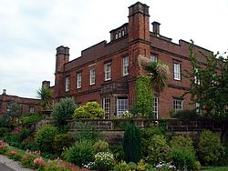
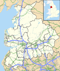
Cuerden Hall Cuerden HallLocation: Cuerden Valley Park near Preston, Lancashire, England OS grid reference: SD5639423929 Listed Building – Grade II* Designated: 21 February 1984 Reference #: 357614 Cuerden Hall is a country mansion in the village of Cuerden near Preston, Lancashire, England. It is a Grade II* listed building.[1] The Hall was formerly a family home between 1717 and 1906, and used by the Army up until the 1960s. It is now a Sue Ryder Care Home. The parkland and wider estate are known as Cuerden Valley Park.
History
The original house on the site, dating from the 17th century, no longer exists. The present building dates from 1717 and was erected by Banastre Parker, son of the former High Sheriff of Lancashire Robert Parker (1710). Upon his death in 1738 the estate passed to his son Robert Parker (1727–1779) and in turn to his grandchildren Banastre Parker (1758–1788) and Thomas Towneley Parker (1760–1794).[2]
The parapet above the front door - a carved stone coat of arms flanked by a carved stag and a hawk. The arms feature Parker quartering Towneley and impaling Brooke (In 1816 Robert Towneley-Parker (1793–1879) married Harriet Brooke (1798–1878), daughter of Thomas Brooke of Church Minshall, Cheshire).
In the years 1816 to 1819 Robert Towneley Parker (1793–1879), having inherited the estate from his father, remodelled the Hall according to the designs of Lewis Wyatt. This incorporated a significant extension to the east wing of the property.[3]
After the death of Capt. Robert Townley Parker (1823–1894) and later his brother Thomas Towneley Parker (1822–1906) the estate passed to their nephew Reginald Arthur Tatton (1857–1926)[4] who re-designed the gardens, introducing a pergola and gazebo, a walled garden and pond.[5]
During the First World War Tatton adapted the Hall for use as an infirmary for troops, and between 1 May 1915 and 8 June 1917 it was known as Cuerden Hall Auxiliary Hospital.[6] The drawing rooms, with the Tatton family’s collection of old masters and portraits still adorning the walls, were turned into wards and furnished with beds, bed linen and equipment,[5] whilst the parkland and gardens provided an area for convalescence for the soldiers, enjoying such activities as boating on the lake, haymaking, and picnicking. There were also trips to the Tatton family’s other house nearby, Astley Hall. An album filled with photographs, letters and news cuttings that tell this particular story in Cuerden Hall's history was recently offered for sale.[6]
During the Second World War, the estate was requisitioned by the Ministry of Defence and converted into an Army Education Centre and later became the British Army Divisional Headquarters (number four of five) of the Anti-Aircraft Command. By the late 1950s the Hall had been in use by the Army intermittently for a number of years and in 1958, after nearly 250 years of private family ownership, the Hall was finally sold by the Tatton family to the Ministry of Defence and it became the Army's Headquarters North West District.[5]
In 1977 the Central Lancashire Development Corporation took over the Hall from the Ministry of Defence and established its own Headquarters there,[7] in the process constructing new offices and car parks in the grounds. By 1978, the parkland and wider estate had been developed into Cuerden Valley Park and in 1986, following vacation of the building by the Corporation, work had started on converting the Hall into a Sue Ryder Care Home, its present occupiers.
References
- ^ "Cuerden Hall, Shady Lane", Heritage Gateway (English Heritage), http://www.heritagegateway.org.uk/Gateway/Results_Single.aspx?uid=357614&resourceID=5, retrieved 3 April 2011
- ^ "A Genealogical and Heraldic History of the Commoners of Great Britain and Ireland...Volume 1, pp. 116-117,", John Burke (Google Books), http://books.google.com/books?id=uo9AAAAAcAAJ&printsec=frontcover&dq=inauthor:john+inauthor:burke&hl=en&ei=lOq7TcPZMIaLswbB-sGJBg&sa=X&oi=book_result&ct=result&resnum=9&ved=0CE8Q6AEwCA#v=onepage&q&f=false, retrieved 30 April 2011
- ^ "Townships: Cuerden, A History of the County of Lancaster: Volume 6 (1911), pp. 23-29", William Farrer & J. Brownbill (editors) (British History Online), http://www.british-history.ac.uk/report.aspx?compid=53062, retrieved 30 April 2011
- ^ "Links – Genealogy, Reginald Arthur Tatton, of Cuerden.", “Links – Genealogy” (“Links – Genealogy”), http://genealogy.links.org/links-cgi/readged?/home/ben/camilla-genealogy/current+c-tatton93827+2-2-0-1-0, retrieved 25 April 2011
- ^ a b c "Cuerden Valley Park, History of the Park", Cuerden Valley Park Trust (Cuerden Valley Park Trust), http://www.cuerdenvalleypark.org.uk/history.htm, retrieved 25 April 2011
- ^ a b "Cuerden Hall, First World War History", The Citizen (Preston and Leyland Citizen), http://www.prestoncitizen.co.uk/news/southribble/bamberbridge/3817875.First_World_War_history_of_Cuerden_Hall_on_sale_/, retrieved 25 April 2011
- ^ "Central Lancashire Development Corporation records", Lancashire Record Office (The National Archives), http://www.nationalarchives.gov.uk/a2a/records.aspx?cat=055-ntc_1&cid=14#14, retrieved 30 April 2011
External links
- Cuerden Valley Park - official site
Categories:- Buildings and structures in Chorley
- Country houses in Lancashire
- Grade II* listed buildings in Lancashire
Wikimedia Foundation. 2010.


