- Cuckfield & Lucastes (electoral division)
-
Coordinates: 51°00′57″N 0°08′59″W / 51.01591°N 0.14969°W
Cuckfield & Lucastes 
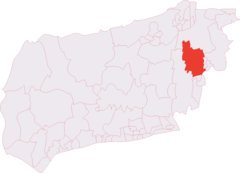
Shown within West SussexDistrict: Mid Sussex UK Parliament Constituency: Mid Sussex, Horsham Ceremonial county: West Sussex EU Constituency: South East England Electorate (2009): 8018 County Councillor Peter Bradbury (Con) Cuckfield & Lucastes is an electoral division of West Sussex in the United Kingdom, and returns one member to sit on West Sussex County Council.
Contents
Extent
The division covers the town of Cuckfield and the western part of the town of Haywards Heath; and the villages of Ansty, Staplefield and Whitemans Green.
It comprises the following Mid Sussex District wards: Cuckfield Ward and Haywards Heath Lucastes Ward; and of the following civil parishes: Ansty & Staplefield, Cuckfield and the western part of Haywards Heath.
Latest election result
The latest election in the division took place on 4 June 2009:
Cuckfield & Lucastes Party Candidate Votes % ±% Conservative Peter Bradbury 1,703 46.8 -14.5 Liberal Democrat Stephen Blanch 770 21.2 -17.5 Independent Mike Bright 644 17.7 +17.7 UKIP Marc Montgomery 218 6.0 +6.0 Green Catherine Edminson 208 5.7 +5.7 Labour Derek Davies 95 2.6 +2.6 Majority 933 25.6 +3.0 Turnout 3,638 45.4 0 Conservative hold Swing Previous election results
Results of the by-election held on 3 May 2007:
Cuckfield & Lucastes Party Candidate Votes % ±% Conservative Peter Bradbury 2,020 61.3 +8.3 Liberal Democrat Stephen Blanch 1,274 38.7 +7.4 Majority 746 22.6 +0.9 Turnout 3,358 45.4 -27.4 Conservative hold Swing
Results of the election held on 5 May 2005:Cuckfield & Lucastes Party Candidate Votes % ±% Conservative Mrs A M Morris 2,633 53.0 Liberal Democrat Mrs I Balls 1,556 31.3 Labour Mr D W Davies 423 8.5 Green Mr P B Wemyss-Gorman 354 7.1 Majority 1,077 21.7 Turnout 4,966 72.8 References
Election Results - West Sussex County Council
External links
Angmering and Findon · Arundel and Wick · Billingshurst · Bourne · Broadfield · Chichester North · Chichester South · Chichester West · Cissbury · Cuckfield and Lucastes · Durrington and Salvington · East Grinstead Meridian · East Grinstead South & Ashurst Wood · East Preston and Ferring · Felpham · Fernhurst · Fontwell · Goring · Gossops Green and Ifield East · Henfield · Holbrook · Hurstpierpoint & Bolney · Imberdown · Kingston Buci · Lancing · Lindfield and High Weald · Littlehampton Town · Maidenbower · Middleton · Midhurst · Northgate and Three Bridges · Nyetimber · Petworth · Pound Hill and Worth · Pulborough · Rustington · Saltings · Selsey · Shoreham · Sompting and North Lancing · Southgate and Crawley Central · Southwater and Nuthurst · Southwick · Storrington · The Witterings · Tilgate and Furnace Green · Warnham and Rusper · Worth Forest · Worthing WestLiberal Democrat Bersted · Bognor Regis East · Bognor Regis West & Aldwick · Bramber Castle · Broadwater · Burgess Hill East · Burgess Hill Town · Chichester East · Hassocks and Victoria · Haywards Heath East · Horsham Hurst · Horsham Riverside · Horsham Tanbridge & Broadbridge Heath · Littlehampton East · Northbrook · Roffey · Tarring · Worthing EastLabour Bewbush and Ifield West · Langley Green and West GreenIndependent Haywards Heath Town · Worthing Pier
This United Kingdom electoral unit article is a stub. You can help Wikipedia by expanding it.
