- Crow, Hampshire
-
Coordinates: 50°50′09″N 1°45′33″W / 50.8359°N 1.7591°W
Crow 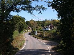
Moortown Lane, Crow
 Crow
Crow
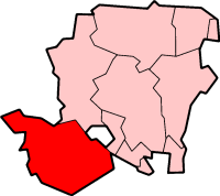
Crow shown within HampshireOS grid reference SU171041 Parish Ringwood District New Forest Shire county Hampshire Region South East Country England Sovereign state United Kingdom Post town RINGWOOD Postcode district BH24 Dialling code 01425 Police Hampshire Fire Hampshire Ambulance South Central EU Parliament South East England UK Parliament New Forest West List of places: UK • England • Hampshire Crow is a small village situated in the New Forest National Park in Hampshire, England. Its nearest town is Ringwood, which lies approximately 1 mile (1.6 km) north-west from the village.
History
The name "Crow" may be derived from an old Celtic word, either "criw" meaning "ford, weir", or perhaps "craw" meaning "hovel".[1] In the Domesday Book of 1086, Crow (Crone) was held by the sons of Godric Malf from the King.[2] In the 13th and 14th centuries the manor was held at various times by John de Burley, Sir Hugh Cheyne, Sir John Berkeley, and Humphrey Duke of Gloucester.[3] It was held by the Milbourne family in the 15th and 16th centuries until the death of Richard Milbourne in 1532.[3] It was sold to William Button in 1543, and the manor stayed in the Button family at least until 1599.[3] The manor subsequently passed to the Comptons of Minstead and Bisterne, and then with Bisterne to William Mills in 1792.[3] The two manors of Bisterne and Crow were effectively merged from that time.[3]
Notes
External links
 Media related to Crow, Hampshire at Wikimedia Commons
Towns, villages and hamlets in the New Forest District of Hampshire, England 
Allum Green | Applemore | Ashlett | Ashley | Ashurst | Bartley | Barton on Sea | Bashley | Beaulieu | Bisterne | Blashford | Blissford | Bolderwood | Boldre | Bramshaw | Bransgore | Breamore | Brockenhurst | Brook | Brookheath | Bucklers Hard | Burgate | Burley | Bull Hill | Cadnam | Calshot | Colbury | Copythorne | Crow | Damerham | Denny Lodge | Dibden | Dibden Purlieu | Downton | East Boldre | East End | East Hill | East Martin | East Mills | Emery Down | Ellingham | Everton | Exbury | Fawley | Fordingbridge | Fritham | Frogham | Furze Hill | Godshill | Gorley Lynch | Hale | Hale Park | Hale Purlieu | Hangersley | Harbridge | Hightown | Highwood | Hordle | Hungerford | Hyde | Hythe | Ibsley | Keyhaven | Lepe | Linbrook | Linford | Linwood | Lopshill | Lower Daggons | Lymington | Lyndhurst | Marchwood | Martin | Milford on Sea | Minstead | Mockbeggar | Netley Marsh | New Milton | Norley Wood | North Gorley | Ossemsley | Pennington | Picket Hill | Picket Post | Pilley | Portmore | Poulner | Ringwood | Rockbourne | Rockford | Sandford | Sandleheath | Shobley | Sopley | South Baddesley | South Gorley | Stuckton | Sway | Tinkers Cross | Tiptoe | Totton and Eling | Walhampton | Whitsbury | Whitsbury Common | Whitsbury Cross | Woodgreen | Woodlands
Categories:- Hampshire geography stubs
- New Forest
- Villages in Hampshire


Wikimedia Foundation. 2010.