Crooked River Gorge

Crooked River Gorge
Crooked River Gorge
Canyon
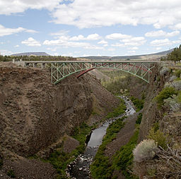
Bridges crossing Crooked River Gorge
Country United States
State Oregon
County Jefferson County, Oregon
Prominence 500 m (1,640 ft)
Coordinates 44°25′00″N 121°13′52″W / 44.4167°N 121.2310°W / 44.4167; -121.2310
Length 15 km (9 mi)

Crooked River Gorge is a 500-foot-deep (150 m) gorge located around Warm Springs and Smith Rock State Park, Central Oregon, United States. The gorge is surrounded by 400-foot (120 m) cliffs filled with a variety of wildlife. The upper part of the Crooked River Gorge, which are also popular among climbers, are made of columnar basalt cliffs eroded by the Crooked River since the Newberry volcanic eruption 1.2 million years ago.[1]

References

  1. ^ Dunegan, Lizann (2009). Best Easy Day Hikes Bend and Central Oregon, Falcon, 2nd ed. p. 25, ISBN 0762751037

External links


Wikimedia Foundation. 2010.

Игры ⚽ Нужен реферат?

Look at other dictionaries:

  • Crooked River — may refer to one of several places or things: Places In Canada Crooked River (British Columbia) Crooked River Provincial Park In New Zealand Crooked River (New Zealand) In the United States Crooked River (Florida) Crooked River (Georgia) Crooked… …   Wikipedia

  • Crooked River High Bridge — Crooked River (High) Bridge Carries U.S. Highway 97 Crosses Crooked River Locale Jefferson County, Oregon …   Wikipedia

  • Crooked River, New Zealand — Crooked River is a river that flows from headwaters in the Southern Alps to Lake Brunner in the West Coast region of New Zealand s South Island. It is named for the erratic path it takes. Near Lake Brunner, it passes through reasonably flat… …   Wikipedia

  • Crooked River National Grassland — The Island , isolated by the canyons of the Deschutes and Crooked Rivers. Crooked River National Grassland is a National Grassland located in Jefferson County in the north central part of the U.S. state of Oregon. It has a land area of 112,357… …   Wikipedia

  • Crooked River State Park — is a 500 acre (2.02 km²) Georgia state park located near St. Mary s on the south bank of the Crooked River, providing an excellent coastal setting. In addition to a boat ramp, the park is near the ruins of the McIntosh Sugar Works , built around… …   Wikipedia

  • Columbia River Gorge — For the Washington Oregon wine region, see Columbia Gorge AVA. Columbia River Gorge Protected Area L …   Wikipedia

  • Cuyahoga River — watershed with its upstream branches Origin …   Wikipedia

  • Historic Columbia River Highway —     Historic Columbia River Highway …   Wikipedia

  • Cuyahoga River — Einzugsgebiet des Flusses Daten Gewässerkennz …   Deutsch Wikipedia

  • Deschutes River State Recreation Area — Confluence of the Deschutes and the Columbia, as viewed from near the hiking trail on December 25, 2003 …   Wikipedia

Share the article and excerpts

Direct link
Do a right-click on the link above
and select “Copy Link”