Crooked River High Bridge
- Crooked River High Bridge
-
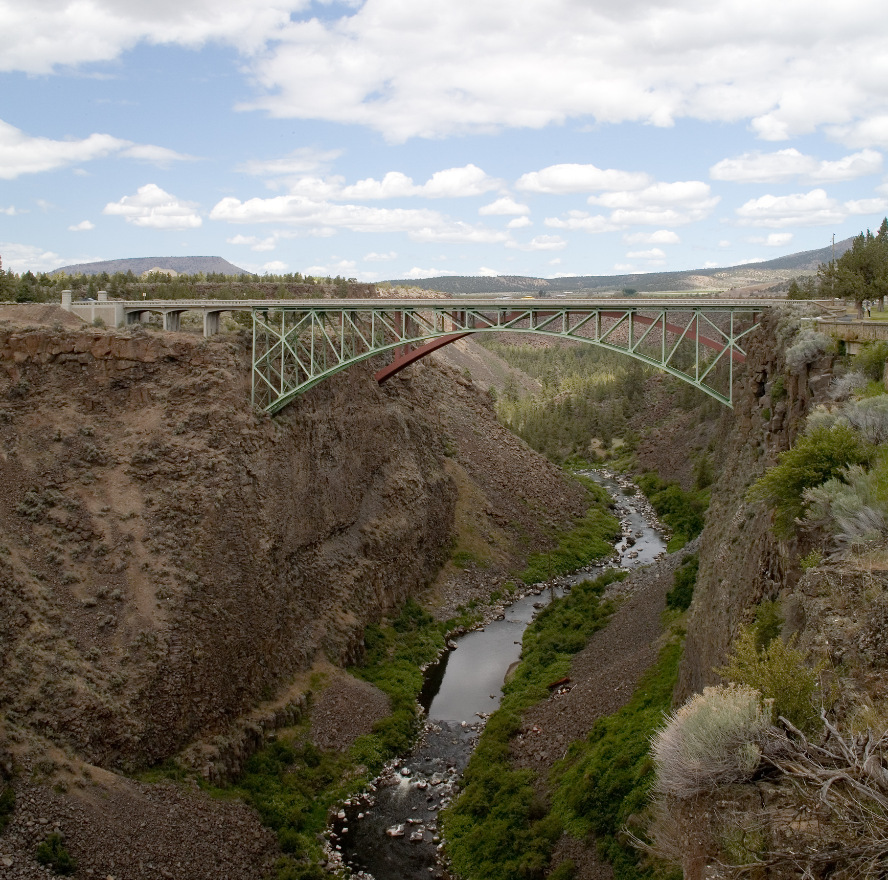
The Crooked River High Bridge is a steel arch bridge that spans the Crooked River gorge in Jefferson County, Oregon. The bridge was designed by Conde McCullough and was completed in 1926. Shortly after its completion, Oregon State Highway Division created the Peter Skene Ogden Park just to the south of the bridge.
The bridge has a total length of 464 feet with a main span of 330 feet. The deck is 295 ft above the canyon floor. The bridge was eventually unable to keep up with the growing traffic demands of U.S. Highway 97, and was replaced by the wider Rex T. Barber Veterans Memorial Bridge. The old bridge is open to pedestrians.
External links
Sources
- Elegant Arches, Soaring Spans: C.B. McCullough, Oregon's Master Bridge Builder, Robert W. Hadlow, Oregon State University Press, 2001. ISBN 0-87071-534-8.
Categories: - Deck arch bridges
- Bridges completed in 1926
- Road bridges in Oregon
- United States bridge (structure) stubs
- Oregon building and structure stubs
Wikimedia Foundation.
2010.
Look at other dictionaries:
Crooked River (Oregon) — Crooked River Daten Gewässerkennzahl … Deutsch Wikipedia
Crooked River State Park — is a 500 acre (2.02 km²) Georgia state park located near St. Mary s on the south bank of the Crooked River, providing an excellent coastal setting. In addition to a boat ramp, the park is near the ruins of the McIntosh Sugar Works , built around… … Wikipedia
Rex T. Barber Veterans Memorial Bridge — Infobox Bridge bridge name=Rex T. Barber Veterans Memorial Bridge carries=U.S. Highway 97 crosses=Crooked River locale=Jefferson County, Oregon design=concrete arch mainspan=ft to m|410|precision=2 length=ft to m|410|precision=2 open=2000… … Wikipedia
Crooked Creek Wildlife Management Area — is a protected area located in Carroll County, Virginia. Its 1,796 acres (7.27 km2) include forests and open land, and contain portions of Crooked Creek and its east fork. Most of the area was once farmland, and the sites of a number of old… … Wikipedia
Crooked Run (Monongahela River) — Crooked Run Creek is a tributary of the Monongahela River southeast of Pittsburgh, Pennsylvania. It runs for 3.2 miles (5.1 km),[1] from its origin in North Versailles Township (near the intersection of Crooked Run and Foster roads) until… … Wikipedia
River Camel — Infobox River river name = River Camel image size = 300px caption = The Camel valley in winter. Taken from between Pendavey bridge and Polbrock looking upstream origin = Bodmin Moor mouth = Padstow Bay basin countries = length mi = 30 elevation … Wikipedia
Cuyahoga River — watershed with its upstream branches Origin … Wikipedia
Little Cacapon River — For other places called Little Cacapon, see Little Cacapon (disambiguation). The Little Cacapon viewed north from the Okonoko Little Cacapon Road (County Route 2/7) bridge The Little Cacapon River is a 25.1 mile long (40.4 km)[1] free… … Wikipedia
Columbia River Gorge — For the Washington Oregon wine region, see Columbia Gorge AVA. Columbia River Gorge Protected Area L … Wikipedia
List of high schools in Alberta — This is a list of high schools in Alberta.A;Acadia Valley: Warren Peers School;Acme: Acme School;Airdrie: AE Bowers Middle School: RJ Hockey Middle School: Rocky View Virtual School: Airdrie Alternative School: Airdrie Altvirtual Program: Airdrie … Wikipedia