- Croft Spa railway station
-
Croft Spa 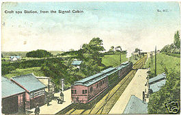
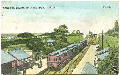
Croft Spa station from the signal cabin in 1908 Location Area Richmondshire Coordinates 54°28′59″N 1°33′00″W / 54.483°N 1.550°WCoordinates: 54°28′59″N 1°33′00″W / 54.483°N 1.550°W Grid reference NZ303060 Operations Original company Great North of England Railway Pre-grouping North Eastern Railway Post-grouping London and North Eastern Railway History 30 March 1841 Station opened as Croft 1 October 1896 Station renamed Croft Spa 3 March 1969 Station closed Disused railway stations in the United Kingdom Closed railway stations in Britain
A B C D–F G H–J K–L M–O P–R S T–V W–ZCroft Spa railway station was located on the East Coast Main Line between Northallerton and Darlington in North Yorkshire, England. The station served the settlements of Croft-on-Tees and Hurworth-on-Tees.
The station was served by local trains on the East Coast Main Line, and also trains operating the Eryholme-Richmond branch line.
Contents
History
Opened on 27 October 1829,[1] it became part of the London and North Eastern Railway during the Grouping of 1923. Passing on to the Eastern Region of British Railways on nationalisation in 1948 . In 1958 local trains between Northallerton and Darlington ceased stopping and it was then served only by trains to and from the Richmond branch until closure by the British Railways Board.
The station was demolished in the 1970s leaving no trace of its existence but trains still pass the site on the East Coast Main Line.
See also
References
- Butt, R. V. J. (1995). The Directory of Railway Stations: details every public and private passenger station, halt, platform and stopping place, past and present (1st ed.). Sparkford: Patrick Stephens Ltd. ISBN 1-8526-0508-1. OCLC 60251199.
- Jowett, Alan (2000). Jowett's Nationalised Railway Atlas (1st ed.). Penryn, Cornwall: Atlantic Transport Publishers. ISBN 0-9068-9999-0. OCLC 228266687.
- Jowett, Alan (March 1989). Jowett's Railway Atlas of Great Britain and Ireland: From Pre-Grouping to the Present Day (1st ed.). Sparkford: Patrick Stephens Ltd. ISBN 1-8526-0086-1. OCLC 22311137.
External links
- Croft Spa, SubBrit disused stations project
- Croft station on navigable 1947 O. S. map.
Preceding station Disused railways Following station Darlington Bank Top East Coast Main Line
Former local servicesEryholme
Station closedCategories:- Disused railway stations in North Yorkshire
- Railway stations opened in 1829
- Railway stations closed in 1969
- Yorkshire and the Humber railway station stubs
Wikimedia Foundation. 2010.