- Croagh Patrick Heritage Trail
-
Croagh Patrick Heritage Trail 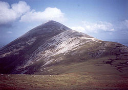
Croagh Patrick Length 61 kilometres (38 miles)[1] Location County Mayo, Ireland Designation National Waymarked Trail[1] Trailheads Balla, Murrisk[1] Use Hiking Elevation Gain/Loss 1,205 m (3,953 ft)[2] Highest point 310 m (1,017 ft)[2] Trail difficulty Moderate[1] Season Any Website http://www.croaghpatrickheritagetrail.com/ The Croagh Patrick Heritage Trail (Irish: Siúlóid Oidhreachta)[2] is a long-distance trail in County Mayo, Ireland. It is 61 kilometres (38 miles) long and begins in Balla and ends in Murrisk. It is typically completed in three days.[2] It is designated as a National Waymarked Trail by the National Trails Office of the Irish Sports Council and is managed by the Tóchar Valley Rural Community Network.[1] It was opened by Éamon Ó Cuív, T. D., Minister for Community, Rural and Gaeltacht Affairs on 6 March 2009.[3] The trail won the runners-up prize in the Heritage category of the 2009 Co-operation Ireland Pride of Place awards.[3]
The trail travels in a westerly direction from Balla on a mixture of quiet roads, boreens, fields and forest and mountain tracks past the villages of Clogher, Ballintubber, Killavally and Aghagower before crossing the northern flanks of Croagh Patrick to reach Murrisk.[4]
References
- ^ a b c d e "Croagh Patrick Heritage Trail". IrishTrails. Irish Sports Council. http://www.irishtrails.ie/trail/Croagh-Patrick-Heritage-Trail/10/. Retrieved 1 August 2011.
- ^ a b c d "Croagh Patrick Heritage Trail". Croagh Patrick Heritage Trail. Tóchar Valley Rural Community Network. http://www.croaghpatrickheritagetrail.com/. Retrieved 1 August 2011.
- ^ a b "Pride of Place Awards 2009". Croagh Patrick Heritage Trail. Tóchar Valley Rural Community Network. 23 November 2009. http://www.croaghpatrickheritagetrail.com/news/pride-of-place-awards/. Retrieved 1 August 2011.
- ^ "Trail Description". Croagh Patrick Heritage Trail. Tóchar Valley Rural Community Network. http://www.croaghpatrickheritagetrail.com/trail-description/. Retrieved 1 August 2011.
External links
Long-distance trails in the Republic of Ireland National Waymarked Trails Ballyhoura Way · Barrow Way · Bealach na Gaeltachta, Dún na nGall · Beara Way · Blackwater Way · Bluestack Way · Burren Way · Cavan Way · Croagh Patrick Heritage Trail · Dingle Way · Dublin Mountains Way · East Clare Way · East Munster Way · Grand Canal Way · Hymany Way · Kerry Way · Lough Derg Way · Mid Clare Way · Miners Way and Historical Trail · Monaghan Way · Multeen Way · Nore Valley Way · North Kerry Way · Offaly Way · Royal Canal Way · Sheep's Head Way · Slieve Bloom Way · Slieve Felim Way · Sligo Way · South Leinster Way · Suck Valley Way · Táin Way · Tipperary Heritage Way · Western Way · Westmeath Way · Wicklow Way
Pilgrim Paths Greenways Great Southern Trail · Great Western GreenwayOther Categories:- Long-distance trails in the Republic of Ireland
- Geography of County Mayo
- Visitor attractions in County Mayo


Wikimedia Foundation. 2010.