Killara County

Killara County
Killara
New South Wales
Killara NSW.PNG
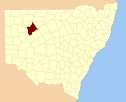
Location in New South Wales
Lands administrative divisions around Killara
Fitzgerald Fitzgerald Landsborough
Yungnulgra Killara Yanda
Young Werunda Rankin

Killara County is one of the 141 Cadastral divisions of New South Wales. The Darling River is its south eastern boundary.

Killara County was named after Killara Station with Killara believed to be derived from a local Aboriginal word.[1]

Parishes within this county

A full list of parishes found within this county; their current LGA and mapping coordinates to the approximate centre of each location is as follows:

Parish LGA Coordinates
Arabi Central Darling Shire 30°45′17″S 144°27′03″E / 30.75472°S 144.45083°E / -30.75472; 144.45083 (Arabi)
Balara Central Darling Shire 30°50′45″S 144°12′43″E / 30.84583°S 144.21194°E / -30.84583; 144.21194 (Balara)
Batthing Central Darling Shire 30°49′03″S 143°48′26″E / 30.8175°S 143.80722°E / -30.8175; 143.80722 (Batthing)
Binpooker Central Darling Shire 30°21′28″S 144°00′45″E / 30.35778°S 144.0125°E / -30.35778; 144.0125 (Binpooker)
Bonny Central Darling Shire 30°48′45″S 143°34′44″E / 30.8125°S 143.57889°E / -30.8125; 143.57889 (Bonny)
Bungadool Central Darling Shire 30°56′05″S 144°09′56″E / 30.93472°S 144.16556°E / -30.93472; 144.16556 (Bungadool)
Byco Birra Central Darling Shire 30°49′24″S 144°01′53″E / 30.82333°S 144.03139°E / -30.82333; 144.03139 (Byco Birra)
Callindra Central Darling Shire 31°12′37″S 143°48′20″E / 31.21028°S 143.80556°E / -31.21028; 143.80556 (Callindra)
Calpacaira Central Darling Shire 30°33′31″S 144°02′18″E / 30.55861°S 144.03833°E / -30.55861; 144.03833 (Calpacaira)
Cobrilla Central Darling Shire unknown
Devon Central Darling Shire 31°09′19″S 143°53′18″E / 31.15528°S 143.88833°E / -31.15528; 143.88833 (Devon)
Dilkoosha Central Darling Shire unknown
Dolora Central Darling Shire 31°20′07″S 143°59′32″E / 31.33528°S 143.99222°E / -31.33528; 143.99222 (Dolora)
Euola Central Darling Shire 31°00′09″S 144°02′32″E / 31.0025°S 144.04222°E / -31.0025; 144.04222 (Euola)
Far West Central Darling Shire 30°37′09″S 144°19′50″E / 30.61917°S 144.33056°E / -30.61917; 144.33056 (Far West)
Gigel Central Darling Shire 31°23′18″S 143°52′21″E / 31.38833°S 143.8725°E / -31.38833; 143.8725 (Gigel)
Gordon Central Darling Shire 31°04′12″S 143°47′59″E / 31.07°S 143.79972°E / -31.07; 143.79972 (Gordon)
Graham Central Darling Shire 31°01′12″S 143°40′20″E / 31.02°S 143.67222°E / -31.02; 143.67222 (Graham)
Hay Central Darling Shire 31°06′35″S 144°08′50″E / 31.10972°S 144.14722°E / -31.10972; 144.14722 (Hay)
Jamieson Central Darling Shire 31°15′20″S 143°57′33″E / 31.25556°S 143.95917°E / -31.25556; 143.95917 (Jamieson)
Kambula Central Darling Shire unknown
Killara Central Darling Shire 30°53′44″S 144°25′14″E / 30.89556°S 144.42056°E / -30.89556; 144.42056 (Killara)
Marra Central Darling Shire 30°59′31″S 144°20′00″E / 30.99194°S 144.3333333°E / -30.99194; 144.3333333 (Marra)
Moollawoolka Central Darling Shire 30°33′23″S 143°52′38″E / 30.55639°S 143.87722°E / -30.55639; 143.87722 (Moollawoolka)
Mount Jack Central Darling Shire 30°56′32″S 143°32′14″E / 30.94222°S 143.53722°E / -30.94222; 143.53722 (Mount Jack)
Muntawa Central Darling Shire 30°54′03″S 143°39′41″E / 30.90083°S 143.66139°E / -30.90083; 143.66139 (Muntawa)
Musgrave Central Darling Shire 30°43′24″S 143°58′03″E / 30.72333°S 143.9675°E / -30.72333; 143.9675 (Musgrave)
Myali Central Darling Shire 31°03′09″S 144°15′12″E / 31.0525°S 144.25333°E / -31.0525; 144.25333 (Myali)
Myall Central Darling Shire 30°37′42″S 144°08′57″E / 30.62833°S 144.14917°E / -30.62833; 144.14917 (Myall)
Newland Central Darling Shire 31°07′39″S 143°59′41″E / 31.1275°S 143.99472°E / -31.1275; 143.99472 (Newland)
Parkes Central Darling Shire 31°04′09″S 143°56′32″E / 31.06917°S 143.94222°E / -31.06917; 143.94222 (Parkes)
Paroo Central Darling Shire 30°36′25″S 144°00′50″E / 30.60694°S 144.01389°E / -30.60694; 144.01389 (Paroo)
Pulacarra Central Darling Shire 30°43′49″S 144°04′16″E / 30.73028°S 144.07111°E / -30.73028; 144.07111 (Pulacarra)
Reddin Central Darling Shire 31°05′33″S 143°37′26″E / 31.0925°S 143.62389°E / -31.0925; 143.62389 (Reddin)
Service Central Darling Shire 30°43′13″S 144°15′23″E / 30.72028°S 144.25639°E / -30.72028; 144.25639 (Service)
Stewart Central Darling Shire 30°59′25″S 144°12′20″E / 30.99028°S 144.20556°E / -30.99028; 144.20556 (Stewart)
Tallandra Central Darling Shire 31°24′11″S 143°40′25″E / 31.40306°S 143.67361°E / -31.40306; 143.67361 (Tallandra)
Tallarara Central Darling Shire 30°53′06″S 143°50′37″E / 30.885°S 143.84361°E / -30.885; 143.84361 (Tallarara)
Thoolabool Central Darling Shire 30°48′15″S 144°19′38″E / 30.80417°S 144.32722°E / -30.80417; 144.32722 (Thoolabool)
Tilpa Central Darling Shire 30°52′35″S 144°33′49″E / 30.87639°S 144.56361°E / -30.87639; 144.56361 (Tilpa)
Towri Central Darling Shire 31°03′38″S 144°05′36″E / 31.06056°S 144.09333°E / -31.06056; 144.09333 (Towri)
Tutty Central Darling Shire 30°30′04″S 144°12′56″E / 30.50111°S 144.21556°E / -30.50111; 144.21556 (Tutty)
Undelcarra Central Darling Shire 30°46′08″S 144°10′15″E / 30.76889°S 144.17083°E / -30.76889; 144.17083 (Undelcarra)
Walker Central Darling Shire 31°10′51″S 144°02′25″E / 31.18083°S 144.04028°E / -31.18083; 144.04028 (Walker)
Warook Central Darling Shire 30°58′30″S 143°48′22″E / 30.975°S 143.80611°E / -30.975; 143.80611 (Warook)
Warramutty Central Darling Shire 30°27′12″S 143°57′00″E / 30.45333°S 143.95°E / -30.45333; 143.95 (Warramutty)
Wolseley Central Darling Shire 30°55′27″S 144°17′45″E / 30.92417°S 144.29583°E / -30.92417; 144.29583 (Wolseley)
Yamaranie Central Darling Shire 30°26′44″S 144°06′08″E / 30.44556°S 144.10222°E / -30.44556; 144.10222 (Yamaranie)

References

  1. ^ Geographical Names Board of NSW

Wikimedia Foundation. 2010.

Игры ⚽ Нужно сделать НИР?

Look at other dictionaries:

  • Killara County, New South Wales — Infobox Australian cadastral name = Killara state = New South Wales caption = Location in New South Wales near nw = Fitzgerald near n = Fitzgerald near ne = Landsborough near e = Yanda near se = Rankin near s = Werunda near sw = Young near w =… …   Wikipedia

  • County of Normanby — Normanby Victoria Location in Victoria Lands administrative divisions around Normanby …   Wikipedia

  • Fitzgerald County, New South Wales — Infobox Australian cadastral name = Fitzgerald state = New South Wales caption = Location in New South Wales near nw = Yantara near n = Ularara near ne = Barrona near e = Landsborough near se = Killara near s = Killara near sw = Yungnulgra near w …   Wikipedia

  • Rankin County, New South Wales — Infobox Australian cadastral name = Rankin state = New South Wales caption = Location in New South Wales near nw = Killara near n = Landsborough near ne = Yanda near e = Robinson near se = Booroondarra near s = Woore near sw = Werunda near w =… …   Wikipedia

  • Fitzgerald County — Map of all coordinates from Google Map of all coordinates from Bing Export all coordinates as KML …   Wikipedia

  • Yungnulgra County, New South Wales — Infobox Australian cadastral name = Yungnulgra state = New South Wales caption = Location in New South Wales near nw = Yantara near n = Yantara near ne = Fitzgerald near e = Killara near se = Killara near s = Young near sw = Mootwingee near w =… …   Wikipedia

  • Yungnulgra County — Map of all coordinates from Google Map of all coordinates from Bing Export all coordinates as KML …   Wikipedia
  • Landsborough County, New South Wales — Infobox Australian cadastral name = Landsborough state = New South Wales caption = Location in New South Wales near nw = Ularara near n = Barrona near ne = Gunderbooka near e = Gunderbooka near se = Yanda near s = Rankin near sw = Killara near w …   Wikipedia

  • Young County, New South Wales — Infobox Australian cadastral name = Young state = New South Wales caption = Location in New South Wales near nw = Mootwingee near n = Yungnulgra near ne = Killara near e = Werunda near se = Livingstone near s = Livingstone near sw = Tandora near… …   Wikipedia

  • Landsborough County — Map of all coordinates from Google Map of all coordinates from Bing Export all coordinates as KML …   Wikipedia

Share the article and excerpts

Direct link
Do a right-click on the link above
and select “Copy Link”