- Dudley County
-
Dudley
New South Wales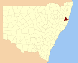
Location in New South WalesLands administrative divisions around Dudley Clarke Raleigh Pacific Ocean Vernon Dudley Pacific Ocean Hawes Macquarie Pacific Ocean Dudley County is one of the 141 Cadastral divisions of New South Wales. Part of the southern border near the coast is the Apsley River.
Dudley County was named in honour of Dudley Ryder, Second Earl of Harrowby (1798-1882).[1]
Parishes within this county
A full list of parishes found within this county; their current LGA and mapping coordinates to the approximate centre of each location is as follows:
References
Categories:- Counties of New South Wales
Wikimedia Foundation. 2010.