- Elmira/Corning Regional Airport
-
Elmira/Corning Regional Airport 
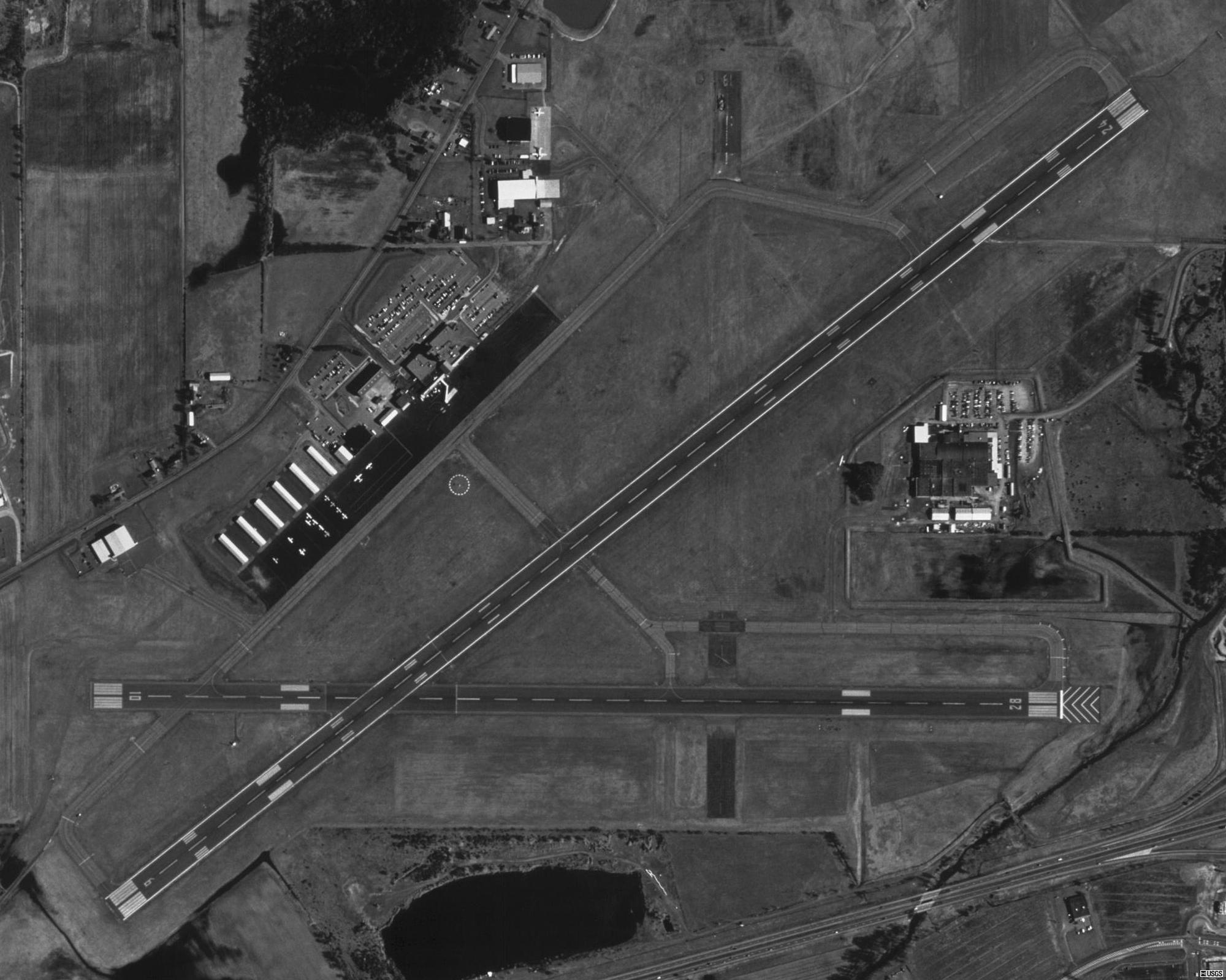
USGS aerial image - 22 April 1994 IATA: ELM – ICAO: KELM – FAA LID: ELM Summary Airport type Public Owner County of Chemung Serves Elmira / Corning, New York Location Big Flats / Horseheads Elevation AMSL 954 ft / 291 m Coordinates 42°09′36″N 076°53′30″W / 42.16°N 76.89167°W Website Runways Direction Length Surface ft m 6/24 7,599 2,316 Asphalt 10/28 5,404 1,647 Asphalt 5/23 2,017 615 Turf Statistics (2007) Aircraft operations 41,865 Based aircraft 57 Source: Federal Aviation Administration[1]  FAA diagram of Elmira/Corning Regional Airport (ELM)
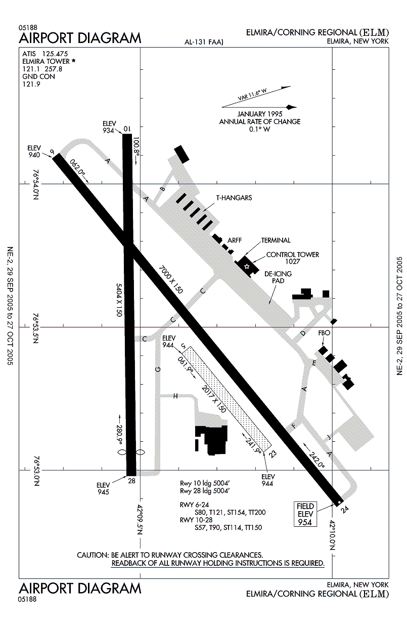
Elmira/Corning Regional Airport[1][2] (IATA: ELM, ICAO: KELM, FAA LID: ELM) is a county-owned, public-use airport in Chemung County, New York, United States.[1] The airport is six nautical miles (11 km) northwest of the central business district of the city of Elmira[1] and seven nautical miles (13 km) east of the city of Corning.[3] It is located in the town of Big Flats,[4] but its mailing address is in the adjacent town of Horseheads, New York.[4][5] The airport was formerly known as Elmira Regional Airport.[6]
The airport serves the Southern Tier of New York, primarily Chemung and Steuben counties. It has scheduled air service along with general aviation and glider activities. It is north of the Southern Tier Expressway (New York State Route 17). Other similar airports within the same service area include Greater Binghamton Airport and Ithaca Tompkins Regional Airport. Greater Rochester International Airport and Syracuse International Airport are the closest two airports with low cost carrier service.
Contents
Facilities and aircraft
Elmira/Corning Regional Airport covers an area of 1,000 acres (400 ha) at an elevation of 954 feet (291 m) above mean sea level. It has three runways: 6/24 is 7,599 by 150 feet (2,316 x 46 m) with an asphalt surface; 10/28 is 5,404 by 150 feet (1,647 x 46 m) with an asphalt surface; 5/23 is 2,017 by 150 feet (615 x 46 m) with a turf.[1]
For the 12-month period ending December 31, 2007, the airport had 41,865 aircraft operations, an average of 114 per day: 75% general aviation, 25% air taxi, <1% scheduled commercial and <1% military. At that time there were 57 aircraft based at this airport: 63% single-engine, 11% multi-engine, 14% jet, 9% glider and 4% helicopter.[1]
An aviation museum known as Wings of Eagles is located at the airport.[7] Airport services include free wireless Internet access, automatic teller machines (ATM), conference rooms, and the DC2 Restaurant. The Helicopter manufacturer Schweizer Aircraft is also located at the airport.
Airlines and destinations
Airlines Destinations Allegiant Air Fort Lauderdale, Orlando-Sanford Delta Connection operated by Atlantic Southeast Airlines Detroit Delta Connection operated by Pinnacle Airlines Detroit US Airways Express operated by Air Wisconsin Philadelphia US Airways Express operated by Piedmont Airlines Philadelphia Top Destinations
Busiest domestic routes out of ELM
(July 2010 - June 2011) [8]Rank City Passengers Carriers 1  Detroit, MI
68,000 Delta 2  Philadelphia, PA
53,000 US Airways 3  Orlando-Sanford, FL
16,000 Allegiant 4 Fort Lauderdale, FL7,000 Allegiant Incidents
On June 23, 1967, Mohawk Airlines Flight 40, operated on a BAC-111 regional jet, crashed in Blossburg, Pennsylvania, shortly after taking off from Elmira-Corning, killing all 34 persons (30 passengers and 4 crew) on board.[9]
References
- ^ a b c d e f FAA Airport Master Record for ELM (Form 5010 PDF). Federal Aviation Administration. Effective 27 August 2009.
- ^ Elmira/Corning Regional AirportPDF. New York State Department of Transportation. Accessed 13 October 2009.
- ^ Heading and distance from Corning (42°08'53"N 77°03'25"W) to ELM. Great Circle Mapper. Accessed 13 October 2009.
- ^ a b Elmira-Corning Regional Airport. Town of Big Flats. Accessed 13 October 2009.
- ^ Elmira Corning Regional Airport: Contacts. Accessed 13 October 2009.
- ^ Elmira Regional Airport. Aviation Safety Network. Accessed 13 October 2009.
- ^ Wings of Eagles website. Accessed 13 October 2009.
- ^ http://www.transtats.bts.gov/airports.asp?pn=1&Airport=ELM&Airport_Name=Elmira/Corning,%20NY:%20Harris%20Hill%20Glider%20Port&carrier=FACTS
- ^ Accident description at the Aviation Safety Network. Accessed 13 October 2009.
External links
- Elmira Corning Regional Airport, official site
- FAA Airport Diagram (PDF), effective 20 October 2011
- FAA Terminal Procedures for ELM, effective 20 October 2011
- Resources for this airport:
- AirNav airport information for KELM
- ASN accident history for ELM
- FlightAware airport information and live flight tracker
- NOAA/NWS latest weather observations
- SkyVector aeronautical chart for KELM
- FAA current ELM delay information
Categories:- Airports in New York
- Buildings and structures in Chemung County, New York
- Transportation in Chemung County, New York
Wikimedia Foundation. 2010.