- Community Boating, Inc
-
Community Boating Inc. Type Not-for-profit corporation Industry Sailing Founded 1936 Headquarters Boston, Massachusetts Key people Joseph Lee Jr, Founder
Holger Kunst, President of the BoardWebsite http://www.community-boating.org 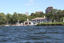 Community Boating Inc. as seen from a Duck boat on the Charles River.
Community Boating, Inc. (CBI) is a private not-for-profit corporation run in association with the Massachusetts Department of Conservation and Recreation. Organized as a company in 1946,[1] it is the oldest continuously operating community sailing program in the United States.[citation needed] It is located in Boston along the Charles River Esplanade between the Longfellow Bridge and the Hatch Shell. CBI offers members instruction for sailing and windsurfing, and allows members to use CBI-owned sailboats on the Charles River.
CBI's primary boat is the Cape Cod Mercury, of which they have 78. All new members are introduced to sailing on this boat and must display proficiency in sailing with a jib in high winds before being allowed to sail high-performance boats. Two Mercuries are specially designed for persons with disabilities. Their high-performance fleet includes six Rhodes 19s, four Sonars, 13 Lasers, and 19 420s. The Rhodes 19 is used for excursions into Boston Harbor and the islands. The 420 is the boat of choice for high school racing teams, which practice and race through CBI. CBI is most well-known for being affordable and accessible to everyone. The universal access program, which allows disabled people the opportunity to sail Sonars or specially rigged Mercuries, costs only $1. The junior program, which is a summer camp for young people ages 10–18, costs $1 for the entire summer. The regular rates are intended to be accessible to a broad range of people; a yearlong adult membership cost $259 (see application form).[2]
References
- ^ http://www.community-boating.org/about-us/history
- ^ http://www.community-boating.org/join/how-to-join#h0-1-how-to-join-for-adults
External links
Coordinates: 42°21′35″N 71°04′23″W / 42.359836°N 71.073051°W
Categories:- Boating associations
- Non-profit organizations based in Massachusetts
- United States organization stubs

Wikimedia Foundation. 2010.