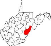
- Hosterman, West Virginia
-
Hosterman, West Virginia — Unincorporated community — Coordinates: 38°28′23″N 79°51′23″W / 38.47306°N 79.85639°WCoordinates: 38°28′23″N 79°51′23″W / 38.47306°N 79.85639°W Country United States State West Virginia County Pocahontas Elevation 2,612 ft (796 m) Time zone Eastern (EST) (UTC-5) – Summer (DST) EDT (UTC-4) Area code(s) 304 & 681 GNIS feature ID 1554747[1] Hosterman is an unincorporated community in Pocahontas County, West Virginia, United States. Hosterman is located on the Greenbrier River 5.5 miles (8.9 km) south-southwest of Durbin. The community was originally named Collins; its name was changed to Hosterman in 1902.[1]
References
Municipalities and communities of Pocahontas County, West Virginia Towns CDPs Bartow | Cass | Frank | Green Bank | Huntersville
Unincorporated
communitiesArbovale | Beard | Beard Heights | Boyer | Braucher | Brownsburg | Buckeye | Burner | Burnsides | Burr | Campbelltown | Clawson | Clover Lick | Deer Creek | Denmar | Dilleys Mill | Droop | Dunmore | Edray | Frost | Harter | Hosterman | Jacox | Kennison | Knapp | Linwood | Lobelia | Locust | Mace | May | Mill Point | Minnehaha Springs | Nida | Nottingham | Olive | Onoto | Raintown | Raywood | Rimel | Seebert | Sitlington | Slaty Fork | Snowshoe | Spice | Spruce | Stillwell | Stony Bottom | Thornwood | Thorny Creek | Violet | Walnut | Wanless | Warwick | Watoga | West Union | Wildell | Woodrow
Ghost towns Gertrude | Mill Run | Sunset
Categories:- Populated places in Pocahontas County, West Virginia
- Unincorporated communities in West Virginia
- Pocahontas County, West Virginia geography stubs
Wikimedia Foundation. 2010.


