- Madawaska County, New Brunswick
-
Madawaska — County — Location of Madawaska County, New Brunswick
Country  Canada
Province  New Brunswick
Established 1873 Area[1] – Land 3,461.46 km2 (1,336.5 sq mi) Population (2006)[1][2] – Total 34,071 – Density 9.8/km2 (25.4/sq mi) – Change 2001-06  4.3%
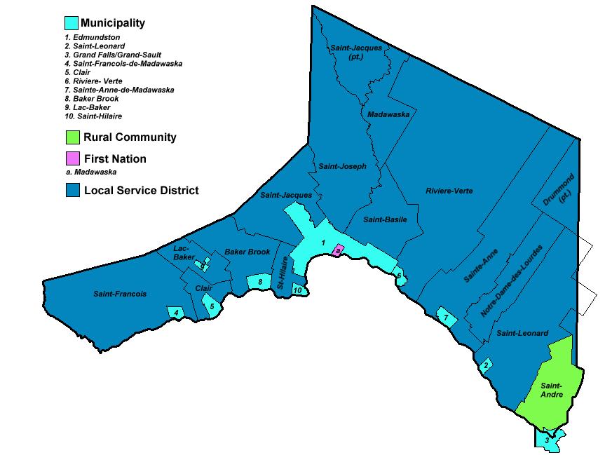
4.3%Time zone AST (UTC-4) – Summer (DST) ADT (UTC-3) Area code(s) 506 Dwellings 15,888 Median Income* $42,709 *Median household income, 2005 (all households)  Map of municipal government units in Madawaska County.
Madawaska County (2006 population 34,071), also known as the "New Brunswick Panhandle", is located in northwestern New Brunswick, Canada. Over 90% of the county's population speaks French. Its Francophone population are known as "Brayons." Forestry is the major industry in the county.
Contents
History
The first inhabitants of what is now called Madawaska county, were the Maliseet or Wolastoqiyik, who occupied and used the land along the St. John River Valley north to the St. Lawrence River and south to the Penobscot River. There is debate concerning the true origin of the word "Madawaska". The earliest European settlers were from Quebec. The area was the focus of the bloodless Aroostook War, a border dispute led by businessman and political activist John Baker.
The earliest settlers of the Upper St-John River Valley can be clearly verified with http://www.upperstjohn.com/visits/Saint-Vallier1686.htm and http://www.upperstjohn.com/1820/madawaska.htm the second link displays census results taken in 1820 of the Madawaska region where most families had originated from Quebec.
Census subdivisions
Communities
There are ten incorporated municipalities within Madawaska County (listed by 2006 population counts and national census rankings):[1][2]
Official Name Status Area km2 Population Census Ranking Edmundston City 106.92 16,643 232 of 5,008 Saint-Léonard Town 5.20 1,352 1,705 of 5,008 Sainte-Anne-de-Madawaska Village 9.21 1,073 1,957 of 5,008 Clair Village 10.46 848 2,280 of 5,008 Rivière-Verte Village 7.00 798 2,366 of 5,008 Saint-François-de-Madawaska Village 6.34 585 2,806 of 5,008 Baker Brook Village 12.40 525 2,944 of 5,008 Saint-André Village 3.72 404 3,303 of 5,008 Saint-Hilaire Village 5.67 231 3,908 of 5,008 Lac-Baker Village 4.02 169 4,146 of 5,008 Parishes
The county is subdivided into fourteen parishes (listed by 2006 population counts and national census rankings):[1][2]
Official Name Status Area km2 Population Census Ranking Saint-Joseph Parish 321.87 1,696 1,472 of 5,008 Saint-André Parish 132.48 1,660 1,492 of 5,008 Saint-Jacques Parish 298.82 1,607 1,531 of 5,008 Sainte-Anne Parish 369.25 1,081 1,942 of 5,008 Saint-Léonard Parish 343.95 1,039 2,011 of 5,008 Saint-Basile Parish 129.73 799 2,364 of 5,008 Rivière-Verte Parish 715.58 791 2,384 of 5,008 Saint-François Parish 344.70 754 2,458 of 5,008 Lac-Baker Parish 57.38 566 2,847 of 5,008 Saint-Hilaire Parish 41.55 531 2,928 of 5,008 Notre-Dame-de-Lourdes Parish 188.63 284 3,729 of 5,008 Clair Parish 44.29 282 3,737 of 5,008 Baker Brook Parish 125.69 177 4,103 of 5,008 Madawaska Parish 173.32 10 4,889 of 5,008 First Nations
There is one First Nations reservation in Madawaska County (listed by 2006 population counts and national census rankings):[1][2]
Official Name Status Area km2 Population Census Ranking St. Basile 10 Reservation 3.28 166 4,161 of 5,008 Demographics
Population trend[3]
Census Population Change (%) 2006 34,071 4.3%2001 35,611 3.3%1996 36,814  0.7%
0.7%1991 36,554 N/A Mother tongue language (2006)[1]
Language Population Pct (%) French only 31,185 93.06% English only 1,665 4.97% Other languages 395 1.18% Both English and French 265 0.79% See also
References
External links
- Madawaska County Guide
- http://www.transmission.bpa.gov/cigresc14/Compendium/MADAWAS.htm
- http://www.transmission.bpa.gov/cigresc14/Compendium/Madawas%20Pictures.pdf

Témiscouata Regional County Municipality  Quebec
Restigouche County 
 Madawaska County

Aroostook County, Maine
 United States
Victoria County Subdivisions of New Brunswick Subdivisions Cities Counties Albert · Carleton · Charlotte · Gloucester · Kent · Kings · Madawaska · Northumberland · Queens · Restigouche · Saint John · Sunbury · Victoria · Westmorland · YorkCoordinates: 47°25′17.1″N 68°21′38.2″W / 47.421417°N 68.360611°W

Wikimedia Foundation. 2010.