- Obalno-kraška statistical region
-
Coastal-Karst statistical region
Obalno-kraška statistična regija— Statistical region — 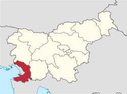
Largest city Koper Area – Total 1,044 km2 (403.1 sq mi) Population (2006) – Total 106,000 – Density 101.5/km2 (263/sq mi) Statistics – Households 44350 – Workers 42,591 – Unemployed 3719 – College/university students 5678 – Regional GDP: 1,353 m EUR
(12882 EUR per capita)The Coastal-Karst statistical region (Slovene: Obalno-kraška statistična regija) is a statistical region in the south-west of Slovenia. The region compromises 7 municipalities: Divača, Hrpelje-Kozina, Izola, Komen, Koper, Piran and Sežana.
It has an area of 1,044 km² and an estimated 106,000 inhabitants (at 1 January 2006) - of whom almost half live in the coastal city of Koper - and the second highest GDP per capita of the Slovenian regions. The percentage of foreigners is the highest in it of all regions at 4.2%.
Contents
Demographics
Population: 106,000
Economy
This region has the highest percentage of people employed in tertiary (services) activities. Employment structure: 70.6% services, 26.8% industry, 2.6% agriculture.
15% of the GDP is generated by transport.
Tourism
It has the most tourists of all the regions (24.5%), the tourist being from: 41.9% Slovenia, 17% Austria, 2.2% Croatia, 34.3% Italy, 14.7% Germany, 2.8% UK, 29% other countries.
Transportation
Length of motorways: 55 km Length of other roads: 822 km Also railways. It has the largest and only commercial port situated in Koper along with marinas in Koper, Izola and Portorož. There is also a smaller international airport.
Sources
Statistical regions of Slovenia  Gorenjska • Goriška • Jugovzhodna Slovenija • Koroška • Notranjsko-kraška • Obalno-kraška • Osrednjeslovenska • Podravska • Pomurska • Savinjska • Spodnjeposavska • Zasavska
Categories:- Statistical regions of Slovenia

Wikimedia Foundation. 2010.