- Misrah Ghar il-Kbir
-
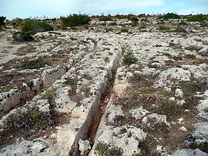 Cart Ruts at Misrah Ghar il-Kbir
Misrah Ghar il-Kbir (informally known as Clapham Junction) is a prehistoric site in Malta near the Dingli Cliffs. It is best known for its "cart ruts" - a complex network of tracks gouged in the rock. The age and purpose of the tracks are still a mystery of Maltese history. In general, most archeologists presume that the site developed about 2000 BC after new settlers came over from Sicily to start the Bronze Age in Malta.
It is reported that the "Clapham Junction" nickname was given by an Englishman, who later reported that it reminded him of the busy railway station Clapham Junction in London.
Origin of the tracks
The tracks (known and signposted in Malta as Cart Ruts) can be found in a number of sites on Malta and on Gozo. Busewdien in St Paul's Bay, Naxxar, San Gwann and Bidnija are good examples of cart tracks found on the Island of Malta. Gozo's best Cart Ruts are on the Ta’ Ċenċ plateau, Sannat. The Misraћ Gћar il-Kbir site near the Dingli Cliffs in the south of the island is probably the most impressive – they form here a real "traffic jam".
Also called cart ruts, they are up to 60 cm deep and have an average distance between them of 110 to 140 cm. Some cross while others form junctions. This creates the illusion of a great railway station switching yard.
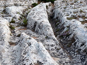 A cart ruts junction at Ghar il-Kbir
There are numerous theories about how these tracks were created. The most discussed are the following:
- Goods were transported here on sledges which gouged the tracks into the rock.
- The tracks are real cart ruts for transporting goods.
- It is an irrigation system.
There are also other attempts to explain the tracks:-
- The Maltese archeologist Anthony Bonanno thinks that the ruts are devices of the Phoenicians, which would mean that the tracks were made more recently, in the 7th century BC.
Recent research suggests that these may have been caused by wooden-wheeled carts eroding soft limestone. An analysis was made of the stresses that would have been caused by a cart which would fit the ruts. Professor Mottershead of Portsmouth University said " “The underlying rock in Malta is weak and when it’s wet it loses about 80 per cent of its strength. The carts would have first made tracks in the soil but when that eroded, the cartwheels ran directly on the bedrock, making it easier for other carts to follow the same tracks.”[1][2]
References
- ^ "Ancient mystery solved by geographers"[1]
- ^ Mottershead, Derek; Alastair Pearson & Martin Schaefer "The cart ruts of Malta: an applied geomorphology approach" Antiquity Vol 82:318, 2008 pp 1065-1079 [2] (pdf)
External links
 Media related to Misrah Ghar il-Kbir at Wikimedia Commons
- http://www.gozo.gov.mt/pages.aspx?page=747
Categories:- Archaeological sites in Malta
- History of Malta


Wikimedia Foundation. 2010.