- Mwinilunga
-

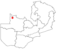
Mwinilunga is a town in the North-Western Province of Zambia and headquarters of a district of that name. It lies on the West Lunga River, not far from the borders with the Democratic Republic of the Congo and Angola.
Contents
Overview
The town had a population estimated at 14,500 in 2006. The Chilunda-speaking Kanongesha-Lunda people are the largest ethnic group, and are related to the Chibemba-speaking Kazembe-Lunda of Luapula Province.
The town's elevation is 1387 m and it is one of the wettest places in Zambia with annual rainfall of about 1400 mm falling in the rainy season from October to May. The town is also home to a small airport.
Schools
Mwinilunga Secondary School, is the largest school to date in town, 1985-1987 Tresford Kampinda Tungati was one of the studends to study at this school, followed by kingston Mwamba Tungati 1994 era, Festus Nkandu Tungati 1999 era and lastely Jeff Mulenga 2001 era. Government and Community Schools pepper the rural area surrounding the BOMA (British Overseas Management Area) and provide education for children grades 1 to 12.
Industry
Attempts have been made to establish industries in the town such as the TIKA Iron and Steel plant and the pineapple cannery. Neither were commercially successful and have closed due to the distance of the town from the markets of the Copperbelt and the lack of a railway and source of coking coal for the TIKA plant.[1]
In 2006 plans were formulated to extend the proposed railway to Solwezi to the town and even on to the Benguela Railway in Angola to avoid reliance on the line in the DR Congo, but these plans have not been confirmed and the Benguela Railway has not been re-opened.
Mwinilungu ought to benefit from trade with Angola and DR Congo (which both have considerable Lunda populations too) but wars, poor road conditions and various trade policies between the countries have so far prevented trade developing.
Forest Fruits Ltd. has been operating in Mwinilunga since 1997, successfully working with over 5000 beekeepers in the region to export organic honey to the European market.
There is much work investigating the possibility of nearby copper and uranium deposits. Such mines already exist in various location along the highway between Solwezi and Mwinilunga.
Tourism
The annual Chisemwa cha Lunda ceremony held by Senior Chief Kanongesha of the Lunda draws crowds to the district every September.[2]
Mwinilunga lies south east of the rainforest Nchila Wildlife Reserve, known for its sable antelope and other large mammals, Luakela Forest Reserve and the Chitunta Plain, known for its birdlife and as the source of the Zambezi River.
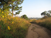 Pathway Between the Old and New Market
References
- ^ Times of Zambia website: Julius Kaoma: "Why steel, iron are key to national development", accessed 1 March 2007.
- ^ Times of Zambia website accessed 1 March 2007
Coordinates: 11°45′30″S 24°25′45″E / 11.75833°S 24.42917°E
Categories:- Populated places in Zambia
- Zambia geography stubs

Wikimedia Foundation. 2010.