- Church of St Mary, Chedzoy
-
Church of St Mary 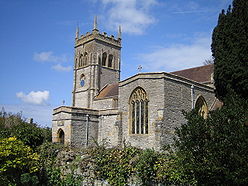
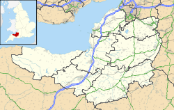
 Location within Somerset
General information Town or city Chedzoy Country England Coordinates 51°08′04″N 2°56′34″W / 51.1345°N 2.9429°W Completed 13th century The Anglican Church of St Mary in Chedzoy, Somerset, England dates from the 13th century and has been designated as a grade I listed building.[1]
There is evidence of a Church in Chedzoy in 1166 when it was given along with the parent church in North Petherton to Buckland Priory.[2] The tower dates from the early 16th century when the porch, clerestory, the arch into the north transept, and the windows in the north aisle were added.[3]
Much of the current building is from the 17th century, although the Norman chancel, chancel arch and doorway remain. It was extensively remodelled by William Butterfield in 1861.[4] A late medieval screen and rood loft were removed around 1841. The font has survived since the 13th century. The pulpit is form the 16th century. Amongst the memorials is a brass believed to commemorate Richard Sydenham who died in 1499.[2]
Local tradition says that the church still bears marks form the forces of The Duke of Monmouth during the Monmouth Rebellion who sharpened their swords before battle,[5] however this is unlikely to be the true source of the marks.[6]
The parish is part of the benefice of Westonzoyland with Chedzoy within the Sedgemoor deanery.[3]
See also
- List of Grade I listed buildings in Sedgemoor
- List of towers in Somerset
References
- ^ "Church of St Mary". Images of England. http://www.imagesofengland.org.uk/details/default.aspx?id=269531. Retrieved 6 December 2007.
- ^ a b "Chedzoy: Church". A History of the County of Somerset: Volume 6: Andersfield, Cannington, and North Petherton Hundreds (Bridgwater and neighbouring parishes). British History Online. http://www.british-history.ac.uk/report.aspx?compid=18656. Retrieved 18 September 2011.
- ^ a b "The Blessed Virgin Mary, Chedzoy". Church of England. http://acny.co.uk/11212/. Retrieved 18 September 2011.
- ^ "St Mary's, Chedzoy, Somerset". Minerva Stone Conservation. http://www.minervaconservation.com/projects/stmarys.html. Retrieved 18 May 2009.
- ^ Leete-Hodge, Lornie (1985). Curiosities of Somerset. Bodmin: Bossiney Books. p. 81. ISBN 0906456983.
- ^ "A Battlefield Drive". Battlefields Resource Centre. http://www.battlefieldstrust.com/resource-centre/stuart-rebellions/battlepageview.asp?pageid=140&parentid=139. Retrieved 18 September 2011.
External links
Categories:- Church of England churches in Somerset
- 13th-century architecture
- Grade I listed churches
- Grade I listed buildings in Somerset
- Sedgemoor


Wikimedia Foundation. 2010.