Church of St Lawrence, Stanton Prior

Church of St Lawrence, Stanton Prior
Church of St Lawrence
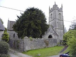
Location: Stanton Prior, Somerset, England
Coordinates: 51°21′46″N 2°27′50″W / 51.36278°N 2.46389°W / 51.36278; -2.46389Coordinates: 51°21′46″N 2°27′50″W / 51.36278°N 2.46389°W / 51.36278; -2.46389
Built: 12th century
Governing body: Church of St. Lawrence
Listed Building – Grade II*
Designated: 1 February 1954[1]
Reference #: 32713
Church of St Lawrence, Stanton Prior is located in Somerset
{{{alt}}}
Location of Church of St Lawrence in Somerset

The Anglican Church of St Lawrence in Stanton Prior, Somerset, England has its origins in the 12th century but is mainly 15th century. The church has been designated by English Heritage as a Grade II* listed building.[1]

The church has a 3-stage tower, supported by diagonal buttresses with polygonal stair turret on the north east corner.[1]

In 1860 a major restoration was undertaken and it was found that the nave and chancel were the same height, which had been obscured since the insertion of windows, raising of the walls and erection of the open timber roof during the Perpendicular Period.[2]

It is within the benefice of Farmborough, Marksbury and Stanton Prior and the Archdeaconry of Bath.[3]

References

  1. ^ a b c "Church of St Lawrence". Images of England. English Heritage. http://www.imagesofengland.org.uk/details/default.aspx?id=32713. Retrieved 24 December 2010. 
  2. ^ Robinson, W.J. (1915). West Country Churches. Bristol: Bristol Times and Mirror Ltd. pp. 169–173. 
  3. ^ "St Lawrence, Stanton Prior". Church of England. http://www.achurchnearyou.com/stanton-prior-st-lawrence/. Retrieved 24 December 2010. 

Wikimedia Foundation. 2010.

Игры ⚽ Нужен реферат?

Look at other dictionaries:

  • Stanton Prior — infobox UK place country = England latitude= 51.3644 longitude= 2.4633 scale= 10000 official name= Stanton Prior population= c. 80 shire district= Bath North East Somerset shire county = Somerset region= South West England constituency… …   Wikipedia

  • Church of St Peter, Marksbury — Church of St Peter Location: Marksbury, Somerset, England Coordinates …   Wikipedia

  • Elizabeth Cady Stanton — Infobox Person name = Elizabeth Cady Stanton image size = 289px caption = Elizabeth Cady Stanton and her daughter Harriot. birth date = birth date|mf=yes|1815|11|12|mf=y birth place = Johnstown, New York death date = death date and… …   Wikipedia

  • List of abbeys and priories in England — Contents 1 Overview 1.1 Article layout 2 Abbreviations and key …   Wikipedia

  • Marksbury — Coordinates: 51°21′31″N 2°28′44″W / 51.3587°N 2.4790°W / 51.3587; 2.4790 …   Wikipedia

  • List of Grade I listed buildings in Somerset — There are over 6000 Grade I listed buildings in England. This page is a list of these buildings in the county of Somerset.Bath North East Somerset* Abbey Church, Bath (Grade A) * Abbey Church Yard, Bath: No 14 * Grand Pump Room, Bath * Grand Pump …   Wikipedia

  • List of Grade I listed buildings in Derbyshire — There are over 6000 Grade I listed buildings in England. This page is a list of these buildings in the county of Derbyshire, sub divided by district.Amber Valley* North Mill, Belper * Church of St Mary, Crich * Church of St Mary, Denby * Church… …   Wikipedia

  • East Harptree — Coordinates: 51°18′02″N 2°37′18″W / 51.3005°N 2.6218°W / 51.3005; 2.6218 …   Wikipedia

  • performing arts — arts or skills that require public performance, as acting, singing, or dancing. [1945 50] * * * ▪ 2009 Introduction Music Classical.       The last vestiges of the Cold War seemed to thaw for a moment on Feb. 26, 2008, when the unfamiliar strains …   Universalium

  • Earl Shilton — Infobox UK place official name= Earl Shilton country = England os grid reference= SP472980 latitude= 52.57777 longitude= 1.30491 map type= Leicestershire civil parish= population = shire district= Hinckley and Bosworth shire county=… …   Wikipedia

Share the article and excerpts

Direct link
Do a right-click on the link above
and select “Copy Link”