- Church of St Aldhelm, Doulting
-
Church of St Aldhelm 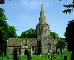
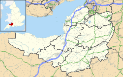
 Location within Somerset
General information Town or city Doulting Country England Coordinates 51°11′09″N 2°30′21″W / 51.1859°N 2.5058°W Completed 12th century The Church of St Aldhelm in Doulting, Somerset, England dates from the 12th century. It is a Grade I listed building.[1]
The church has a tall spire rather than the towers which are more usual in Somerset. It has a two-storey porch which incorporates a carving of the Green Man into its vaulting.[2]
The dedication to St Aldhelm is unusual and arises from the 8th century when King Ine of Wessex gave the local estate to Glastonbury Abbey after his nephew Aldhelm died in the village in 709.[2][3] In his honour the local spring which is the source of the River Sheppey is called St Aldhelm's Well.[4][5]
In August 2007 the graveyard of the church was excavated using a mechanical digger in order to install a septic tank for a toilet in the church. Local residents were outraged when they saw the digger had dug through ancient graves, destroying human remains. The controversy caused locals to stage a protest to voice their objection and attempt to stop the work from taking place.[6]
See also
- List of Grade I listed buildings in Mendip
- List of towers in Somerset
References
- ^ "Church of St Aldhelm". Images of England. http://www.imagesofengland.org.uk/details/default.aspx?id=268328. Retrieved 2006-11-25.
- ^ a b Scott, Shane (1995). The hidden places of Somerset. Aldermaston: Travel Publishing Ltd. p. 58. ISBN 1902007018.
- ^ Powicke, Sir F. Maurice (editor) [1939] (1961). Handbook of British Chronology, p. 254. London: The Royal Historical Society.
- ^ "Well head with pump at NGR ST 6468 4318". Images of England. http://www.imagesofengland.org.uk/Details/Default.aspx?id=268343. Retrieved 2008-03-17.
- ^ "Doulting Conservation Area Appraisal". Mendip Council. http://www.mendip.gov.uk/Documents/Doulting%20CAA%20August%202006.pdf. Retrieved 20 November 2010.
- ^ "BBC - Somerset - So Somerset - Neighbours protest to stop workmen disturbing their ancestors' graves". BBC News Article. http://www.bbc.co.uk/somerset/content/articles/2007/08/30/church_bones_feature.shtml. Retrieved 2009-07-29.
Categories:- Church of England churches in Mendip
- Grade I listed churches
- Grade I listed buildings in Somerset
- 12th-century church buildings


Wikimedia Foundation. 2010.