- Church of All Saints, Alford
-
Church of All Saints 
Location: Alford, Somerset, England Coordinates: 51°05′29″N 2°33′58″W / 51.09139°N 2.56611°WCoordinates: 51°05′29″N 2°33′58″W / 51.09139°N 2.56611°W Built: 15th century Listed Building – Grade I Designated: 24 March 1961[1] Reference #: 261935 
 Location of Church of All Saints in Somerset
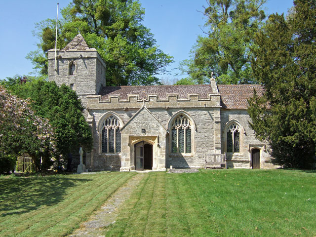
The Church of All Saints which is next to the River Brue in Alford, Somerset, England dates from the 15th century, with minor 19th-century restoration. It has been designated as a Grade I listed building.[1]
The church has a 2-bay chancel and 3-bay nave and a south porch.[1] The 2-stage tower, which is at the west end of the church contains a bell dating from 1753 and made by Thomas Bilbie of the Bilbie family.[2]
The fittings include a Jacobean pulpit, dated 1625, and 16th-century benchends.[3] The north windows have medieval stained glass including a large figure of Mary Magdalene.[1]
The parish is part of the Six Pilgrims Benefice, which also includes Babcary, Hornblotton, Lovington, North Barrow and South Barrow and is part of Wells Archdeanery.[4]
See also
- List of Grade I listed buildings in South Somerset
- List of towers in Somerset
References
- ^ a b c d "Church of All Saints". Images of England. http://www.imagesofengland.org.uk/Details/Default.aspx?id=261935. Retrieved 5 October 2007.
- ^ Moore, James; Roy Rice & Ernest Hucker (1995). Bilbie and the Chew Valley clock makers. The authors. ISBN 0952670208.
- ^ "Alford All Saints". Dawson Heritage. http://www.dawsonheritage.co.uk/somerset_churches/church.asp?ChooseChurch=Alford%20All%20Saints. Retrieved 11 September 2011.
- ^ "All Saints Alford". Church of England. http://www.achurchnearyou.com/alford-all-saints/. Retrieved 11 September 2011.
Categories:- Church of England churches in Somerset
- 15th-century architecture
- Grade I listed churches
- Grade I listed buildings in Somerset
- South Somerset

Wikimedia Foundation. 2010.