- Northwest Alabama Regional Airport
-
Northwest Alabama Regional Airport 
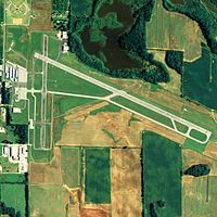
NAIP aerial image, 2006 IATA: MSL – ICAO: KMSL – FAA LID: MSL Summary Airport type Public Owner Colbert & Lauderdale Counties Serves Muscle Shoals, Alabama Elevation AMSL 551 ft / 168 m Coordinates 34°44′43″N 087°36′37″W / 34.74528°N 87.61028°WCoordinates: 34°44′43″N 087°36′37″W / 34.74528°N 87.61028°W Website Map Location of airport in Alabama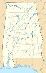
 MSL
MSLRunways Direction Length Surface ft m 11/29 6,694 2,040 Asphalt 18/36 4,000 1,219 Asphalt Statistics (2010) Aircraft operations 44,490 Based aircraft 57 Source: Federal Aviation Administration[1] Northwest Alabama Regional Airport (IATA: MSL, ICAO: KMSL, FAA LID: MSL) is a public-use airport in Colbert County, Alabama, United States. It located one nautical mile (2 km) east of the central business district of Muscle Shoals. The airport is operated by the counties of Colbert and Lauderdale.[1] It is mostly used for general aviation, but is also served by one commercial airline. Service is subsidized by the Essential Air Service program.
As per Federal Aviation Administration records, the airport had 8,680 passenger boardings (enplanements) in calendar year 2010, an increase of 25.9% from the 6,897 enplanements in 2009.[2] This airport is included in the FAA's National Plan of Integrated Airport Systems for 2011–2015, which categorized it as a non-primary commercial service airport (between 2,500 and 10,000 enplanements per year).[3]
Contents
History
Military
The airport was opened in February 1940, however in 1942 it was taken over by the United States Army Air Forces as a World War II pilot training military airfield. It was assigned to the AAF Flying Training Command, Southeast Training Center (later Eastern Flying Training Command) as a basic (stage 2) pilot training airfield.
Instruction at the school consisted of teaching the cadets to fly in formation, fly by instruments or by aerial navigation, fly at night, and fly for long distances. Aviation Cadets who washed out of pilot training were usually sent to navigator or bombardier school. The initial aircraft complement numbered 24 Vultee BT-13 Valiant and BT-15 aircraft. The ten-week course consisted of 70 hours of flight training and 150 hours of ground training.
Pilot training at the airfield apparently ended on 30 May 1944, with the drawdown of AAFTC's pilot training program. The airfield was returned to civil control at the end of the war.
Recent
Prior to Summer 2009, Muscle Shoals was served from Northwest Airlines' hub in Memphis. After Northwest was acquired by Delta, service was transferred to the company's larger hub in Atlanta. This has seen increased passenger numbers and less market leakage to nearby Huntsville Airport. Despite the increase in enplanements, on November 23, 2010, Delta announced that it would not re-apply for the Essential Air Service subsidy to serve Muscle Shoals. The cited reason was the retirement of partner Mesaba's Saab 340 fleet. Under federal law, Delta Connection must continue service to Muscle Shoals until a replacement carrier is found.[4] In 2011, Air Choice One, a Missouri-based carrier, has submitted a proposal to the US DOT to serve Muscle Shoals to either Atlanta, Nashville, or Memphis. If the proposal is accepted, the airline plans to begin the air link in as little as 30 days.[5]
Facilities and aircraft
Northwest Alabama Regional Airport covers an area of 640 acres (259 ha) at an elevation of 551 feet (168 m) above mean sea level. It has two asphalt paved runways: 11/29 is 6,694 by 150 feet (2,040 x 46 m) and 18/36 is 4,000 by 100 feet (1,219 x 30 m).[1]
For the 12-month period ending November 30, 2010, the airport had 44,490 aircraft operations, an average of 121 per day: 94% general aviation, 3% military, 2% scheduled commercial, and 1% air taxi. At that time there were 57 aircraft based at this airport: 54% single-engine, 26% multi-engine, 11% jet, and 9% helicopter.[1]
Airline and destinations
Airlines Destinations Delta Connection operated by Pinnacle Airlines Atlanta See also
References
 This article incorporates public domain material from websites or documents of the Air Force Historical Research Agency.
- Shaw, Frederick J. (2004), Locating Air Force Base Sites History’s Legacy, Air Force History and Museums Program, United States Air Force, Washington DC, 2004.
- Manning, Thomas A. (2005), History of Air Education and Training Command, 1942–2002. Office of History and Research, Headquarters, AETC, Randolph AFB, Texas ASIN: B000NYX3PC
Essential Air Service documents (Docket Number 7856) from the U.S. Department of Transportation:
- Order 2011-6-22: requesting proposals from carriers interested in providing essential air service (EAS) at Muscle Shoals, with or without subsidy. On June 1, Gulfstream notified the Department that it was withdrawing its offer to serve Muscle Shoals as a result of failed negotiations to obtain a code-share agreement with Delta Air Lines, Inc. (Delta).
- Order 2011-3-26: selecting Gulfstream International Airlines to provide essential air service (EAS) at Muscle Shoals, Alabama, for a two-year period beginning when it inaugurates full EAS, through the end of the 24th month thereafter for an annual subsidy of $2,553,283.
- Order 2010-10-13: requesting proposals from carriers interested in providing essential air service (EAS) at Muscle Shoals, for a new two-year period beginning February 1, 2011, with or without subsidy.
- Order 2008-10-17: re-selecting Mesaba Airlines, Inc., d/b/a Northwest Airlink, to provide essential air service (EAS) at annual subsidy rate of $1,782,928 at Muscle Shoals, Alabama, through January 31, 2011.
Notes
- ^ a b c d FAA Airport Master Record for MSL (Form 5010 PDF). Federal Aviation Administration. Effective 25 August 2011.
- ^ "Primary, Non-primary Commercial Service, and General Aviation Airports (by State) (PDF, 5.4 MB)". CY 2010 Passenger Boarding and All-Cargo Data. Federal Aviation Administration. 4 October 2011. http://www.faa.gov/airports/planning_capacity/passenger_allcargo_stats/passenger/media/cy10_all_enplanements.pdf.
- ^ "2011–2015 NPIAS Report, Appendix A (PDF, 2.03 MB)". 2011–2015 National Plan of Integrated Airport Systems. Federal Aviation Administration. 4 October 2010. http://www.faa.gov/airports/planning_capacity/npias/reports/media/2011/npias_2011_appA.pdf.
- ^ Patterson, Jerrita (23 November 2010). "Delta Airlines Opts Out of Servicing the Muscle Shoals Airport". WHNT News 19. http://www.whnt.com/news/shoals/whnt-shoals-delta-airlines-pulling-out-112210,0,622248.story.
- ^ McLaughlin, Budd (14 October 2011). "Missouri air carrier proposes serving Northwest Alabama Regional Airport". The Huntsville Times. http://blog.al.com/huntsville-times-business/2011/10/missouri_air_carrier_proposes.html.
External links
- Northwest Alabama Regional Airport, official site
- Aerial image as of 8 February 1999 from USGS The National Map
- FAA Terminal Procedures for MSL, effective 20 October 2011
- Resources for this airport:
- AirNav airport information for KMSL
- ASN accident history for MSL
- FlightAware airport information and live flight tracker
- NOAA/NWS latest weather observations
- SkyVector aeronautical chart, Terminal Procedures for KMSL
 Army Air Forces Training Command
Flying Training Flying Schools Eastern Flying Training Command · Central Flying Training Command · Western Flying Training CommandSpecialized Schools Bombardier · Contract Flying · Glider Training · Gunnery · Navigator
Technical Training Eastern Technical Training Command · Central Technical Training Command · Western Technical Training CommandCategories:- 1940 establishments
- Airports in Alabama
- Buildings and structures in Colbert County, Alabama
- Essential Air Service
- Florence – Muscle Shoals metropolitan area
- Airfields of the United States Army Air Forces in Alabama
- USAAF Southeast Training Center
- Transportation in Colbert County, Alabama


Wikimedia Foundation. 2010.