- Chiefdoms of Hispaniola
-
 Chiefdoms of Hispaniola
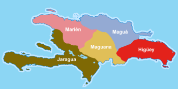
The chiefdoms of Hispaniola (cacicazgo in Spanish) delineated the island of Hispaniola (Quisqueya in Taíno) into five independent territories at the time of their discovery by the Spaniards in 1492. Each was governed by a cacique who held absolute power over their people. The Taíno inhabitants were of Arawak origin and were the first people to greet the Spanish. At the time, the Tainos were being defeated by a rival group, the Caribs. In 1508, there were about 60,000 Taínos in the island of Hispaniola, by 1531 exploitation and disease had reduced the number to 600.
The boundaries of each cacique were clear and precise, the first inhabitants of the island in fact used the natural elements such as references, such as major rivers, high mountains, notable valleys and plains. This made it possible to establish the extent of each territory.[1] Each was divided into cacique nitaínos, subdivisions headed by the cacique helpers. The entries below relate the territory of each former cacique to the provinces of the present day Dominican Republic and Haiti.
Contents
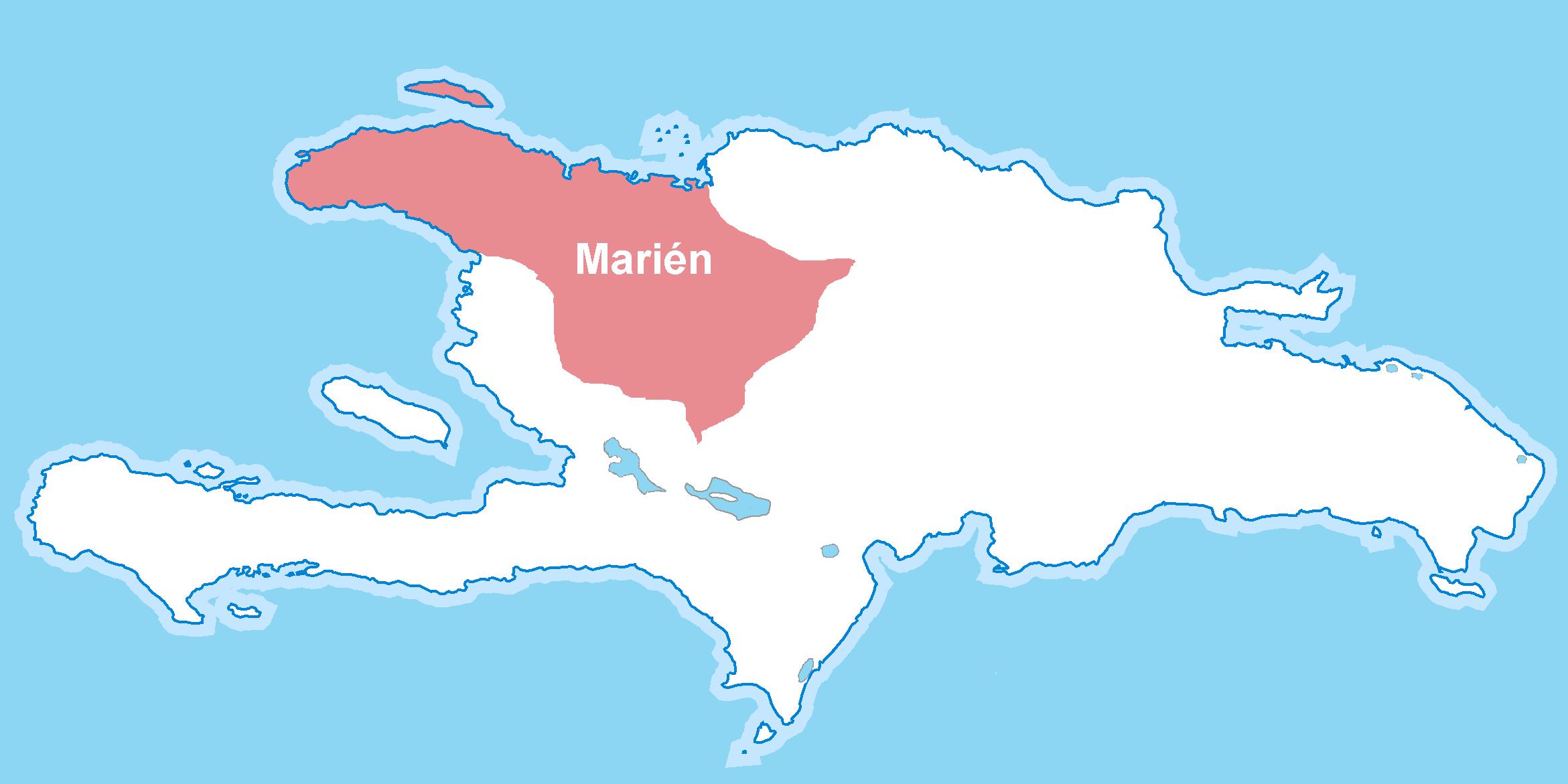
Chiefdom of Marién
 cacique of Marién
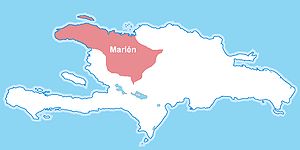
The cacique of Marién (cacicazgo of Marién) included the entire northwestern part of Hispaniola, bordered to the north by the Atlantic Ocean, the south by the cacique of Jaragua, east by the caciques of Maguá and Maguana, and west by the Windward Passage.
It was ruled by the cacique Guacanagaríx, with headquarters located in El Guarico, near the present city Haiti enemies of Cap-Haïtien . It was divided into 14 nitaínos. This cacique was the first to welcome Christopher Columbus and to convert to Christianity.
The cacique of Marién fought against the cacique Mairena, aided by Caonabo of the cacique of Maguana for control of the mythical goddess 'Mother' Iermao the cacique of Marien. The 'Mother' Iermao was the goddess of the cacique of Marién, which means "body stone".
For this battle, Guacanagaríx allied with the Spanish conquistadors to defeat an alliance of Mairena and Caonabo and thus remain the principal cacique of the whole and the cacique of Marién mythical place of Chacuey.
Geographic scope
Dominican Republic
Haiti
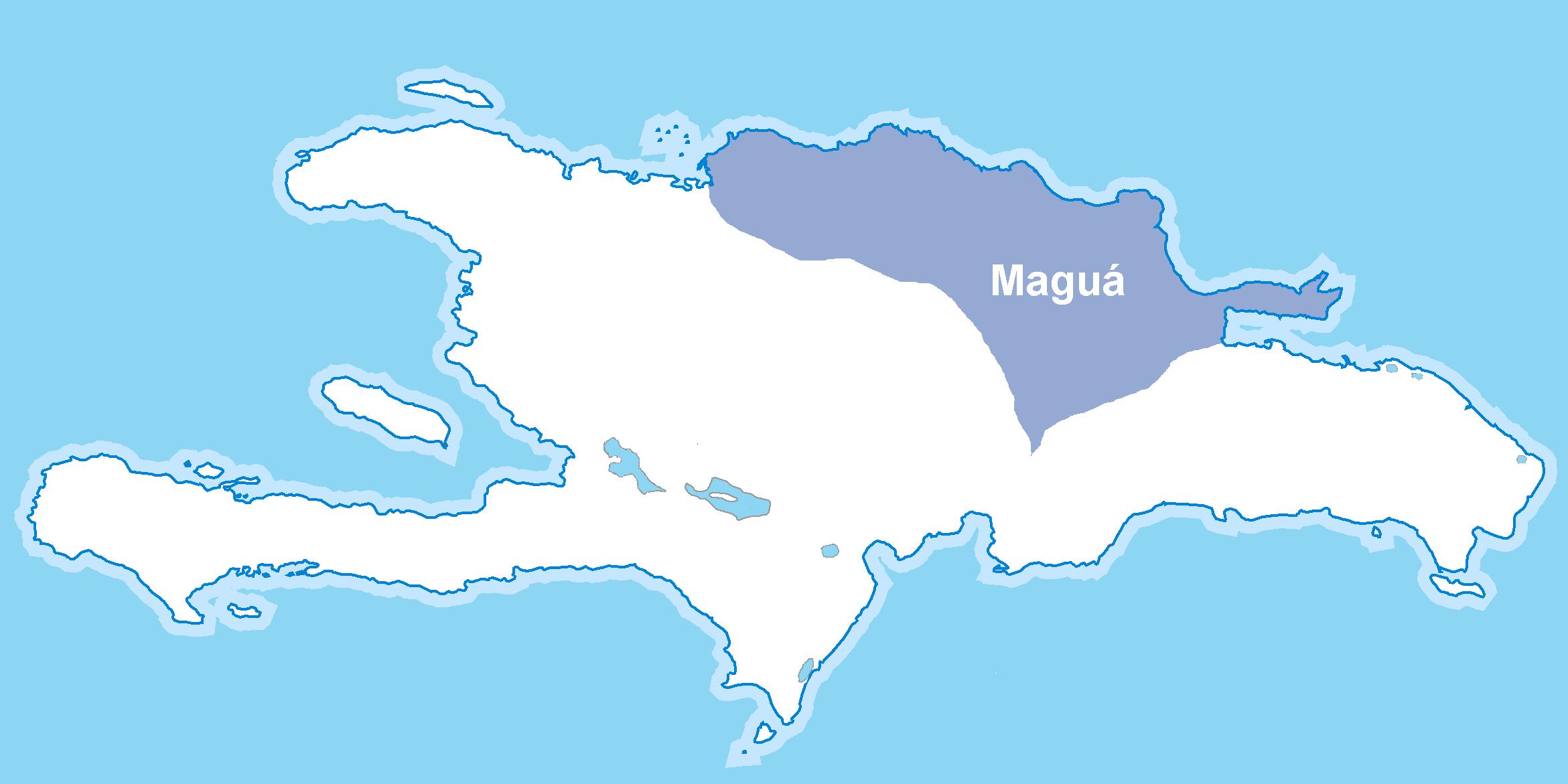
Chiefdom of Maguá
 chiefdoms in Maguá
The cacique of Maguá (cacicazgo Magu) was on the whole northeastern part of Hispaniola, bordered to the north and east by the Atlantic Ocean, the south by the caciques of Maguana and Higüey, and west by the caciques of Marién and Maguana. This chiefdom covered only the territories of the current Dominican Republic.
It was ruled by the cacique Guarionex, which is headquartered near the present location of Santo Cerro in La Vega. It was divided into 21 nitaínos. This cacique was one of the richest regions of the island.
Magua has the meaning: "the Stone" and his mother-goddess was Guacara or the 'Stone Mother'.
Geographic scope
Dominican Republic
- Duarte
- Espaillat
- La Vega
- María Trinidad Sánchez
- Monseñor Nouel
- Puerto Plata
- Hermanas Mirabal
- Samaná
- Sánchez Ramírez
- Santiago
Chiefdom of Maguana
 cacique of Maguana
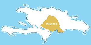
The cacique of Maguana (cacicazgo of Maguana) was the center of the Quisqueya island, bounded on the north by the caciques of Marién and Maguá, south by the Caribbean, east by the caciques of Maguá and Higüey, and west by the caciques of Marién and Jaragua. This cacique only covered the territories of the current Dominican Republic].
It was ruled by the cacique Caonabo, husband of Anacaona. Its headquarters was established at the place called Corral de los Indios in Juan de Herrera of San Juan. It was divided into 21 nitaínos. This province is devoted to the art of war.
This was the principal cacique of the island and was represented by "Peter". The term Maguana means "the first stone, the unique stone". His mother goddess was apito, which means "Mother of Stone".[2]
The cacique Caonabo was the first resistance against the Spanish occupation. This chief is accused of being responsible for the destruction of Fort La Navidad, the first Spanish settlement on American soil, installed by Christopher Columbus to the inability to repatriate all of his men to Spain during his first voyage. Because of this attack and the attempted assault of Fort Saint-Thomas, Caonabo was taken prisoner. Alonso de Ojeda tricked him into believing that he would offer her golden shackles.[clarification needed] Caonabo was handcuffed and transferred to La Isabela, then sent to Spain. The chief died in a shipwreck while crossing.[3]
Geographic scope
Dominican Republic
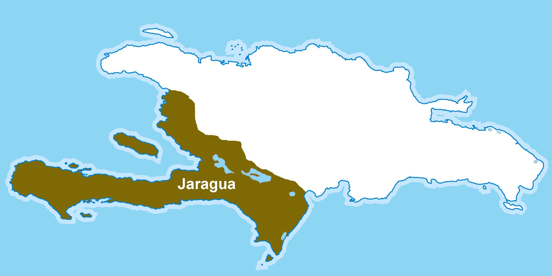
Chiefdom of Jaragua
 chiefdoms Jaragua
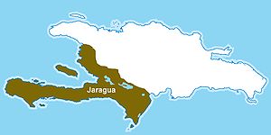
The cacique of Jaragua (cacicazgo Jaragua) spanned the entire south-west of the island of Hispaniola. It was bounded on the north by the cacique of Marién, south by the Caribbean, east by the caciques of Marién and Maguana, and west by the Strait of Jamaica .
It was ruled by the cacique Bohechio. It was the largest of the island. Its headquarters was located in a place called Yaguana, near present-day Port-au-Prince, capital of Haiti. It was divided into 26 nitaínos.
Bohechío, brother of Anacaona, was to reside at Yaquimo within the chiefdoms of Xaragua because it would support a war against two very primitive, the original inhabitants of the island, some being located in the region of rivers Las Cuevas and Yubo and the other being at the extreme southwest of the island, in a place called Guacayarima. This required Bohechío to enter a double alliance, first with the cacique of Haniguayagua for the control of the Aborigines of South-West and, on the other hand, with Caonabo for control and access to the ceremonial site of Yubo, the main island.
The mother goddess of the Xaragua cacique was Zuimaco, derived from the union of Xaragua: Zui and Yaquimo: Maco.
Geographic scope
Dominican Republic
Haiti
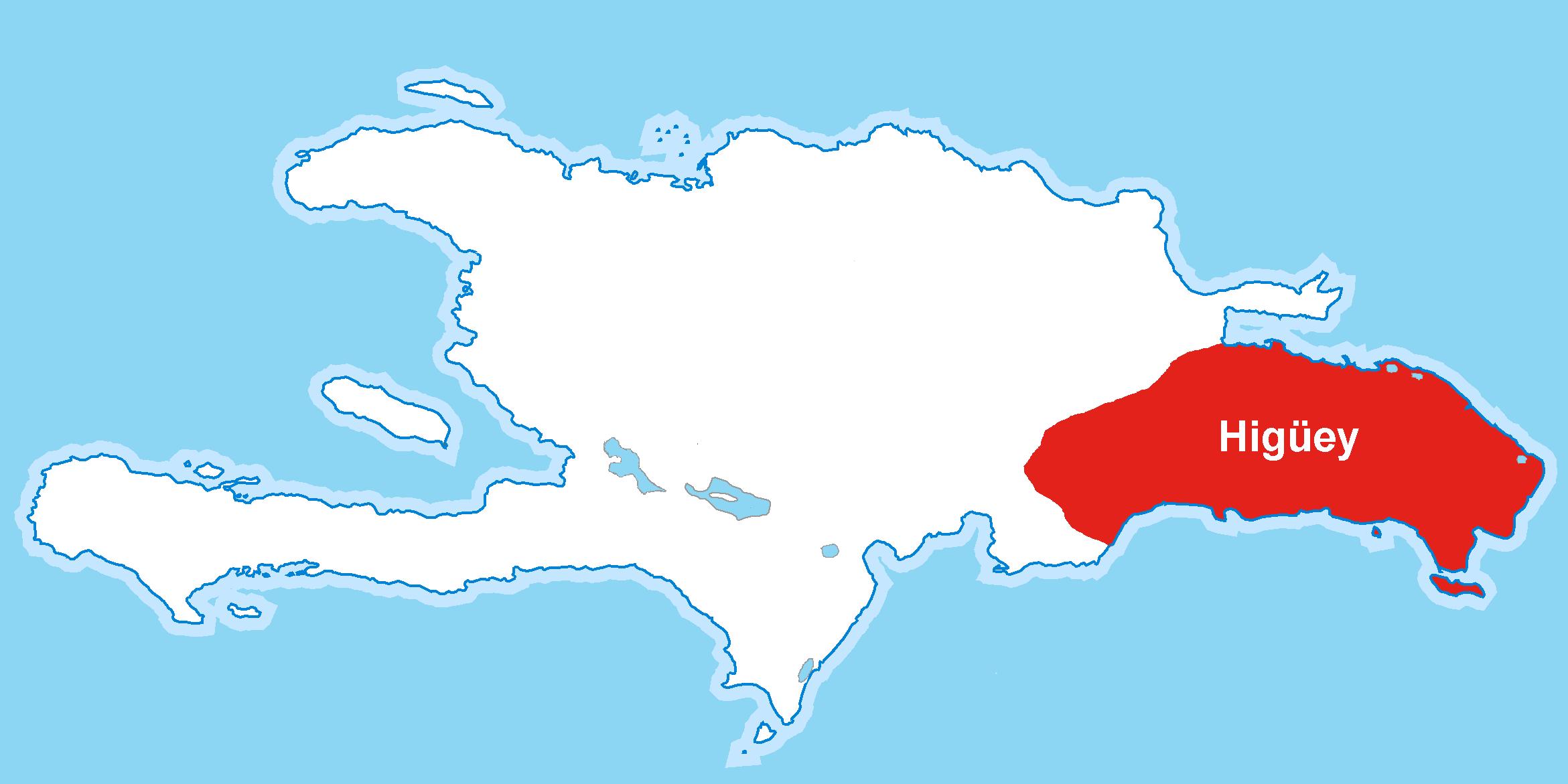
Chiefdom of Higüey
 chiefdoms Higüey
The cacique of Higüey (cacicazgo Higüey) spanned the entire southeast of Hispaniola, bordered to the north by the cacique of Maguá and the Bay Samana, south by the Caribbean, east by the Canal de la Mona, and west by the cacique of Maguana and Maguá. This cacique only covered the territories of the current Dominican Republic.
It was ruled by the cacique Cayacoa. Its headquarters was located in present-day Higüey. This cacique extended from Cabo Engaño to the river Haina. It was divided into 21 nitaínos. This cacique is also known as the Higüanamo.
The mother goddess of Higüey was Atabeira, which means "Mother of the original stone".
Geographic scope
Dominican Republic
References
- ^ (Spanish) Las Casas, Bartolomé de (1552),A Short Account of the Destruction of the Indies "Los reinos que había en la isla Española"
- ^ (Spanish) Maguana.net
- ^ (Spanish) Maguana.net
Bibliography
- Las Casas, Bartolomé de (1552) Brevísima relación of destrucción de las Indias, Axel Springer ISBN 84-7700-006-9 SL
- Fombrun, Odette Roy (2006) History of my country, Haiti 1 ISBN 978-99935-0-133-6
Categories:- Indigenous topics of the Caribbean
- History of Hispaniola
- History of Haiti
- History of the Dominican Republic
- History of indigenous peoples of North America
- Taíno


Wikimedia Foundation. 2010.