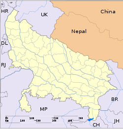
- Chhitauni
-
Chhitauni — village — Coordinates 27°7′0″N 83°59′0″E / 27.116667°N 83.983333°ECoordinates: 27°7′0″N 83°59′0″E / 27.116667°N 83.983333°E Country India State Uttar Pradesh District(s) Kushinagar Time zone IST (UTC+05:30) Area
• 81 metres (266 ft)
Codes-
• Pincode • 274801
Chhitauni is a village in Kushinagar district of Uttar Pradesh, India.
Contents
Geography
It is located at 27°7′0″N 83°59′0″E / 27.116667°N 83.983333°E at an elevation of 81 m above MSL.[1]
Location
National Highway 28B passes through Chhitauni.
References
External links
Categories:- Uttar Pradesh geography stubs
- Villages in Deoria district
-
Wikimedia Foundation. 2010.


