- Charters Towers Airport
-
Charters Towers Airport 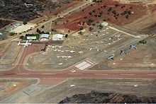
Airport overview
 Charters Towers
AirportCharters Towers
Airport (Queensland)IATA: CXT – ICAO: YCHT Summary Location Charters Towers, Queensland Elevation AMSL 955 ft / 291 m Coordinates 20°02′35″S 146°16′23″E / 20.04306°S 146.27306°E Runways Direction Length Surface ft m 19/01 3,297 1,005 24/06 5,699 1,737 Charters Towers Airport (IATA: CXT, ICAO: YCHT) is an airport located north of Charters Towers, Queensland, Australia.
Contents
History
World War II
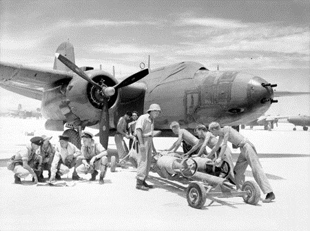
 No. 22 Squadron aircrew and ground crew preparing for a sortie in October 1944
During World War II, the United States Army Air Force Fifth Air Force stationed the following units at the airfield:[1][2]
- 3d Bombardment Group, (10 March 1942 – 28 January 1943) (Headquarters)
- 8th Bombardment Squadron, A-20 Havoc (17-31 March 1942; 9 May 1942 – 28 January 1943)
- 90th Bombardment Squadron, A-20 Havoc (8 March 1942 – 28 January 1943)
- 431st Fighter Squadron (475th Fighter Group), P-38 Lightning (14 May-1 July 1943)
- 432d Fighter Squadron (475th Fighter Group), P-38 Lightning (14 May-11 July 1943)
- 433d Fighter Squadron (475th Fighter Group), P-38 Lightning (14 May-17 June 1943)
- 16th Bombardment Squadron (Light) (27th Bombardment Group (Light)), A-24 Dauntless (1 April-4 May 1942)
- 17th Bombardment Squadron (Light) (27th Bombardment Group (Light)), A-24 Dauntless (1 April-4 May 1942)
- 91st Bombardment Squadron (Light) (27th Bombardment Group (Light)), A-24 Dauntless (24 March 1942)
In addition, 370th Service Squadron managed the day to day USAAF Base operations of the airfield.
See also
- United States Army Air Forces in Australia (World War II)
References
 This article incorporates public domain material from websites or documents of the Air Force Historical Research Agency.
- ^ Mauer, Mauer (1969), Combat Squadrons of the Air Force, World War II, Air Force Historical Studies Office, Maxwell AFB, Alabama. ISBN 0-89201-097-5
- ^ Maurer, Maurer (1983). Air Force Combat Units Of World War II. Maxwell AFB, Alabama: Office of Air Force History. ISBN 0-89201-092-4.
External links
Categories:- Airports in Queensland
- Airfields of the United States Army Air Forces in Australia
- Queensland airport stubs


Wikimedia Foundation. 2010.