- Châlons Vatry Airport
-
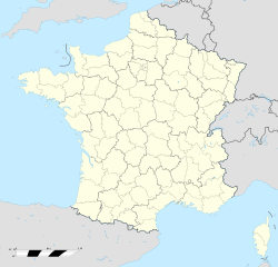
Châlons Vatry Airport IATA: XCR – ICAO: LFOK Location of airport in France Summary Airport type Public Operator Société d’Exploitation Vatry Europort (SEVE) Serves Châlons-en-Champagne Location Vatry, Marne, France Elevation AMSL 586 ft / 179 m Coordinates 48°46′24″N 004°12′22″E / 48.77333°N 4.20611°E Website Runways Direction Length Surface m ft 10/28 3,860 12,664 Concrete Sources: French AIP[1], UAF[2], DAFIF[3][4] Châlons Vatry Airport (IATA: XCR, ICAO: LFOK) is an airport serving Châlons-en-Champagne (formerly Châlons-sur-Marne) in northeastern France. The airport is located 22 km (14 mi) southeast of Châlons-en-Champagne, near Vatry, in the Marne department of France.[1] It is also known as Vatry International Airport or Paris Vatry Airport. It is also marketed as Paris Vatry (Disney) by Ryanair, the airport being located approx. 105 km (65 mi) from the famous theme park.
The airport is primarily used for international air cargo transport.
Contents
History
Châlons Vatry Airport's origins began in 1950 when, with the Cold War, NATO faced several problems when attempting to solve the air power survival equation. Planning for first strike survival in both conventional and nuclear wars had to be considered.
Construction began in 1953, and Vatry Air Base was designed for 50 fighters with three large hangars constructed. With the French withdrawal from the integrated NATO military structure in 1967, the American forces left Vatry Air Base and it was closed.
For many years, Vatry Air Base was under the control of the French Air Force and used for a training facility. About 2000 it was sold to civil interests and today is being used as an international heavy cargo and commercial passenger airport.[5]
Airlines and destinations
Airlines Destinations Ryanair Porto
Seasonal: Rygge, Stockholm-SkavstaCargo Airlines and destinations
Airlines Destinations Cargolux Luxembourg, Newark UPS Airlines Atlanta, London-Stansted Facilities
The airport is 586 feet (179 m) above mean sea level. It has one paved runway designated 10/28 which measures 3,860 by 45 metres (12,664 × 148 ft).[1]
References
- ^ a b c LFOK – Chalons Vatry (PDF). AIP from French Service d'information aéronautique, effective 17 Nov 2011.
- ^ Aéroport de Paris Vatry (XCR /LFOK) at Union des Aéroports Français
- ^ Airport information for LFOK from DAFIF (effective October 2006)
- ^ Airport information for XCR at Great Circle Mapper. Source: DAFIF (effective Oct. 2006).
- ^ Vatry International Airport at Sovereign-Publications.com
External links
Categories:- Airports in France
- Marne
Wikimedia Foundation. 2010.

