- A26 autoroute
Infobox road
marker_
highway_name=
maint=SANEF
highway_name=
maint=SANEF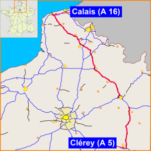
length_km=394
established=
direction_a=North
direction_b=South
starting_terminus=Calais
ending_terminus=Troyes
junction=
system=EuroRoute|E|15 EuroRoute|E|17 The A26 is a 394 km (245 mile) long French motorway connectingCalais andTroyes . It is also known as the Autoroute des Anglais as it is the main route from theDover -Calais ferries and thechannel tunnel to most parts of France and often contains large numbers of British cars, particularly during the summer holiday season. Before the opening of the A16 in the 1990s the A26 formed part of the road route betweenLondon andParis .The road forms part of
European route E-15 and E-17.Route
The motorway starts at Calais, at a junction with the A16 and
N216 (which links to the Car Ferries). From there it runs southeast pastSaint-Omer ,Béthune , Lens andArras . Near Arras is a major intersection with the A1, which runs south to Paris.The A26 continues southeast, passing near
Cambrai , Saint-Quentin andLaon before meeting the A4 atReims . The two motorways merge (overlap) for 36 km (23 miles) before splitting up near Châlons en Champagne (formerly Châlons-sur-Marne), with the A26 heading south. The terminus is at Troyes, where the A26 meets the A5, which provides connections to southern and eastern France.Junctions
* , A216 spur to RN216 and the Calais Ferry Port, and the A26.
** Rest Area: Nortkerque (Northbound), Zutkerque (Southbound)
* 2 "Nordausques": Ardres
*
** Péage Saint-Omer
*
** Rest Area: Grand Riez / Villefleur
** Service Area: Rely / St-Hilaire-Cottes
* and Saint Pol-sur-Ternoise
** Rest Area: Le Réveillon / La Grande Bucaille
*
*
** Service Area;: Souchez / Angres
*
** Rest Area: Les Trois Crêtes / La Cressonière
* with A26
** Rest Area: Bonnettes (southbound) Bois-Dhuez (Northbound)
** Service Area: Rumaucourt (Southbound) Baralle (Northbound)
*
* (Paris to Brussels) with A26
** Rest Area: Plateau (Southbound) Vacquerie (Northbound)
*
** Rest Area: La Haute Bruyère L'Omignon
*
* (Rouen) with A26
*
** Service Area: Urvillers
* 12 "Courbes": La Fere
** Rest Area: St Brice / Broyon
*
** Rest Area: la Croisette (Southbound) Les Pélerins (Northbound)
** Service Area: Mont-de-Nizy / Champ-Roland
*
** Rest area: Cauroy / Loivre
** Péage Courcy
*, Reims-Champagne Airport
*16 "Reims - Colbert": Reims
* (Paris to Strasbourg) with A26* (Paris to Strasbourg) with A26
** Rest Area:Les Grands Traquiers (Southbound)
*
** Rest Area: La Garenne (Northbound)
* and Fère-Champenoise
** Rest Area: La Bardolle (Northbound)
*19 "Europort Vatry": Europort Business park
*)
** Service Area: Sommesous
** Rest Area: Le Champ du Carreau / Champ-L'Épée
* and Brienne-le-Château
** Service Area: St Arcis-sur-Aube
*
** Rest Area: Villechétif / Les Crocs de la Terre
* 23 "Thennelières": Troyes, Vendeuvre-sur-Barse and "Parc Naturel Regional De La Forêt D'Orient"
* (Paris to Dijon) with A26Future
The A26 may eventually be extended towards
Auxerre andBourges to link up with the A6 and provide a more direct route toLyon .External links
* [http://saratlas.free.fr/index.php?page=autoroute&route=a26&lang=en A26 autoroute in Saratlas]

Wikimedia Foundation. 2010.