Chalky Island, New Zealand

Chalky Island, New Zealand
Chalky Island

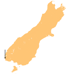
Location map of Chalky Island.
Geography
Location Southland Region
Coordinates 46°03′S 166°31′E / 46.05°S 166.517°E / -46.05; 166.517
Area 5.14 km2 (1.985 sq mi)
Country
Demographics
Population 0

Chalky Island is a 514 hectares (1,270 acres) island in the southwest of New Zealand, and is part of Fiordland National Park. It lies at the entrance to Chalky Inlet, at the southwestern tip of the South Island, 10 kilometres (6 mi) northwest of Puysegur Point, 15 kilometres (9 mi) southeast of West Cape, and 140 kilometres (87 mi) west of Invercargill.

The island was first charted by Captain James Cook in 1773, and was a base for sealers in the late 18th and early 19th centuries.

All predators were eradicated from the island by the New Zealand Department of Conservation, and it is now used as a bird sanctuary. Until 2005 it was one of only four refuges of the flightless native parrot, the Kakapo.[1]

Coordinates: 46°03′S 166°31′E / 46.05°S 166.517°E / -46.05; 166.517

See also

References

External links


Wikimedia Foundation. 2010.

Игры ⚽ Нужно решить контрольную?

Look at other dictionaries:

  • Chalky Island (New Zealand) — Chalky Island is a 514 ha island in the southwest of New Zealand, and is part of Fiordland National Park. It lies at the entrance to Chalky Inlet, at the southwestern tip of the South Island, ten kilometres northwest of Puysegur Point, 15… …   Wikipedia

  • Chalky Island — may refer to: Chalky Island (New Zealand) Chalky Island (Tasmania) Little Chalky Island, Tasmania This disambiguation page lists articles about distinct geographical locations with the same name. If an …   Wikipedia

  • New Zealand parrot — New Zealand Kaka, North Island subspecies (Nestor meridionalis septentrionalis) at Auckland Zoo, New Zealand Scientific classification …   Wikipedia

  • New Zealand wine — Map showing major cities and approximate location of the main NZ wine growing areas New Zealand wine is largely produced in ten major wine growing regions spanning latitudes 36° to 45° South and extending 1,600 kilometres (990 mi). They are …   Wikipedia

  • 1822 in New Zealand — IncumbentsRegal and Vice Regal*Head of State – King George IV *Governor of New South Wales – Major General Sir Thomas Brisbane Events *22 January – Samuel Leigh and his wife arrive in the Bay of Islands to start the first Wesleyan mission. They… …   Wikipedia

  • List of islands of New Zealand — New Zealand consists of a large number of islands. The two main islands, which are much larger than the rest and where most of the population lives, are the North Island and the South Island. The latter is often a little ironically referred to as …   Wikipedia

  • Marton, New Zealand — …   Wikipedia

  • Kakapo — Conservation status Critically Endangered ( …   Wikipedia

  • Eulenpapagei — Kakapo Kakapo (Strigops habroptilus) Systematik Klasse: Vögel (Aves) Ordnung …   Deutsch Wikipedia

  • Eulenpapageien — Kakapo Kakapo (Strigops habroptilus) Systematik Klasse: Vögel (Aves) Ordnung …   Deutsch Wikipedia

Share the article and excerpts

Direct link
Do a right-click on the link above
and select “Copy Link”