- Elk River Chain of Lakes Watershed
-
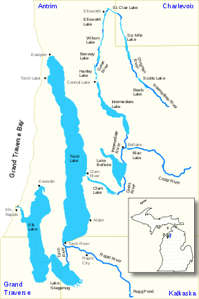
The Elk River Chain of Lakes Watershed is a seventy-five mile-long waterway consisting of fourteen lakes and connecting rivers in the northwestern section of the Lower Peninsula of the U.S. state of Michigan.
The watershed includes 500 square miles (1,300 km2) in Antrim County, Charlevoix County, Grand Traverse County, and Kalkaska County. The watershed includes a series of fourteen lakes and interconnecting rivers. From the uppermost lake in the chain, Beals Lake in Echo Township, Antrim County, the water flows 55 miles (89 km) and drops 40 feet (12 m) in elevation. It has over 200 miles (320 km) of shoreline and almost 60 square miles (160 km2) of water surface.[1][2]
Contents
Geography
The chain of lakes system begins with the upper stage of the Intermediate River, which rises in hill country at 45°00′20″N 85°04′45″W / 45.00556°N 85.07917°W[3] in the northwest corner of Chestonia Township in central Antrim County. From here, the waterway traverses a number of small lakes flowing north, then making a sharp turn near the village of Ellsworth, flows south through a narrow valley, paralleling the tracks of the Pere Marquette Railroad, until emptying into Intermediate Lake. The outlet of Intermediate Lake converges with the Cedar River in the village of Bellaire, gaining considerable volume. Now a river of substantial flow, it continues south into 1,700-acre (6.9 km2) Lake Bellaire. Leaving the lake, the stream becomes the Grass River, winding for some two miles (3 km) through the scenic Grass River Natural Area before emptying into Clam Lake. Clam Lake in turn empties directly into Torch Lake. At over 18,000 acres (73 km2) in size, Torch Lake is the largest body of water in the system. The waterway, now clarified after traversing the immense depths of the lake, continues south through the Torch River, joins with the Rapid River, a major tributary, and empties into Lake Skegemog, a 2,500-acre (10 km2) lake that is studded with large stump fields, the result of the flooding of timberlands when the lake level was raised several feet by the construction of the dam at the terminus of the system. Lake Skegemog, which is the meeting point of Grand Traverse, Kalkaska and Antrim counties, is conjoined at its western end to 7,700-acre (31 km2) Elk Lake, the second-largest and final lake in the system. The outflow of Elk Lake, the Elk River, flows a short distance to a power dam in the town of Elk Rapids, then out into the east arm of the Grand Traverse Bay of Lake Michigan at 44°54′06″N 85°24′49″W / 44.90167°N 85.41361°WCoordinates: 44°54′06″N 85°24′49″W / 44.90167°N 85.41361°W[4]. For most of its length, “The Chain” is navigable by small boat, broken up only by a dam in Bellaire. Larger boats are able to navigate between Elk Rapids and Torch Lake.
History
Various tribes of primarily Ojibwa native Americans were inhabiting the region with the arrival of the first white settlers, who began arriving in the middle of the 19th century to attempt farming. The thin soils and short, cool summers made traditional farming difficult, and the region remained sparsely settled until the 1880s, when lumber interests began exploiting the regions vast tracts of white pine forests. The waterway provided an excellent means of transporting logs down to sawmills located along the way. The arrival of the railroads in the 1890s accelerated lumbering and other economic activities, and brought in visitors from distant places, who marveled at the natural beauty of lakes and rivers of the chain, turning it into a major destination for vacationers from downstate and elsewhere. Scores of resorts cropped up on the shorelines of all the major lakes of the system, catering to fisherman and wild-life enthusiasts. By 1910, the lumber era had all but passed, and many of the towns and villages in the area that had prospered from its riches went into decline. Many of the regions farmers, having failed to get decent yields of traditional crops, either moved on, or turned to cultivation of fruit crops, most notably cherries, as the areas sandy soil and cool lake climate were found to be quite favorable for growing such produce. Fruit farming and tourism became, and is to this day, the leading economic activities of the region.
Rivers and lakes in the watershed
The fourteen lakes (numbered) and connecting waterways in the chain of lakes are highlighted in bold. Other tributaries are in normal text
- Elk River[4]
- 1) Elk Lake[5]
- Williamsburg Creek[6]
- Battle Creek[9]
- 2) Lake Skegemog[10]
- Barker Creek[11]
- Desmond Creek[12]
- Torch River[13]
- Rapid River[14]
- 3) Torch Lake (Antrim County, Michigan)[17]
- Spencer Creek[18]
- Eastport Creek[19]
- Wilkinson Creek (also Wilkenson Creek)[20]
- 4) Clam Lake[21]
- Finch Creek[22]
- Crow Creek[23]
- Grass River[24]
- Cold Creek[25]
- Shanty Creek[26]
- 5) Lake Bellaire[27]
- Grass Creek[28]
- Intermediate River[29]
- Cedar River[30]
- 6) Intermediate Lake[34]
- Finch Creek[22]
- 1) Elk Lake[5]
Cities, villages, and townships in the watershed
The Elk River Chain of Lakes Watershed includes all or portions of the following cities, villages, and townships:
- Kalkaska County
- Clearwater Township
- Cold Springs Township
- Kalkaska
- Kalkaska Township
- Rapid River Township
See also
References
- ^ Elk River Chain of Lakes Watershed Project – CMI
- ^ Elk River Chain of Lakes, 2010 Report, Tip of the Mitt Watershed Council[
- ^ "Intermediate River". Geographic Names Information System, U.S. Geological Survey. http://geonames.usgs.gov/pls/gnispublic/f?p=gnispq:3:::NO::P3_FID:629056.
- ^ a b "Elk River". Geographic Names Information System, U.S. Geological Survey. http://geonames.usgs.gov/pls/gnispublic/f?p=gnispq:3:::NO::P3_FID:625460.
- ^ "Elk Lake". Geographic Names Information System, U.S. Geological Survey. http://geonames.usgs.gov/pls/gnispublic/f?p=gnispq:3:::NO::P3_FID:1617384.
- ^ "Williamsburg Creek". Geographic Names Information System, U.S. Geological Survey. http://geonames.usgs.gov/pls/gnispublic/f?p=gnispq:3:::NO::P3_FID:1616513.
- ^ "Bissell Pond". Geographic Names Information System, U.S. Geological Survey. http://geonames.usgs.gov/pls/gnispublic/f?p=gnispq:3:::NO::P3_FID:621464.
- ^ "Bissell Creek". Geographic Names Information System, U.S. Geological Survey. http://geonames.usgs.gov/pls/gnispublic/f?p=gnispq:3:::NO::P3_FID:621463.
- ^ "Battle Creek". Geographic Names Information System, U.S. Geological Survey. http://geonames.usgs.gov/pls/gnispublic/f?p=gnispq:3:::NO::P3_FID:620757.
- ^ "Lake Skegemog". Geographic Names Information System, U.S. Geological Survey. http://geonames.usgs.gov/pls/gnispublic/f?p=gnispq:3:::NO::P3_FID:638052.
- ^ "Barker Creek". Geographic Names Information System, U.S. Geological Survey. http://geonames.usgs.gov/pls/gnispublic/f?p=gnispq:3:::NO::P3_FID:620606.
- ^ "Desmond Creek". Geographic Names Information System, U.S. Geological Survey. http://geonames.usgs.gov/pls/gnispublic/f?p=gnispq:3:::NO::P3_FID:624578.
- ^ "Torch River". Geographic Names Information System, U.S. Geological Survey. http://geonames.usgs.gov/pls/gnispublic/f?p=gnispq:3:::NO::P3_FID:1614973.
- ^ "Rapid River". Geographic Names Information System, U.S. Geological Survey. http://geonames.usgs.gov/pls/gnispublic/f?p=gnispq:3:::NO::P3_FID:635650.
- ^ "Rugg Pond". Geographic Names Information System, U.S. Geological Survey. http://geonames.usgs.gov/pls/gnispublic/f?p=gnispq:3:::NO::P3_FID:1623091.
- ^ "Little Rapid River". Geographic Names Information System, U.S. Geological Survey. http://geonames.usgs.gov/pls/gnispublic/f?p=gnispq:3:::NO::P3_FID:630747.
- ^ "Torch Lake". Geographic Names Information System, U.S. Geological Survey. http://geonames.usgs.gov/pls/gnispublic/f?p=gnispq:3:::NO::P3_FID:1614970.
- ^ "Spencer Creek". Geographic Names Information System, U.S. Geological Survey. http://geonames.usgs.gov/pls/gnispublic/f?p=gnispq:3:::NO::P3_FID:638498.
- ^ "Eastport Creek". Geographic Names Information System, U.S. Geological Survey. http://geonames.usgs.gov/pls/gnispublic/f?p=gnispq:3:::NO::P3_FID:625302.
- ^ "Wilkinson Creek". Geographic Names Information System, U.S. Geological Survey. http://geonames.usgs.gov/pls/gnispublic/f?p=gnispq:3:::NO::P3_FID:1616484.
- ^ "Clam Lake". Geographic Names Information System, U.S. Geological Survey. http://geonames.usgs.gov/pls/gnispublic/f?p=gnispq:3:::NO::P3_FID:623327.
- ^ "Finch Creek". Geographic Names Information System, U.S. Geological Survey. http://geonames.usgs.gov/pls/gnispublic/f?p=gnispq:3:::NO::P3_FID:625951.
- ^ "Crow Creek". Geographic Names Information System, U.S. Geological Survey. http://geonames.usgs.gov/pls/gnispublic/f?p=gnispq:3:::NO::P3_FID:624136.
- ^ "Grass River". Geographic Names Information System, U.S. Geological Survey. http://geonames.usgs.gov/pls/gnispublic/f?p=gnispq:3:::NO::P3_FID:627223.
- ^ "Cold Creek". Geographic Names Information System, U.S. Geological Survey. http://geonames.usgs.gov/pls/gnispublic/f?p=gnispq:3:::NO::P3_FID:623556.
- ^ "Shanty Creek". Geographic Names Information System, U.S. Geological Survey. http://geonames.usgs.gov/pls/gnispublic/f?p=gnispq:3:::NO::P3_FID:637662.
- ^ "Lake Bellaire". Geographic Names Information System, U.S. Geological Survey. http://geonames.usgs.gov/pls/gnispublic/f?p=gnispq:3:::NO::P3_FID:621049.
- ^ "Grass Creek". Geographic Names Information System, U.S. Geological Survey. http://geonames.usgs.gov/pls/gnispublic/f?p=gnispq:3:::NO::P3_FID:1618828.
- ^ "Intermediate River". Geographic Names Information System, U.S. Geological Survey. http://geonames.usgs.gov/pls/gnispublic/f?p=gnispq:3:::NO::P3_FID:629056.
- ^ "Cedar River". Geographic Names Information System, U.S. Geological Survey. http://geonames.usgs.gov/pls/gnispublic/f?p=gnispq:3:::NO::P3_FID:622946.
- ^ "Blair Lake". Geographic Names Information System, U.S. Geological Survey. http://geonames.usgs.gov/pls/gnispublic/f?p=gnispq:3:::NO::P3_FID:621560.
- ^ "North Branch Cedar River". Geographic Names Information System, U.S. Geological Survey. http://geonames.usgs.gov/pls/gnispublic/f?p=gnispq:3:::NO::P3_FID:633497.
- ^ "Woolcott Creek". Geographic Names Information System, U.S. Geological Survey. http://geonames.usgs.gov/pls/gnispublic/f?p=gnispq:3:::NO::P3_FID:1616815.
- ^ "Intermediate Lake". Geographic Names Information System, U.S. Geological Survey. http://geonames.usgs.gov/pls/gnispublic/f?p=gnispq:3:::NO::P3_FID:629055.
- ^ "Openo Creek". Geographic Names Information System, U.S. Geological Survey. http://geonames.usgs.gov/pls/gnispublic/f?p=gnispq:3:::NO::P3_FID:2100234.
- ^ "Fisk Creek". Geographic Names Information System, U.S. Geological Survey. http://geonames.usgs.gov/pls/gnispublic/f?p=gnispq:3:::NO::P3_FID:626085.
- ^ "Hanley Lake". Geographic Names Information System, U.S. Geological Survey. http://geonames.usgs.gov/pls/gnispublic/f?p=gnispq:3:::NO::P3_FID:627728.
- ^ "Green River". Geographic Names Information System, U.S. Geological Survey. http://geonames.usgs.gov/pls/gnispublic/f?p=gnispq:3:::NO::P3_FID:1623147.
- ^ "Ogletree Creek". Geographic Names Information System, U.S. Geological Survey. http://geonames.usgs.gov/pls/gnispublic/f?p=gnispq:3:::NO::P3_FID:633962.
- ^ "Kitty Ann Creek". Geographic Names Information System, U.S. Geological Survey. http://geonames.usgs.gov/pls/gnispublic/f?p=gnispq:3:::NO::P3_FID:629776.
- ^ "Toad Lake". Geographic Names Information System, U.S. Geological Survey. http://geonames.usgs.gov/pls/gnispublic/f?p=gnispq:3:::NO::P3_FID:1614892.
- ^ "Toad Creek". Geographic Names Information System, U.S. Geological Survey. http://geonames.usgs.gov/pls/gnispublic/f?p=gnispq:3:::NO::P3_FID:1614890.
- ^ "Mud Lake". Geographic Names Information System, U.S. Geological Survey. http://geonames.usgs.gov/pls/gnispublic/f?p=gnispq:3:::NO::P3_FID:633012.
- ^ "Little Torch Lake". Geographic Names Information System, U.S. Geological Survey. http://geonames.usgs.gov/pls/gnispublic/f?p=gnispq:3:::NO::P3_FID:630429.
- ^ "Ben-way Lake". Geographic Names Information System, U.S. Geological Survey. http://geonames.usgs.gov/pls/gnispublic/f?p=gnispq:3:::NO::P3_FID:621081.
- ^ "Benway Creek". Geographic Names Information System, U.S. Geological Survey. http://geonames.usgs.gov/pls/gnispublic/f?p=gnispq:3:::NO::P3_FID:621148.
- ^ "Wilson Lake". Geographic Names Information System, U.S. Geological Survey. http://geonames.usgs.gov/pls/gnispublic/f?p=gnispq:3:::NO::P3_FID:1616583.
- ^ "Vonstraten Creek". Geographic Names Information System, U.S. Geological Survey. http://geonames.usgs.gov/pls/gnispublic/f?p=gnispq:3:::NO::P3_FID:1615625.
- ^ "King Creek". Geographic Names Information System, U.S. Geological Survey. http://geonames.usgs.gov/pls/gnispublic/f?p=gnispq:3:::NO::P3_FID:629690.
- ^ "Eaton Lake". Geographic Names Information System, U.S. Geological Survey. http://geonames.usgs.gov/pls/gnispublic/f?p=gnispq:3:::NO::P3_FID:625312.
- ^ "Ellsworth Lake". Geographic Names Information System, U.S. Geological Survey. http://geonames.usgs.gov/pls/gnispublic/f?p=gnispq:3:::NO::P3_FID:625499.
- ^ "Skinner Creek". Geographic Names Information System, U.S. Geological Survey. http://geonames.usgs.gov/pls/gnispublic/f?p=gnispq:3:::NO::P3_FID:638062.
- ^ "Skinner Lake". Geographic Names Information System, U.S. Geological Survey. http://geonames.usgs.gov/pls/gnispublic/f?p=gnispq:3:::NO::P3_FID:638067.
- ^ "Marion Creek". Geographic Names Information System, U.S. Geological Survey. http://geonames.usgs.gov/pls/gnispublic/f?p=gnispq:3:::NO::P3_FID:1618829.
- ^ "St. Clair Lake". Geographic Names Information System, U.S. Geological Survey. http://geonames.usgs.gov/pls/gnispublic/f?p=gnispq:3:::NO::P3_FID:636598.
- ^ "St. Clair Creek". Geographic Names Information System, U.S. Geological Survey. http://geonames.usgs.gov/pls/gnispublic/f?p=gnispq:3:::NO::P3_FID:636595.
- ^ "Lyman Creek". Geographic Names Information System, U.S. Geological Survey. http://geonames.usgs.gov/pls/gnispublic/f?p=gnispq:3:::NO::P3_FID:631228.
- ^ "Lymans Lake". Geographic Names Information System, U.S. Geological Survey. http://geonames.usgs.gov/pls/gnispublic/f?p=gnispq:3:::NO::P3_FID:631229.
- ^ "Sixmile Lake". Geographic Names Information System, U.S. Geological Survey. http://geonames.usgs.gov/pls/gnispublic/f?p=gnispq:3:::NO::P3_FID:638030.
- ^ "Liscon Creek". Geographic Names Information System, U.S. Geological Survey. http://geonames.usgs.gov/pls/gnispublic/f?p=gnispq:3:::NO::P3_FID:630535.
- ^ "Ranney Creek". Geographic Names Information System, U.S. Geological Survey. http://geonames.usgs.gov/pls/gnispublic/f?p=gnispq:3:::NO::P3_FID:635639.
- ^ "Vance Creek". Geographic Names Information System, U.S. Geological Survey. http://geonames.usgs.gov/pls/gnispublic/f?p=gnispq:3:::NO::P3_FID:2100361.
- ^ "Dingman River". Geographic Names Information System, U.S. Geological Survey. http://geonames.usgs.gov/pls/gnispublic/f?p=gnispq:3:::NO::P3_FID:1623146.
- ^ "Smith Creek". Geographic Names Information System, U.S. Geological Survey. http://geonames.usgs.gov/pls/gnispublic/f?p=gnispq:3:::NO::P3_FID:638136.
- ^ "Scotts Lake". Geographic Names Information System, U.S. Geological Survey. http://geonames.usgs.gov/pls/gnispublic/f?p=gnispq:3:::NO::P3_FID:637483.
- ^ "Beal Creek". Geographic Names Information System, U.S. Geological Survey. http://geonames.usgs.gov/pls/gnispublic/f?p=gnispq:3:::NO::P3_FID:620814.
- ^ "Beals Lake". Geographic Names Information System, U.S. Geological Survey. http://geonames.usgs.gov/pls/gnispublic/f?p=gnispq:3:::NO::P3_FID:620816.
- ^ "Intermediate River". Geographic Names Information System, U.S. Geological Survey. http://geonames.usgs.gov/pls/gnispublic/f?p=gnispq:3:::NO::P3_FID:629056.
- ^ "Spence Creek". Geographic Names Information System, U.S. Geological Survey. http://geonames.usgs.gov/pls/gnispublic/f?p=gnispq:3:::NO::P3_FID:638492.
- ^ "Taylor Creek". Geographic Names Information System, U.S. Geological Survey. http://geonames.usgs.gov/pls/gnispublic/f?p=gnispq:3:::NO::P3_FID:1614617.
- ^ "Seamon Creek". Geographic Names Information System, U.S. Geological Survey. http://geonames.usgs.gov/pls/gnispublic/f?p=gnispq:3:::NO::P3_FID:2100233.
- ^ "Hitchcock Creek". Geographic Names Information System, U.S. Geological Survey. http://geonames.usgs.gov/pls/gnispublic/f?p=gnispq:3:::NO::P3_FID:628355.
External links
- Elk River Watershed, Tip of the Mitt Watershed Council
- Elk River Chain of Lakes Watershed, Michigan Department of Environmental Quality
Categories:- Lakes of Michigan
- Chains of lakes
- Geography of Antrim County, Michigan
- Geography of Charlevoix County, Michigan
- Geography of Grand Traverse County, Michigan
- Geography of Kalkaska County, Michigan
- Northern Michigan
- Tributaries of Lake Michigan
- Elk River[4]

Wikimedia Foundation. 2010.